Introduction
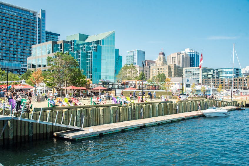
The Halifax Waterfront is located in Nova Scotia and represents a dynamic waterfront area that combines industrialization and nature. This study aims to survey and explore the Halifax waterfront area. This is important to collect data for analysis and study it to understand people’s impact on the natural environment of Halifax. This will reveal all the factors of the relationship between people, industrialization, and how they change the environment to organize space (Figure 1). Through the lens of spatial science, one can examine how coastal areas have changed while retaining their natural and historical significance.
The impacts of urban development and diverse natural ecosystems come together on the Halifax waterfront. The city’s history is long and goes back to the 18th century when it was an important trading hub connecting different functions. Thus, the development of infrastructure and development of the area has taken place since then, gradually transforming the embankment and changing its meaning.
People have adapted to the area to improve it and carry out the necessary operations so that the waterfront can become a center of commerce and entertainment. However, an essential aspect of this should have been the preservation of the authenticity of the area and its natural significance. Urbanization and active economic activity can significantly affect the landscape, making it more suitable for people (Shimaa et al., 2020). The theory of the relationship between people and the natural environment is full of important events that can change the order of things with large-scale urbanization (Shimaa et al., 2020). Spatial science focusing on preserving the site’s ecology and natural value is vital in considering Halifax as a significant monument of architecture and nature.
Methods
For this geographical study, the primary method was data collection since this is an essential aspect without which it would not be possible to start research work. The study of all data about the terrain of Halifax and its historical changes is vital for the scientific approach to considering urbanization and changes made by people. In addition, it allowed us to capture historical changes and the diverse orientation of the dam to make a detailed comparison of human interventions and their consequences.
The study of archival research and data is the first step that has become important in studying society’s influence on the area. Libraries, historical repositories, museums, and online databases formed a particular impression of the place of study (Werle,2022). To fully understand the significance of the area and how it has changed over time, such vital sources as maps, photographs, and other documents have been studied that helped to get an idea of the modernization of the dam in each period. Thus, a historical understanding of the development and change of the Halifax waterfront was drawn up.
In addition, field studies were an essential stage in data collection, which was carried out to study the dam’s current state in more depth. When visiting the area, Geographical information systems (GIS) technology was used to map structures built by man and created due to natural development (Werle, 2022). The land use and spatial relationship of various structures and commercial and residential areas help to study the extent of anthropogenic change.
Conducting interviews and surveys was necessary to understand the residents’ relationship with the place where they live better. Business owners and visitors to the various establishments and attractions along the Halifax coastline can discover different perspectives and views of the place they are in. The perceptions and experiences of the people who live and work on the waterfront can provide the necessary valuable knowledge that plays a role in uncovering the geographic determinants of the waterfront. Such qualitative data can provide insight into how different social groups respond to what is presented to them from a natural and industrial perspective.
A vital research method was socio-economic analysis, which was carried out to understand the income levels of the inhabitants of the area and their spending. In this way, it was possible to understand better what kind of life people lead and how financial resources are distributed in the area (Shimaa et al., 2020). People’s occupations, income level, education, and the relationship between social and spatial categories along the coastline were also subject to study to improve understanding of the economic importance of the waterfront. In this case, the historical perspective helped reveal the area as an essential trading hub that has evolved to become more of a tourist destination.
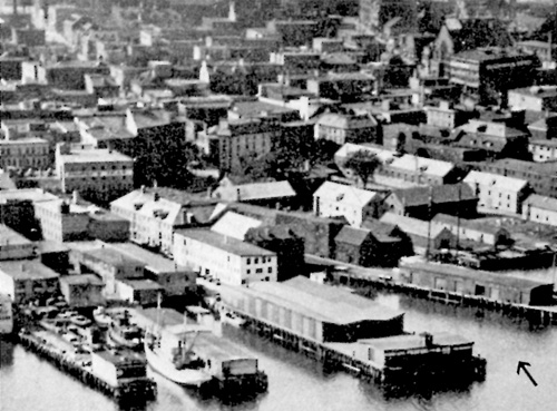
Spatial analysis was an essential element in assessing the changes in the landscape that occurred during the entire period of urbanization (Roe et al., 2019). This method allowed using an overlay of different data layers to measure how patterns and correlations changed through human actions taken in the study area. The physical and social landscape of the Halifax waterfront has been able to adapt to the needs of the people by constantly changing its functionality. For example, in Figure 1, in 1929, the dam was an important industrial and commercial center. During different periods of history, these changes led to results that constituted the ultimate importance of the region.
Theory
The theoretical developments that formed the basis of this work consisted of using the provisions of the concepts of the relationship between nature and society through urbanization. Nature-society relations theory highlights that people can significantly change their habitat by improving and modernizing the environment (Latorre & Malo-Larrea, 2019). It is noted that such changes are made with the involvement of different tools and means that help to make changes more efficiently. Thus, based on this theoretical basis, one can say that using side tools and developing a production society worsened the environmental background.
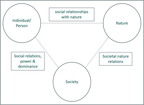
The theory helped to understand that people are separate organisms actively participating in the ecological ecosystem. Social actions in the form of urbanization could influence the fact that the coastal infrastructure has changed and become more developed than it was initially (Latorre & Malo-Larrea, 2019). However, the relationship between society and nature has allowed people to increase their understanding of how they can weaken and worsen the general state of nature in the region (Figure 3). Ecological systems and urbanization have been able to influence natural processes, and therefore, studying the two processes in an integrated manner is essential to understanding how this could improve or worsen the overall condition of the Halifax waterfront.
Spatial science theory has been able to focus research on how the analysis and visualization of landscape models relate to the artificial environment created by humans. This provides a prism for research through which one can more accurately examine and understand how urbanization has been organized and the changes made to the waterfront. The movement of people within the embankment and beyond its immediate boundaries has also become an important aspect that needs to be studied using a spatial science approach (Latorre & Malo-Larrea, 2019). This method is suitable for this work because it uses the collected data to comprehensively analyze the area.
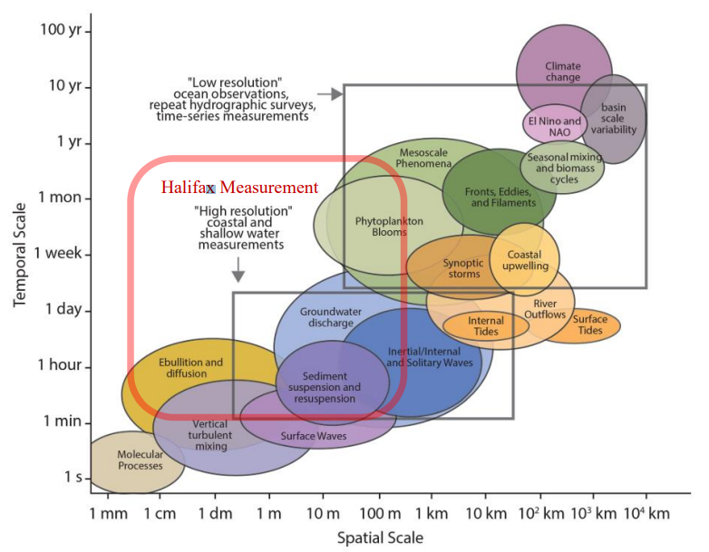
As seen from Figure 4, space distribution occurs in parallel with the area’s urbanization. Halifax’s urban infrastructure configuration can be analyzed to identify specific spatial disparities. This will help create recommendations for improving infrastructure and public space in the future.
For this work, a detailed literature study was carried out, which helped to create a general idea of what disciplines can help study the area. Studying the environment and sociology became the main elements that made it possible to trace the socio-economic patterns of people’s behavior in the region to structure them. The impact of the Halifax waterfront’s urbanization on the area’s ecological structure is the subject of research by some scholars (Campbell, 2023). Familiarization with their work gave me an idea of how this paper should move.
Theoretical studies of the historical reconstruction of the Halifax waterfront provided the basis for understanding what data to look for. This made finding information about the area and its history more accessible and efficient. Thus, the study revealed the main tasks set in the work. In addition, the urbanization of the coastal region has had a significant impact on the ecosystem, which requires a comprehensive assessment of the impact factors.
The connection of theory with research is because spatial science, society, and nature have a close interaction that can benefit all elements. The chosen theoretical framework can help to understand how human activity has affected the landscape and nature of the Halifax waterfront (Durgun Şahin & Dikmen, 2022). Relations between nature and man are not always based on mutually beneficial conditions. Therefore, paying attention to this aspect is part of the research work that requires the creation of a basis. Spatial science as a supporting theory can help study people’s influence by visualizing the changes made to provide a better and more detailed representation. This will reveal how humanity intervened in Halifax’s natural course of events.
Results
A hands-on geographic survey of the area provided information on how the landscape has been altered and what currently lies on the Halifax waterfront. It also helped establish relationships between the people who live and work in the area and the present determinants. Observations and study of various factors about the dam make it possible to conclude that the area is gradually being transformed from a place of trade into a more touristic and comfortable zone.
In addition, a significant expansion of urban infrastructure has been observed, which correlates with observations about urbanization. The distribution of commercial and recreational areas and accommodation are new buildings that have completely rebuilt the historical landscape of the area. An analysis of the demographic component showed a social stratification that influenced what kind of people usually visit the area.
Testing and sampling of natural sources such as water indicate significant pollution that began to appear with the growth of urbanization. Thus, people who carry out the urbanization processes of the location do not pay enough attention to ecology and care for the environment. This has led to the pollution of natural water and other natural resources. This is also facilitated by the expanding tourist traffic, which attracts many people who do not care about a place where they will not stay for a long time.
Dense tourist traffic is formed due to the places of attraction that will form along the entire perimeter of the Halifax waterfront. In the aggregate, in this location, there is an imbalance between social needs and the surrounding state (Durgun Şahin & Dikmen, 2022). This is manifested in the fact that people have done a lot of work to change the terrain without paying attention to the consequences.
Analysis and Discussion
The analysis of the results obtained after a detailed study of the area around the Halifax waterfront suggests the need to connect these data with the theoretical foundations for scientific understanding. The relationship between nature and society has evolved, making the waterfront a destination for tourists who want to enjoy the natural scenery. Thus, linking observations to a theoretical basis, it is worth saying that society transformed the available area in such a way that it corresponded to new goals that manifest themselves in satisfying needs (Rahman et al., 2019). Tourist terrain prevails on the waterfront, which indicates the relationship between people and natural landscapes.
Based on the observations obtained, it can be said that the relationship between nature and society in the context of the historical evolution of the Halifax embankment leans towards urbanization. The trading post began to become an urban center by building many buildings for various purposes (Durgun Şahin & Dikmen, 2022). Thus, human activity in this region is cumulative, which has contributed to enhancing the development of the waterfront. Historical analysis through the overlay of historical maps indicates that nature has been quite strongly preserved on this piece of land. Thus, the theoretical prerequisites for the mutual separation of nature and human intervention are manifested on the embankment.
In the context of spatial science, Halifax’s coastal infrastructure and socio-economic focus resonate with the dynamics of natural development. The distribution of spatial organization is arranged in such a way as to distribute the infrastructure in a commercial way (Durgun Şahin & Dikmen, 2022). The analysis carried out demonstrates the vision of urban urbanization as a distributive image of economic factors and reveals the relationship between places of attraction for the entertainment complex and commerce. Thus, an economic connection of infrastructure is formed that ensures the development of the human sector.
The environmental impact of urbanization on the waterfront reflects the relationship between how people inhabit and urbanize the area and how the waterfront maintains its historical significance and natural components. However, there are differences in water quality parameters that have been measured and whose parameters have changed significantly due to human activities (Durgun Şahin & Dikmen, 2022). The theory of the relationship between nature and society supports the idea that harmony and balance must be observed in order to be able to fully carry out urbanization without harming the environment. However, the spread of tourism activities in this region has contributed to the fact that a large flow of people has complicated the care of nature in the area.
The spatial organization of an area of high social organization emphasizes the importance of proper site planning. Social communication nodes can be improved over time in order to establish a more comprehensive and holistic program that will improve the condition of the waterfront (Üzümcüoğlu & Polay, 2022). At the hubs of communication, the interaction of people with nature must be tangible in order for them to become more aware of the importance of preserving the historical value of the Halifax waterfront. The development of the urban landscape is of critical value, however, the public must be aware of the need to ensure the care of the environment.
Conclusion
A geographic overview of the Halifax waterfront area has been completed with practical research as well as overlaying the area’s historical perspective on its present-day appearance. This gave an idea of how the embankment has changed over time and what shortcomings were made during the development of this territory. In addition, the theory of relations between nature and society was applied, which made it possible to fully consider how people changed the territory.
The role of public spaces is quite significant and plays a role in the distribution of socio-economic tasks and indicators. In the future, work can be done to study the consequences of development on the cultural identity of residents. This paper contains some limitations, the main of which are time frames and superficial socio-economic ties.
References
Buggey, S. (n. d.). Halifax Waterfront buildings: An historical report. Parks Canada History. Web.
Campbell, C. (2023). Hardened water: The remaking of a coastal city. Coastal Studies & Society, 2(1), 112-136. Web.
Durgun Şahin, Y. & Dikmen, Ç. B. (2022). A Holistic Reading of The Streetscape and Building Articulation: The Case of The Canadian City of Halifax. Gazi University Journal of Science Part B: Art Humanities Design and Planning, 10(3), 303-322. Web.
Eversberg, D., Koch, P., Holz, J., Pungas, L., & Stein, A. (2022). Social relationships with nature: elements of a framework for socio-ecological structure analysis. Innovation: The European Journal of Social Science Research, 35(3), 389-419. Web.
Hellmich, M. (2022). Ocean-air N2O trace gas fluxes in Halifax Harbour derived from open-path FTIR measurements[Master Thesis] Saint Mary’s University. Web.
Latorre, S., & Malo-Larrea, A. (2019). Policy-making related actors’ understandings about nature-society relationship: beyond modern ontologies? The case of Cuenca, Ecuador. Ecological economics, 156, 387-396. Web.
Rahman, H. T., Sherren, K., & Van Proosdij, D. (2019). Institutional innovation for nature-based coastal adaptation: lessons from salt marsh restoration in Nova Scotia, Canada. Sustainability, 11(23), 6735. Web.
Rajbhandari, R. (2021). An examination of the household characteristics of high-density neighbourhoods in Halifax, Canada [Master Thesis] Saint Mary’s University. Web.
Roe, J., Barnes, L., Napoli, N. J., & Thibodeaux, J. (2019). The restorative health benefits of a tactical urban intervention: an urban waterfront study. Frontiers in built environment, 5, 71. Web.
Shimaa M. Ali, Amr N. Mohamed, Nourhan El Sohafi. (2020) Towards A Sustainable Waterfront Development “Case Study of Port Said City”. International Journal of Environmental Science, 5, 104-115. Web.
Üzümcüoğlu, D., & Polay, M. (2022). Urban Waterfront Development, through the Lens of the Kyrenia Waterfront Case Study. Sustainability, 14(15). Web.
Werle, D. (2022). Early Canadian Aerial Photography: The St Croix River and the International Boundary, 1921. Scientia Canadensis, 44(1), 68-82. Web.
Young, B. (2023). Halifax Waterfront: The summer hotspot. Saltwire. Web.