Selected Area Description
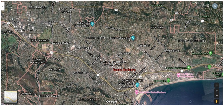
The selected area for the Biome Project is the small city Santa Barbara, California, on the Western coast. The town is located near the coastal line and has borders with natural resorts and reservations. Moreover, the city has no evident or visible sights of agricultural land or manufacturing areas.
Nonetheless, it can be admitted that Santa Barbara, CA, represents the urban area, which indicates that the land is mostly used for constructions, commercial buildings, residential areas, and resort areas near the coastal line. In this case, the property is used for residential purposes, which questions whether the land resources are adequately appropriated.
As a result, further investigations during the project should be focused on analysis, whether the land near Santa Barbara, CA, can be used for any other purposes other than residential or commercial areas. Furthermore, the study on land use may indicate how the urban areas may effectively utilize natural resources for their better appropriation and reservation. In return, the determined solutions and proposals may assist in better planning of urban and suburban areas to decrease the pressure on the land resources and increase the comfort and convenience of residents in the selected region.
Historic Perspectives
The historical perspective on land use in the U.S. and the selected region in California provides controversial views on how the land was utilized in different areas. It can be stated that during the 17th and 18th centuries, the land in the U.S. was seen as the property for the agricultural and primary source of entrepreneurship (Miller et al.). People purchased land not only to feed their families but also to establish trade and economic relations with nearby towns, cities, regions.
Further, the industrial revolution shifted the use of land from agriculture to manufacturing, as more plants have been established to sustain economic growth. At the same time, the residential property became more popular due to the decreased need for agriculture, farming, and cattle breeding (Jackson 50). What is more, the analysis of the Santa Barbara region indicates that the use of land for entertainment and residency became a new trend during the 19th century.
The further development of the U.S. economy suggests that the land became a utility to fulfill the consumerism and people’s need to have private property. The appropriation of this natural resource obtained new perspectives. People tend to purchase land for their needs, like a residential area, entertainment, additional or luxury property.
Current Land Use
The current situation with the land appropriation indicates that the Santa Barbara area is primarily used for residential and commercial buildings. The aerial images suggest that the urban area covers a prominent part of the selected region, leaving small zones for forests and green zones, like parts, zoos, and recreational sights. In this case, it is believed that the city will further grow and expand the current area by covering either nearby hills or coastal lines (MacLachlan et al. 38). As a result, the transformation of the domain is inevitable so that the future projections may not include sustainable practices to protect and renew the green zones, forests, and natural reservations.
Future Projections
The future projections about land use in the country and Santa Barbara, CA, suggests that this natural resource will be used for economic and social needs rather than for natural reservations or agriculture. The increased number of enterprises, plants, and SMEs requires more land to utilize for their business conduct. Besides, the selected area and its closeness to coastal lines make Santa Barbara’s property beneficial for entertainment and residential areas (Wilson, Sleeter and Cameron). It can be predicted that shortly, the available land will be occupied by commercial or residential buildings to satisfy the economic or social needs of the local population. Moreover, nearby forests and green zones might be under threat due to the ongoing expansion of the urban area. As a result, the current aerial images of the city might significantly change.
On the contrary, California is known for its environmental policies and sensitivity to sustainable and eco-friendly businesses. Such a position may assist in the reservation of land for more valuable activities, like natural resorts, agriculture, or wildlife habitat (Cameron et al. 12835). If such changes take place, the area near Santa Barbara and within the town may become greener and better protected from over-construction. In return, such actions will increase the attractiveness of the area and its recreational capabilities due to the combination of forests and coastal zone.
Conclusion
The conducted primary analysis of Santa Barbara, CA, aerial images, and urban areas provides information that the expansion of the town will only continue. The review of historical trends and changes only confirms that land use is shifted from agriculture and cattle breeding to entertainment, residential, and commercial appropriation. As a result, the future revisions of the landscape offer controversial perspectives. California makes attempts to sustain land use and integrate eco-friendly practices. On the contrary, small towns like Santa Barbara show expansion and growth throughout the years.
Works Cited
Cameron, D. Richard, et al. “Ecosystem management and land conservation can substantially contribute to California’s climate mitigation goals.” Proceedings of the National Academy of Sciences, vol. 114, no. 48, 2017, pp. 12833-12838.
Jackson, Kristoffer. “Do land use regulations stifle residential development? Evidence from California cities.” Journal of Urban Economics, vol. 91, 2016, pp. 45-56.
MacLachlan, Andrew, et al. “Urbanisation-induced land cover temperature dynamics for sustainable future urban heat island mitigation.” Urban Science, vol. 1, no. 4, 2017, p. 38.
Miller, David L., et al. “Urban Gross Primary Productivity across Diverse Vegetation and Land-Use Types.” AGU Fall Meeting Abstracts. 2018.
Wilson, Tamara S., Benjamin M. Sleeter, and D. Richard Cameron. “Future land-use related water demand in California.” Environmental Research Letters, vol. 11, no.5, 2016.