Introduction
Thorough research and understanding of the problem of spatial distribution, and the phenomena of the principles of spatial distribution is a great challenge nowadays. The issues of spatial distribution entail the knowledge from different areas, such as healthcare, environment, geology agronomy, and lots of others. These studies become more and more available due to the expansion of Geographic Information System (GIS) with user-friendly interfaces, and, also, due to the spread of global knowledge via the internet and mass communication systems.
These systems offer a great opportunity to research spatial distribution by the means of visualization of different variables. The Spatial distribution itself offers the great opportunity to study the opportunities and constraints of the living or working space, define the key ways of communications, create a plan of a city or a single building, define strategic points of any territory.
Case studies. Opportunities and constraints
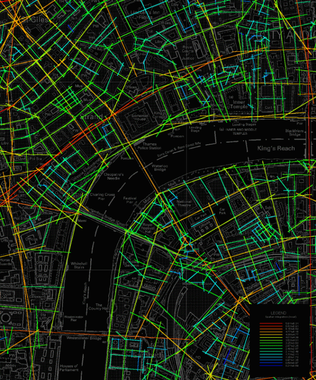
The case studies of Space Syntax represent the spatial analysis that was held to define all the opportunities and constraints within the municipal territory. Originally, this analysis (map 1) is held to study the communication ways of social systems and infrastructure location. The analysis of these communications, locations and spatial accessibility is always used for planning the transportation networks and routes, building designs and planning of the recreation zones. As experts emphasize (Howard, 2005), this data is essential for land and city management, especially if it is subjected to floods, hurricanes or volcano eruptions. It is necessary to take into account all the data available, as it would help to avoid essential losses during these cataclysms. On the other hand,
Spatial analysis, if applicable to social sphere helps to gather the necessary data for city planning and development. In this case Space Syntax project would help to increase the living space of citizens and avoid traffic jams and crowding during rush hours.
However, it is impossible to plan any other activities without further analysis, which should be technical. This type is always arranged as the second phase of the ecosystem study (if necessary). This study is aimed to analyze the relationships of connectivity, open space, amenities and views, and also physical characteristics such as slope, aspect, soils, and vegetation. Technical study is aimed to define the attractiveness of the recreational zone, locate all the points of infrastructure linkages, plan possible improvements of the recreational process.
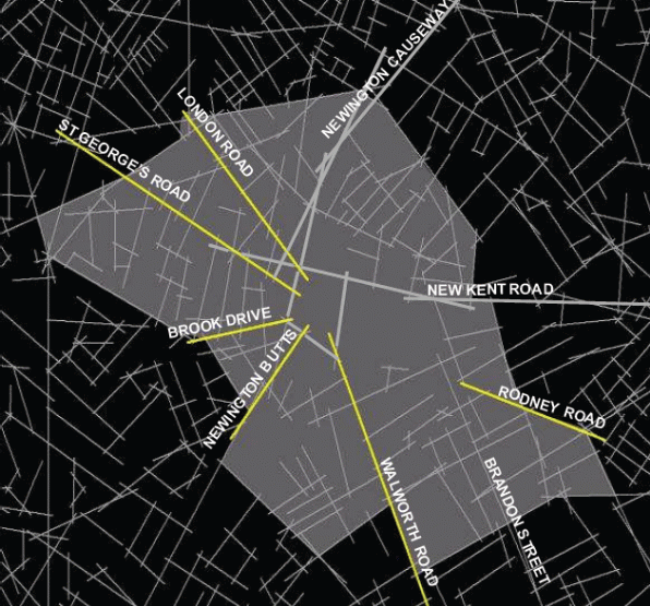
Along with the special analysis, Space Syntax offers the creation of new connections of communications. It is necessary to emphasize, that if there are natural obstacles (rives, mountains etc), the building of new bridges and tunnels provides more social space (by unloading other connections). It is shown on Map 2 that the new roads (pictured yellow) were aimed to decrease the trafficking overload. Space Syntax project offers the redefining a districts by providing additional space.
Daily traffic visualization and analysis may be used to solve the wide range problems: avoiding traffic jams, finding a way to any point, avoiding road patrol posts, select a way for a new road (railway, subway) in order to unload the most loaded ways.
The qualitative analysis of the different locations provides the date, which is helpful for various aims, and these aims have been already described. The fact is that Spatial analysis is a part of ecological study, and originally was aimed to prevent locations from pollution, contamination, littering etc. However, further it became the complex and allover study for solving close to ecological problems.
The key significance of Spatial Analysis is to define and measure locations and ecosystems, taking into account the spatial position of the problematic places that may become a reason of a cataclysm or catastrophe. The spatial analysis is the central notion for the incorporation of the space, and the study of special features of any geographical location.
Problems of Spatial Analysis
As it has been stated above, the Spatial Analysis deals with the environmental and socioeconomic data. Anyway, this analysis is based on the set of chained procedures, aimed at selecting a deductive model that clearly analyzes the spatial relations of the location or phenomenon (if social processes are studied). Generally speaking, the modeling process is prefaced by a phase of exploratory research, which is aimed at creating the visual model of the analyzed data. Thus, the spatial analysis is impossible without visualization, and requires reliable data to be presented. However, the special analysis is not a universal tool, and there are some difficulties and constrained linked with it.
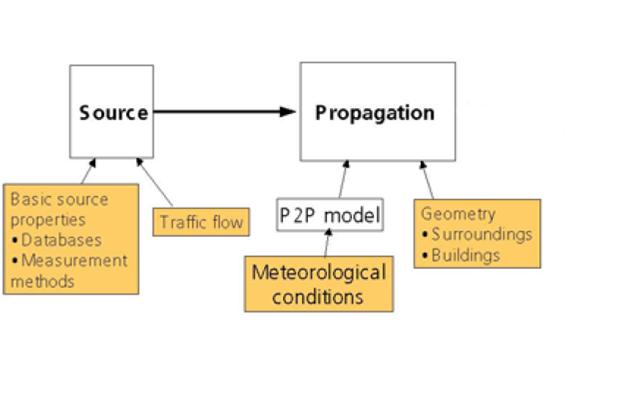
Thus, the noise study in London is impossible without some additional studies (social, metrological and ecological). The chart 1 shows the structure of noise study, which was held in London in order to define the largest sources of noise that stressed and plunged people into depression. The research process included visualization (Spatial Analysis), however, it appeared insufficient, as ecological and social researches were not held. Visualization itself cannot offer reliable data on the problem. It is a tool aimed to systematize any data associated with definite geographical location. (Baumont, 2004)
Thus, in order to study the issue of city noise it is necessary to take into account the following factors: terrain model, characteristics of the ground, buildings, traffic infrastructure (including roads, railways and subways), noise protection devices, traffic (road, railway and air), industrial sources, meteorological and population data. Some of these factors (terrain model, characteristics of the ground) can not be visualized, as they require detailed explanation. Nevertheless, the selected criteria are essential for the noise study. It signifies that all the necessary factors, necessary for the analysis of the socio-ecological problem require also geographical application. (Goodchild, 2004)
Conclusion
Spatial analysis is regarded to be the visualization tool for solving the wide range of issues, closely linked with social and ecological factors in inhabited areas, or areas, intended for further settlement. In spite of the fact that it is quite universal, there are some restrictions that require the application of additional studies in order to represent the allover image of the issue.
The Opportunities and constraints that are offered by Space Syntax project are regarded to be the essential analysis of living space expansion, territorial and city management. Visualization of spatial data is the powerful tool which may be used for numerous aims.
Appendices
Works cited
Baumont, Catherine, Cem Ertur, and Julie Le Gallo. “Spatial Analysis of Employment and Population Density: The Case of the Agglomeration of Dijon 1999.” Geographical Analysis 36.2 (2004): 146.
Goodchild, Michael F., and Donald G. Janelle, eds. Spatially Integrated Social Science. New York: Oxford University Press, 2004.
Howard, Allen M., and Richard M. Shain, eds. The Spatial Factor in African History: The Relationship of the Social, Material, and Perceptual. Boston: Brill, 2005.
Klinkenberg, Brian. “Spatial Analysis of the Coincidence of Rare Vascular Plants and Landforms in the Carolinian Zone of Canada: Implications for Protection.” The Canadian Geographer 46.3 (2002): 194.
Mccord, Eric S., and Jerry H. Ratcliffe. “A Micro-Spatial Analysis of the Demographic and Criminogenic Environment of Drug Markets in Philadelphia.” Australian and New Zealand Journal of Criminology 40.1 (2007): 43.
Pacione, Michael. Applied Geography: Principles and Practice: An Introduction to Useful Research in Physical, Environmental and Human Geography. London: Routledge, 1999.
Rey, Sergio J., and Luc Anselin. “Recent Advances in Software for Spatial Analysis in the Social Sciences.” Geographical Analysis 38.1 (2006): 1.
Robertson, Elizabeth C., Jeffrey D. Seibert, Deepika C. Fernandez, and Marc U. Zender, eds. Space and Spatial Analysis in Archaeology. Calgary, Alta.: University of Calgary Press, 2006.