Introduction
This paper provides an in-depth overview of the Upper 11-Abercrombie site in New South Wales, Australia. Its primary goal is to provide colleagues with essential knowledge before conducting field surveys to determine instream and riparian health. This introduction provides an overview of the site’s geographic coordinates, with a focus on its location within the broader Upper Lachlan watershed. This study aims to lay the groundwork for informed decision-making and effective data collection during future fieldwork by exploring critical topics, including geology, hydrology, topography, vegetation, land use, climate, and river features.
Catchment Description
Location
Site Name: Upper 11 – Abercrombie, NSW
Longitude: 149.312031
Latitude: -33.955183
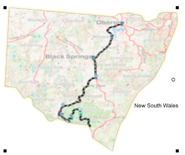
Catchment Context
Geology
The geology of the Upper 11 – Abercrombie catchment is characterized by sedimentary rock formations, with sandstone and shale being particularly common, as shown in Figure 1. These geological features have significant consequences for the overall environmental dynamics of the basin. The porous structure of sandstone impacts water penetration and retention in the soil. Shale, on the other hand, is often less porous, altering groundwater flow patterns. The interaction of various rock types directly impacts soil composition, resulting in differences in soil texture and nutrient content across the catchment.
The underlying geology influences plant distribution, root penetration, and nutrient availability through variations in soil composition. Groundwater flow patterns are influenced by the permeability of sandstone and the comparatively impervious makeup of shale. Sandstone facilitates quicker groundwater circulation, which may result in enhanced baseflow in the river during dry seasons. In addition to their impact on groundwater, geological characteristics are crucial to the watershed’s hydrology. Surface runoff, streamflow, and groundwater recharge are all influenced by the different permeabilities of rock strata, which alter how precipitation infiltrates the earth.
Topography
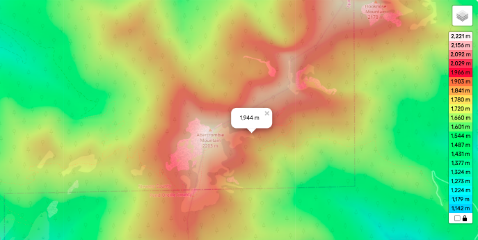
The catchment’s topography exhibits considerable variety, transitioning from rugged highlands in the upper parts to softer slopes as it descends to lower altitudes. These topographical changes have a significant impact on the morphology, hydrodynamics, and ecological dynamics of the river. The catchment’s higher portions, characterized by rugged highlands, often feature steep slopes and rocky terrain. The landscape progressively flattens as the catchment moves towards lower altitudes.
Meandering streams, marshes, and floodplain regions can all be found in transition zones, as illustrated in Figure 2 (Williams & Roberts, 2005). The lower regions of the catchment are characterized by gentler slopes, which can lead to broader, slower-moving river sections. These areas may exhibit braided patterns, riffles, and pools, providing diverse habitats for aquatic organisms.
Land Use
Land use within the catchment is diverse, encompassing various human activities that can directly and indirectly impact the river’s health and water quality. Agricultural pursuits, including crop production and cattle grazing, are typical within the catchment. In particular, livestock grazing can potentially worsen water quality and aquatic ecosystems by increasing sedimentation and nutrient runoff into rivers. Forestry operations can impact water quality due to soil disturbance and possible erosion during logging operations. The catchment’s conservation zones are crucial havens for wildlife.
Landscape Units: Mapping
Upland forests, riparian zones, agricultural fields, and conservation areas are just a few of the places with distinct features that comprise the Upper 11 – Abercrombie catchment’s landscape units. These organisms are crucial elements of the catchment’s ecology, and each has a unique impact on the condition and dynamics of the river. These landscape components have a direct impact on the river’s health. For instance, upland forests improve water quality by removing contaminants and preserving the soil.
Climate Context: Meteogram
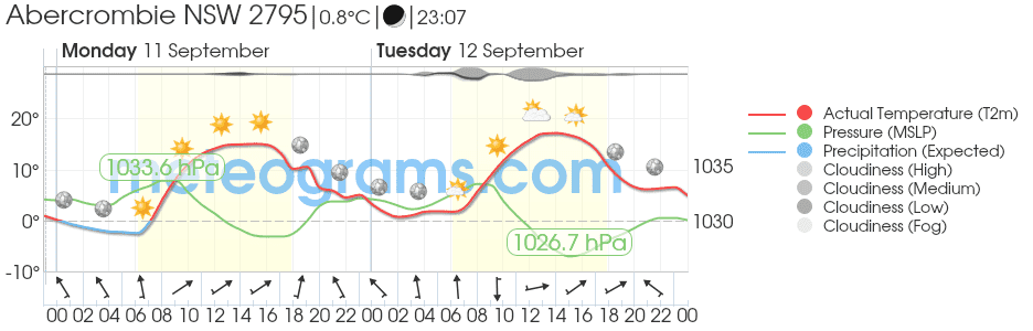
The data from the nearest rainfall station (Abercrombie) was used to create a meteogram. The meteogram offers valuable insights into seasonal climate variations by displaying temperature fluctuations, precipitation patterns, wind speeds, and other meteorological factors, as illustrated in Figure 3.
Hydrology: Flow Records
According to the data in Figure 3, the area’s hydrology implies relatively constant and dry circumstances. The closest weather stations have not seen any appreciable rainfall since 9 a.m. Due to the lack of recent precipitation, the river’s flow may be impacted, resulting in decreased water levels (Australian Government Bureau of Meteorology, 2023b). The pace of snowmelt or runoff from higher altitudes may also be influenced by temperature changes, ranging from below-freezing to comparatively cold temperatures, which could further alter river flow patterns (Australian Government Bureau of Meteorology, 2023b).
Vegetation and Land-Use Impact: Vegetation Mapping
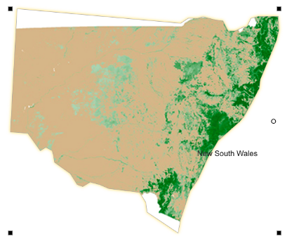
The catchment’s comprehensive vegetation map has been created, highlighting various plant types and land-use regions. This mapping aids in identifying potential implications of land use, such as erosion and changes in nutrient levels, which can have immediate impacts on river health (Roff et al., 2022). Figure 4 provides a spatial representation of land use and vegetation within the watershed, allowing us to anticipate how these elements may impact the river’s physical properties, water quality, and ecological integrity.
River Characteristics
Channel Description
The river’s planform is characterized by meandering, with sinuous bends throughout the watershed. The channel slope often ranges from steeper gradients in the upper sections to gentler slopes downstream, depending on the catchment’s topography, as shown in Figure 5. The stream’s geometry, which includes riffles, pools, and bars, produces a range of aquatic habitats.
The mainstream of the basin is notable for its geomorphic variation and meandering river type. The underlying geology and the river’s shape are closely related. For instance, if sandstone dominates the catchment’s subsurface, the river may have a meandering flow due to the rock’s susceptibility to erosion.
On the other hand, if shale is typical, the river may follow a straighter, more entrenched channel (Barry, 2021). Instream characteristics, such as riffles, pools, and bars, can be predicted using geological and river form analysis. Sandstone is likely to contribute to a more dynamic, sinuous channel, while shale is likely to contribute to a relatively stable, straighter channel.
Geology and River Style
The catchment’s dominant sedimentary rock formations, which lie underneath, significantly impact the river’s character. Rock outcrops and narrow rivers are typical in the higher portions, whereas larger, more sinuous channels may be present below. Predicting instream characteristics is much easier with an understanding of this geological effect.
Survey Site Recommendations
This report proposes the following 3 sample survey areas for more thorough field surveys based on the thorough study of the watershed:
- Upper Reaches – Rocky Outcrops and High Gradient:
- This location features the steeper upper stretches of the river, characterized by stony substrates, highlighting the high-gradient features of the basin.
- Mid-Reaches – Meandering Channel with Riparian Vegetation:
- This area illustrates how the river meanders and interacts with the surrounding riparian vegetation, offering insight into the ecosystem’s dynamics.
- Lower Reaches – Braided Patterns and Agricultural Interface:
- To address the implications of land use, surveying this area will assist in understanding the river’s braided patterns and its contact with agricultural fields.
Conclusion
The Upper 11 – Abercrombie location within the Upper Lachlan catchment is thoroughly explained in this study, which also covers the geology, topography, land use, climate, hydrology, vegetation, river features, and suggested survey sites. Colleagues conducting field research to evaluate the instream and riparian health of this area will find the information presented to be of the utmost value.
Reference List
Australian Government Bureau of Meteorology (2023a) Abercrombie River Weather and warnings information, Abercrombie River Forecast – Bureau of Meteorology.
Australian Government Bureau of Meteorology (2023b) Abercrombie weather and warnings information, Abercrombie Weather – Bureau of Meteorology.
Barry, L. (2021) Abercrombie River NP, ExplorOz.
Roff, A. et al. (2022) Department of Planning and Environment NSW State Vegetation Type Map, State of NSW and Department of Planning and Environment.
Williams, D.G. and Roberts, J. (2005) Riparian vegetation diversity in the Sydney Catchment Authority’s area of operation, Cooperative Research Centre for Freshwater Ecology.