Abstract
The city of Alexandria is located in northern Egypt. The city has been one of the major ports in the Mediterranean and many tourists travel to the beautiful city. Geographically the city is located on the coast of Egypt and a major portion of the city is composed of beaches, which is the major attraction in the city for tourists. The city has been well known around the world for having the largest seaports and being the second-largest city in the country. This paper shall be dealing with the natural hazards that are being faced by the habitants in the city of Alexandria along with the many factors that can cause these natural hazards. Mainly it has been seen that there has been a significant seismic activity in the city thereby the factors causing these seismic activities shall be discussed in the paper.
Introduction
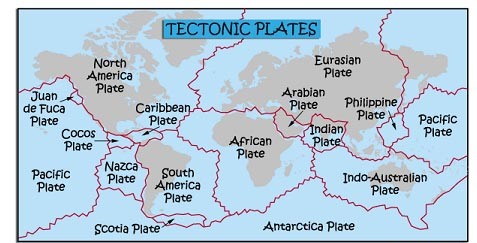
Egypt is the country that has been studied by the geographical analysis and the environmentalists in a deeper manner. This is the analysis that has shown that Egypt is a country which is located in the northern part of the African continent. This is the analysis that has been made in relation to the studies on volcanoes and the earthquakes noticed by the seismologists in the region. These crustal dynamics studies show that the African continent is a stable region except the east African rift, which is located near Kenya, and Ethiopia (El-Sayed, Korra, Hussein, 56). This unstable part has been causing many earthquakes in the region for many years. The branches of the East African rift meet the Red Sea, Gulf of Aqaba, Gulf of Aden, and Gulf of Suez. A higher ratio of the crustal movement has been noticed in the Gulf of Aqaba.
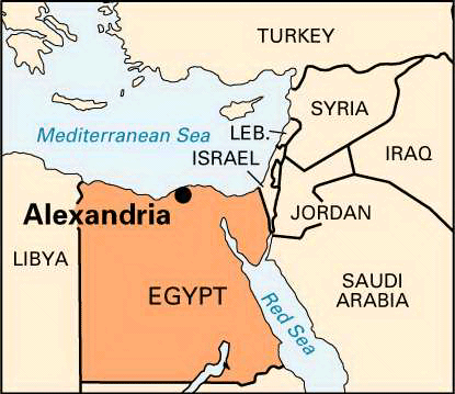
The geographical map of the city of Egypt shows that the city of Alexandria is located near the Red Sea. The Red Sea rift is located on the eastern side of Egypt. Red Sea rift has been known as the zone of plate separation (El-Sayed, Romanellia, and Panzaa, 34). This has been seen to accompany the seafloor spreading causing the separation of African plates and Arabian plates. This area has been associated with low level, rather shallower seismic activity. However, it has been added by the analysts that the major seismic activity has been related to the central axial trough of the rift. In addition to this, it has been seen that there is a tectonic plate junction at the intersection between the Red Sea rift, the Gulf of Aqaba, and the Gulf of Suez.
It is noticed that the northern part of the Red Sea rift in the zone, which is of high importance in relation to the seismic hazard that has been seen in Egypt especially in the city of Alexandria for some years. It has been seen that Egypt is a country that has moderate seismic activity however the existence of the major tectonic plate structures are the ones that predispose some of the cities of the country to major or minor earthquakes (Brewer, and Teeter, 34).
There has been a significant increase in the population of Egypt as there is massive urbanization. Thereby it has been seen that the population of the cities of Egypt has also substantially increased in the past years. This increase has been the greatest in the case of the cities as Cairo Gaza and Alexandria whereas the estimated population of Alexandria is 4 million. Thereby these are the natural hazards that have been the cause of concern in relation to the increasing population of these cities in Egypt. Alexandria has been considered as one of the cities that have been very well developed and because of this reason; these are the regions that are to be given social attention owing to these forms of natural hazards.
It has been added that there are five main geographic areas and cities in Egypt that have been considered sensitive to earthquake hazards. These five areas include the area that surrounds the Red Sea and the junction that covers the Gulf of Suez and the Gulf of Aqaba and this region includes the city of Alexandria (McKenzie 45).
In the case of the Red Sea, it has been studied that the northern limit of the Red Sea lies on the triple tectonic plate junction and this has been seen to be associated with the rifts of the Red Sea including the Gulf of Suez and the Gulf of Aqaba. This is the main zone that has been linked with the considerable amount of seismic activity that has been noticed in the past few years and one of the examples has been the Shadwan earthquake. An increased amount of seismic activity is noticed in the regions near the Red Sea where there are higher numbers of the unconsolidated coastal and fluvial segments.
In addition to this, it has been seen that Egypt is exposed to secondary natured natural hazards and these are the natural hazards whose frequency has been increasing the intensity of the seismic activities in the areas surrounding the Red Sea including the city of Alexandria. These are the secondary natural hazards that have been referred to as the earthquake related phenomena and these include the liquefaction, the tsunamis, landslides and rockfalls and the earthquakes themselves.
Seismic sea waves or the tsunami has been related to the earthquakes in Alexandria in the recent times. Liquefaction is the phenomena in which the soils change from there solid states to the liquid states due to the extensive drainage. In this case it has been seen that the earthquake liquefaction causes an increase in the pore water pressure thus decreasing the effective stress of the sand having a capacity to withstand the seismic waves thereby the liquefaction phenomena has been linked to one of the earth quakes that hit the Alexandria recently (Pelling 45).
There has been a substantial proof that the Red Sea rift has been associated with the substantial volcanic activity. The main areas that have been considered as seismically active are the northern and southern parts of the Red Sea rifts.
In the case of development of the cities in Egypt especially in the city of Alexandria, it has been seen that there is an increase in the construction and the buildings. These buildings are sensitive to the motions that are caused by the earthquake thereby causing an increase in the risks of earthquakes. This is the problem that has been acutely noticed in the cities if northern Egypt as Alexandria as Alexandria is the main city that is effected by the distant earthquakes that occur in the eastern Mediterranean regions. These are the aspect that are to be taken into consideration when the analysis is being carried out on the accumulative hazards of the earth quakes on Alexandria and in the other cities of the northern Egypt.
Alexandria has been known for the underground structures and the monuments that it has as these are the attraction for many tourists. These monuments and structures that have been considered as sensitive to the seismic waves. The main factors that have been associated with this sensitivity include aging of the construction, rising underground water level and the weathering. These factors have affected the sensitivity of the buildings in Alexandria. Therefore it has been said that the ancient monuments and archeological sites that are located in the Mediterranean basin are the ones that are to be protected. There are some subterranean monuments in Alexandria have been excavated and these have an intrinsic sensitivity to the seismic waves and the weathering factors as the rising water level salt weathering effects. One of the main factors that has been increasing the sensitivity of the underground monuments and the buildings to the seismic effects has been the seeping in of the underground water through the porous rocks. The weathering phenomena have been related to the poor geotechnical properties including the chemical carbonated composition and the presence of any soluble salts in the porous systems. These also include the marine systems that have a certain level of humidity associated with it. It has been added that the silica content has been seen to play the role in the strength of the rocks in these monuments thereby defining the strength as being high or low (Brewer and Teeter 45).
Many available mechanisms have addressed the presence of certain stress regimes between the Hellenic Arc that links to the Alexandria offshore area. There are many numerical studies that have been carried out on Alexandria and it has been seen that there is a quantitative seismic hazard associated with Alexandria. The response spectra have been calculated for the city of Alexandria and it ranges around having a magnitude of 6.7 having an acceleration of 300cm/sec2 and the total duration being three seconds (McKenzie 38).
Conclusion
Alexandria is an Egyptian city, which is well populated being a trade port holder and a successful tourist attraction city. However being sensitive to the seismic activity, there may be a negative impact on the overall image of the city thereby there are some considerations that are needed in order to change the current sensitivity to the seismic activity.
Bibliography
Brewer, J. Douglas., and Teeter, Emily. Egypt and the Egyptians. Edition 2. Cambridge University Press, 2007.
El-Sayed A., KorraT I., and Hussein H. M. “Seismicity and seismic hazard in Alexandria (Egypt) and its surroundings”. Pure and Applied Geophysics 161 (2004): 1003-1019.
El-Sayed, A., Romanellia, F., and Panzaa, G. “Recent seismicity and realistic waveforms modeling to reduce the ambiguities about the 1303 seismic activity in Egypt”. Tectonophysics 328 (2000): 341-357.
McKenzie, Judith. The architecture of Alexandria and Egypt, c. 300 B.C. to A.D. 700; The Pelican history of art: Yale University Press Pelican history of art. Yale University Press, 2007.
Pelling, Mark. Natural disasters and development in a globalizing world. Routledge, 2003.