Remote sensing is defined as the measurement of information and area property on the Earth’ surface by means of satellites and aircrafts. This process helps to evaluate and obtain data at a distance in case the object under consideration is not located in direct contact (Schowengerdt 2). In this regard, remote sensing consists of optical, microwave, and acoustic signals allowing to analyze any climate changes and to provide solutions to the current ecological situation.
Remote sensing technology dates back to the nineteenth century, beginning with the overhead photography of landscapes acquired from various devices. Gaspard Tournachoon, an outstanding portrait photographer who is also known as Nadar, made his first overhead photographs in 1861 from the balloon (Olsen 1). The rapid expansion of this field began in 30s and 40s of the past centuries and was marked with invention of airborne photography (National Research Council 13).
But the obtained photographic images were too small and could hardly operate on a national scale. Later on, in a postwar period, the previous developments were advanced into the invention of thermal-infrared and radar systems. There were also cameras that were applied to remote sensing before the development of artificial satellites (Khan, Sherieff, and Balakishan 2). In 1972, the first remote sensing satellite was launched and that marked the rise of global-scale remote sensing.
However, the remote sensing applications were not accepted due to insufficient resolution of the satellite imagery as compared with airborne imagery. Such kinds of satellites are still used, but in a more advanced techniques. In 1978, the public saw the invention of radar remote sensing satellite whose information was provided for three months only (Gibson and Power 10). Radar satellites were introduced in 1995 by a European associate and by Canada (Gibson and Power 11).
Nowadays remote sensing systems, specifically those installed on satellites, provide a consistent view of the earth and can influence human activities. In this regard, there a number of significant applications of remote sensing technologies that are listed below:
- global and climate change detection and control, including deforestation, ozone depletion, greenhouse effect, and global warming;
- meteorology (weather prediction and atmosphere dynamics);
- mapping, which includes land use, civil engineering, and topography;
- evaluating and evaluating the environment, including hazardous waste and urban growth;
- military surveillance for tactical assessment and strategic policy;
- searching for renewable natural resources (soils, wetlands, forests, and oceans).
With regard to the above, remote sensing applications, a wide range of spectral, spatial, and temporal parameters, have been evolved (Chuvieco 15). In particular, there should be specific remote sensing devices enabling to observe temporal transitions, such as the forests areas, the sea surface temperature, and the state of sea ice.
Considering climate change policy, the realization of short-term goals is a significant first step. However, in order to work out effective climate strategies, it is necessary to focus on long-term programs aimed at achieving a consistent transition to an emission-free economy. The course taken on long-term policies requires a wide spectrum of policy that clarifies the connection between various land-uses and greenhouse gas emissions with the help of remote sensing applications (Hasselman et al. 1923). The application of such innovative technologies is the best way to face the challenges of the current situation.
Due to the fact that there are different types of remote sensing technologies, the problem under consideration requires the usage of MODIS Images as the primary data for calculation. This remote sensing technology permits to define net daytime CO2 fluxes. The results will be based on the information acquired from airborne remote sensing measurements enabling to connect net daytime CO2 fluxes with APAR (absorbed photosynthetically active radiation) over the forests and shrub land. This is explained by the fact that plants use APAR for concerting H2O and CO2 to biomasses (Hasan et al. 1717). In this regard, MODIS images and APAS maps will be used as primary sources for accomplishing spatial calculations of net CO2 fluxes over forests.
Terrestrial systems have a huge impact on the global carbon cycle due to the fact that land-use alterations contribute nearly 20 % of global carbon emissions. Terrestrial ecosystems absorb greater amounts of carbon, which is even a more serious problem (Anderson, Evans, and Richards 70).
With regard to the above challenge, remote sensing techniques can greatly contribute to solving the problem of monitoring global climate changes. What is more important RS application allow to observe the shifts in forest carbon production. This innovative technology can supply the committee with valuable date about current situation with forests, including forests types (dry or tropical forests), or forest conditions (drainage, age, level of degradation) (Anderson, Evans, and Richards 78).
Such data can be obtained by interpreting remotely sensing images and foster the classification of land categories and levels of carbon stock density. In general, remote sensing inventories can considerably contribute to the improvement of climate change policies.
Despite numerous benefits and contributions made by remote sensing technologies, there are still a plethora of limitations and challenges for them to develop a consistent climate change strategy for this particular problem. In particular, the main problem consists in a proper classification of data obtained from remotely sensing images. The use of diverse images for land-cover categories complicates the comparative analysis of land cover classes.
In addition, there are no distinct methods enabling effective calculation for forest degradation and detecting forest clearing. Incapacity of remote sensing tools to recognize certain species of trees can have a tangible impact on forest carbon storage (Anderson, Evans, and Richards 79). Such limitations are predetermined two-dimensional scanning of surface and nature of the surface itself. It is also necessary to take into consideration such factors as atmospheric interference that influences the validity of the obtained data.
Owing to the fact that the main purpose of climate change policy is to detect carbon storages in forests with the help of the information obtained by remote sensing, the analysis of data quality is crucial. In this respect, it is imperative to understand physical and scientific principles of remote sensing work. A special consideration deserves beam characterization, types of remote sensing (active and passive RS), and other indicators of data quality (radiometric calibration, geometric correction, and atmospheric interference).
In order to understand those principles of information acquisition, it is necessary to distinguish two types of remote sensing devices: active and passive. Hence, a passive remote sensing system utilizes the Sun of the electromagnetic radiation source. The Sun radiation interaction with the surface is measured by a remote sensing platform that estimates the amount of reflected energy (Gibson and Power 17). The energy is scattered back from the surface and recorded by a camera. Such performance is possible in daytime, but at night the camera becomes an active remote sensing by sending an artificial electromagnetic signal at the target. This can be illustrated by the Figure 1 presented below:
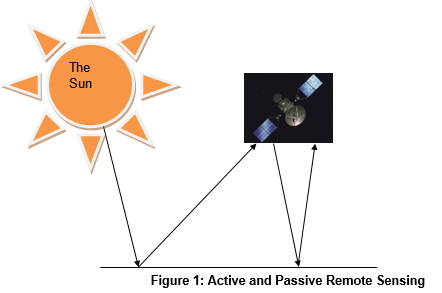
The electromagnetic radiation can be produced by radars, lasers, and sonar techniques.
In active and passive type of remote sensing beams of light can be partially absorbed or reflected, which has a considerable affect on the data quality. This is an inevitable considering interaction of electromagnetic rays with a surface. The prevalence of either process depends on the angle of radiation interaction and its wavelength. However, if the radiation is absorbed, it indicates a high density of carbon dioxide on the investigated area because this gas is considered an efficient absorber (Gibson and Power). With regard to the committee climate change policy, such a quality of carbon dioxide is beneficial because it simplifies its identification.
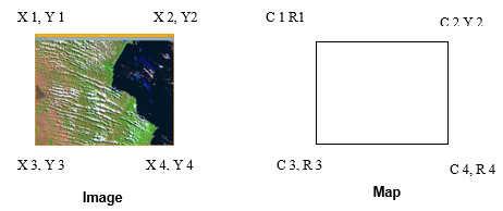
The data quality is closely interconnected with such remote sensing indicators as geometric correction, a projection of remotely sensing images to a map. The point is that remote sensing information is not a map, but a reflected data. Therefore, in order to understand the obtained data, it is necessary to project this data on a coordinate system (Figure 2).
Another important characteristic of remote sensing is radiometric calibrations that identifies the intensity of the received signals. This process implies the conversion of recorded sensors voltages to absolute radiance scale which does not depend on image characteristics. Hence, the surface evaluation directly relies on this process because it influences the accuracy and quality of data (Liang 179). Finally, atmospheric interference should also be taken into consideration because it has tangible impact on the quality of received signal.
Works Cited
Andersson, Krister, Evans, Tom P., and Richards, Kenneth R. National Forest Carbon Inventories: Policies Needs and Assessment Capacity. US: Springer Science, 2006.
Chuvieco, Emilio. Earth Observation of Global Change: The Role of Satellite Remote Sensing. US: Springer, 2008.
Gibson, Paul, and Power, Clare H. Introductory remote sensing: principles and concepts. NJ: Routledge, 2000.
Hassan, Q K., Bourque Conrad P-A., Meng Fangang R., Arp, Paul, MacLean, Dan, and Zhang, Yi. Net Daytime Carbon Dioxide Fluxes Over Eastern Canadian Forests: Application of MODIS Imagery. Faculty of Forestry and Environmental Management. (2006):1717-1720. Print.
Hasselmann, Klaus, Latiff, Mohamad, Hooss, George., Azar, Cecilio., Edenhofer, Ottmar., Jaeger, Carlo. C., Johannessen, Ola. M. Kemfert, Claudia., Welp, Martin., and Wokaun Alexander. The Challenge of Long-Term Climate Change. Science. 302 (2003): 1923-1924. Print.
Khan, M. Ali, Sherieff, A., and Balakishan A. Encyclopedia for World Geography. Sarup and Sons, 2007.
Liang, Shunlin, Quantitative remote of land surfaces. US: Wiley-IEEE, 2004.
National Research Council (U.S.), Steering Committee on Space Applications and Commercialization, National Research Council (U.S.). Space Studies Board, National Research Council (U.S.). Division on Engineering and Physical SciencesRichard C. Using Remote Sensing in State and Local Government: Information for Management and Decision Making. US: National Academic Press, 2003.
Olsen, Richard C. Remote Sensing From Air and Space. US: SPIE Press, 2007.
Schowengerdt, Robert, A. Remote Sensing: Models and Methods for Image Processing. US: Academic Press, 2007.