Summary
One of emergency responders’ primary functions is to protect citizens’ safety and lives when critical situations occur. History knows many examples of such scenarios in which emergency response is vital: hurricanes, tsunamis, earthquakes and volcanic eruptions, wildfires, military strikes, and terrorist attacks. While the list of crises could go on and on, what is essential is that the response must be preventative (FEMA, 2010).
Responsible emergency control agencies, government agencies, and commissioned organizations must develop security management protocols. Critical infrastructure connecting inner-city or national elements is of utmost importance in this planning. This paper comprehensively analyzes critical infrastructure for Sacramento, CA, and the state to anticipate potential impacts and risks.
Overview of Sacramento’s Critical Infrastructure
Sacramento is the state capital of California and is a moderate-sized city. Demographics indicate that the city has a population of just over 528.3 thousand, and the average age of residents is 34.9 years (WPR, 2023). Sacramento is located along the waters of the river of the same name (Figure 1), and one of the significant existing threats to the safety of residents is flooding. The study of the city’s critical infrastructure is preventive and is focused on evaluating only one crossing node, depicted in Figure 1 with a red circle.
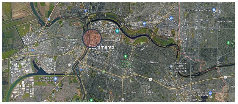
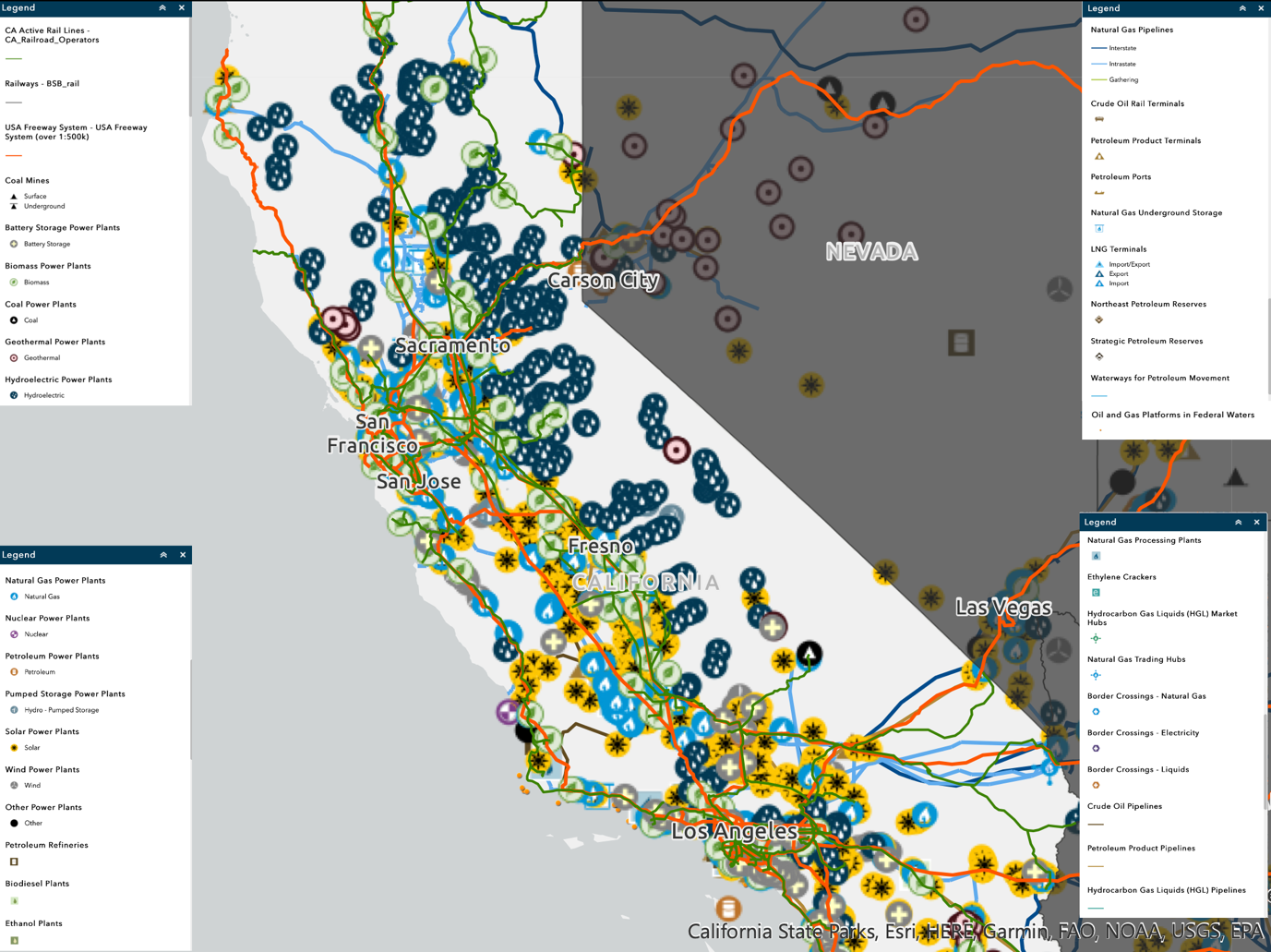
Figure 2 shows the distribution of critical infrastructure elements in California: as the data shows, the state is riddled with highways and railroads, and the primary energy resources are biomass power, natural gas processing plants, solar power, and hydroelectric power plants.
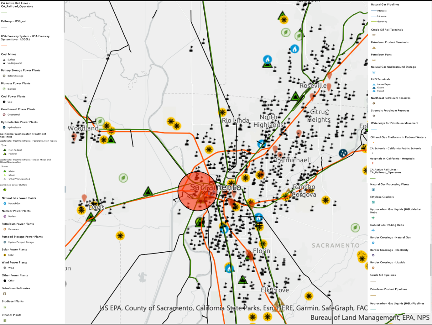
Turning to a more detailed look at the city level (Figure 3), solar power is identified as the municipality’s primary source of electricity and underscores a dozen water treatment plants. Sacramento has a large number of schools (private and public) and a comparably smaller number of hospitals. Railroads and highways are roughly equally distributed in Sacramento.
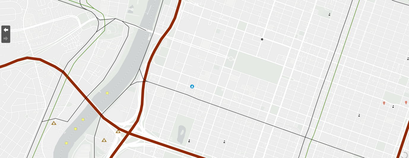
The downtown area directly along the lower Sacramento River is used as the selected node (Figure 1). As Figure 4 shows, this node is crossed by the I5 and I305 freeways (brown line), the railroad right-of-way (green line), and some energy infrastructure, be it three energy product terminals (brown triangle), one DGS central utility plant (blue circle), six schools (black flags), two hospitals (red marks), and four-port facilities (yellow squares). Together, they form a cohesive infrastructure system that, if it fails, can lead to crises.
Potential Failure Scenarios and Infrastructure Risks
From a critical infrastructure perspective, failures are possible at the highway level. I-5 is one of the nation’s foundational highways, connecting Washington, D.C., California, and Oregon. The I-305 freeway represents the interior stretch of road that connects the west and central cities. Disruptions to this facility, whether mass accidents, traffic signal violations, flooding, fires, or other emergencies, pose a danger to road communications. Communication is cut within the city on one of the most popular sections (I-305) and between states on I-5, making it challenging to provide interstate humanitarian support.
Crises can also occur at petroleum product terminals on opposite river sides. These are gas stations with tanks, gas stations, and oil pipelines close to major highways. The occurrence of single failures (e.g., petroleum product fires) can affect the performance of such stations and lead to the shutdown of highways (Arrighi et al., 2019). Significantly, there is a school (The Met Sacramento) near the terminals, about one mile away, so harmful combustion products from petroleum products and/or shock waves from explosions could be detrimental to the safety of schoolchildren.
The railroad tracks are located on the west bank of the hub and run along the river (Figure 4). Emergencies such as train fires or derailments do not directly threaten schoolchildren, but can potentially damage the highway service. In addition, rail crises could cause fires at a nearby gas station (Ramos Oil), which could have the other effects previously described.
Multiple failure scenarios involving multiple infrastructures are also possible. Firstly, the destruction of the facilities themselves causes both material and human casualties, such as workers at these facilities or bystanders. Second, the consequences of a hazardous event (smoke from a fire, destruction of buildings due to an earthquake, disruption of transportation links) disrupt infrastructure communications, complicate access for emergency responders, and result in additional casualties.
A third order of consequence could be, for example, looting if the damage to infrastructure has become significant and there has been a mass evacuation. Any removal of infrastructure will entail intra-nodal changes. For example, removing I-5 and I-305 as the primary means of road transportation would necessitate using alternative transportation options.
Outside of the node in question, east of I-5 is the I-99 freeway. If I-5 is removed, motorists and emergency responders would have to use I-99, which would increase the distance by more than three miles and add more than 3-5 minutes to transport times, given the complex roadway interchanges. Removing the railroad right-of-way would increase transportation times even more, since the alternate parallel track is 5-7 miles away.
To ensure the safety of citizens in case of emergencies, it will be essential to consider alternate travel options if the infrastructure described is damaged. For example, an explosion at a fuel station should prompt the evacuation of nearby schools and homes immediately to prevent children from inhaling smoke. Given the proximity of all infrastructure, moving to the east and north is the best option, as the number of potential hazards is reduced there.
References
Arrighi, C., Pregnolato, M., Dawson, R. J., & Castelli, F. (2019). Preparedness against mobility disruption by floods. Science of the Total Environment, 654, 1010-1022. Web.
CIS. (n.d.). Critical infrastructure sectors. America’s Cyber Defense Agency. Web.
FEMA. (2010). Developing and maintaining emergency operations plans, comprehensive preparedness guide (CPG) 101 version 2.0. Web.
Rinaldi, S. M., Peerenboom, J. P., & Kelly, T. K. (2001). Identifying, understanding, and analyzing critical infrastructure interdependencies. IEEE Control Systems Magazine, 21(6), 11-25. Web.
WPR. (2023). Sacramento, California population 2023. World Population Review. Web.