In 2004, South Asia experienced one of the deadliest tsunamis and earthquakes in history. It was notable for two reasons – its almost unprecedented scale and unexpected nature. Both the scientific community and the governments were taken aback by the natural disaster since the region had not been known as tsunami-prone. The ensuing crisis called for immediate substantial humanitarian assistance, geological studies, and the implementation of warning systems and emergency responses.
Description and Explanation
Tsunamis and earthquakes are intrinsically related, often occurring in sequence. A rupture between the Indian and Burma tectonic plates caused an earthquake with a record high magnitude. “The earthquake induced a massive tsunami responsible for casualties and damages along most of the coasts surrounding the Indian Ocean” (Bletery et al. 5116). The natural disasters affected area over 1200 kilometres and 15 countries in Asia and Africa. The tsunami lasted over seven hours and had waves that reached 30 metres in height. The death toll of the transpired events amounts to at least 227,898 people (Suppasri et al. 3313). Both earthquake and tsunami are listed among the largest and deadliest natural disasters in the world.
Prior Events and Warning Signs
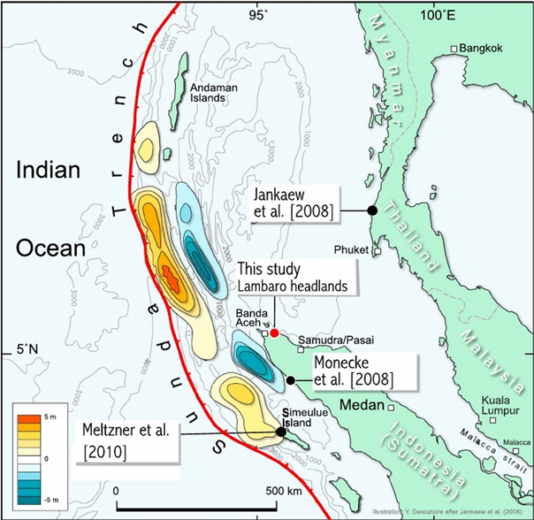
The region was not prepared to handle the disaster, because such disturbances were not an observed phenomenon there. Sieh et al. argue that “records of predecessors existed neither in the cultural memory or written records of communities along the coasts of the Indian Ocean nor in the scientific literature” (308). However, this does not mean that tsunamis had never taken place in the region, as the studies have found evidence of prehistoric tsunamis which are depicted in Appendix A (Sieh et al. 309). The black dots indicate sites of natural disasters that occurred between 1460 and 1300 C.E. As a result, no large-scale water fluctuations were expected around the time of the 2004 tsunami.
In 2004, there were no tsunami warning systems implemented; thus, it resulted in complete regional unpreparedness. Therefore, the most evident sign of the incoming tsunami was the earthquake. Minutes before the strike, the sea receded, which is a typical tsunami warning sign, combined with the shaking of the ground (Hall et al. 482). Due to the absence of evacuation measures, people on the coast were hit by the first wave. Altogether, neither the government nor the population knew what specific signs to look out for because of the lack of adequate tsunami forecasts.
Response and Consequences
The 2004 tsunami and earthquake sent reverberations across the oceans that reached as far as East Africa, yet Asian countries were hit the most. “Indonesia was by far the worst affected country with an estimated total damage of USD 4.5 billion, 167,052 people killed, and 590,684 individuals further affected” (Ismail et al. 439). Hundreds of hospitals, schools, governmental facilities could no longer function. The transport infrastructure was heavily damaged, including thousands of kilometres of road, numerous airports and seaports. Furthermore, devastation left countries without telecommunications sufficient for timely broadcasting of assistance requests. Householding and agriculture suffered from the tsunami, leaving the workforce homeless and unemployed. The impact on human living was so grave the governments established agencies specifically for dealing with restoration efforts, like Agency for the Rehabilitation and Reconstruction of Aceh and Nias in Indonesia.
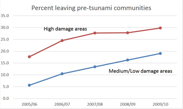
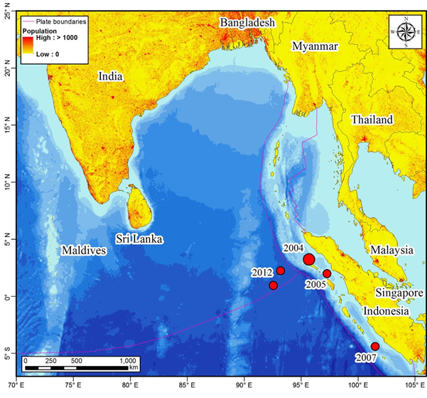
The realization that the region is now susceptible to tsunamis provoked the change in perception of its safety. Appendix B (Frankenberg et al. 4) shows the exodus of the inhabitants of the affected area over the years. The graph suggests the positive correlation between the degree of devastation and the number of people leaving the region. It is also apparent that the more damage the infrastructure suffered, the more population left, with high damage areas getting abandoned by up to 30%. This is also supported by a map in Appendix C (Suppasri et al. 3317). It depicts the low population in density in the areas that were affected by the tsunami. Red dots pinpoint the location of tsunamis that were caused by the 2004 catastrophe, thus encouraging people to migrate.
The government launched a reconstruction program for the affected areas. The magnitude of the disaster provoked diverse humanitarian aid from countries, non-governmental organizations, and corporations. For instance, Srivastava writes that “Charitable organizations constructed many more houses than the government organizations and therefore rehabilitation was achieved at a quicker pace” (200). The international aid included financial assistance, medical supplies, food, clothes, and volunteers. Combined with governmental activities, they rebuilt the area, although a large proportion of the inhabitants chose to immigrate from the shoreline.
Conclusion
Overall, the 2004 natural disaster was a shocking event with numerous scientific, economic, and social implications. The unexpected appearance of tsunami provoked geological research that linked the regional contemporary tsunami vulnerability to the ancient catastrophes. The governments were forced to react and institute proper evacuation and preparation measures. The substantial damage to the area and massive civilian casualties attracted attention and help from the international community in restoration efforts. Meanwhile, the catastrophe served as the catalyst for later tsunamis that were less disastrous in scale but caused the population exodus from high-damage areas.
Appendixes
Appendix A
Appendix B
Appendix C
Works Cited
Bletery, Quentin, et al. “A Bayesian Source Model for the 2004 Great Sumatra‐Andaman Earthquake.” Journal of Geophysical Research: Solid Earth, vol. 121, no. 7, 2016, pp. 5116-5135.
Frankenberg, Elizabeth, et al. “Should I Stay or Should I Go? Long-Term Migration after the Indian Ocean Tsunami.” Population Association of American Annual Meeting. 2017. pp. 1-10.
Hall, Sarah, et al. “Awareness of Tsunami Natural Warning Signs and Intended Evacuation Behaviors in Java, Indonesia.” Natural Hazards, vol. 89, no.1, 2017, pp. 473-496.
Ismail, Nafesa, et al. “Livelihood Changes in Banda Aceh, Indonesia after the 2004 Indian Ocean Tsunami.” International Journal of Disaster Risk Reduction, vol. 28, 2018, pp. 439-449.
Sieh, Kerry, et al. “Penultimate Predecessors of the 2004 Indian Ocean Tsunami in Aceh, Sumatra: Stratigraphic, Archeological, and Historical Evidence.” Journal of Geophysical Research: Solid Earth, vol. 120, no. 1, 2015, pp. 308-325.
Srivastava, Mitashree. “Life and Livelihood in Coastal Community post Tsunami 2004: An Anthropological Case Study of Arattupuzha Village of Kerala.” Development, Resources and Livelihoods, no. 15, 2015, pp. 192-202.
Suppasri, Anawat, et al. “A Decade after the 2004 Indian Ocean Tsunami: The Progress in Disaster Preparedness and Future Challenges in Indonesia, Sri Lanka, Thailand and the Maldives.” Pure and Applied Geophysics, vol. 172, no. 12, 2012, pp. 3313-3341.