Summary of the Primary Paper
The article ‘Improvement of Tsunami Countermeasures Based on Lessons from the 2011 Great East Japan Earthquake and Tsunami- Situation after Five Years’ focuses on measures that should be taken to deal with similar disasters in future. The goal of the article is to eliminate or significantly reduce casualties when the city suffers another tsunami. The 2011 tsunami was a major natural disaster in Japan with devastating consequences.
According to the finding by Suppasri et al., the incident exposed major weaknesses in the country’s preparedness to deal with tsunami (1). Before the incident, Japan was considered one of the nations which are well equipped to deal with a tsunami disaster. However, its countermeasures failed to protect lives and property in 2011. The disaster led to 15,896 deaths while another 2,537 people went missing. Many others sustained varying degrees of injury while properties worth billions of dollars were also lost.
The lesson learned from this incident was a clear demonstration that actions must be taken to ensure that coastal residents are protected from tsunami and related natural disasters. The article focuses on what can be done by the government and private investors to enhance the safety and security of those living in areas prone to such incidents. It is important to note that although the study focused on Japan, the measures can be applied in any other country that faces similar threats such as Canada and the United States. This paper will critically review the article by Suppasri et al. with a view to analyzing and interpreting the text (4).
The paper concludes by reiterating the importance of proper planning when it comes to mitigating consequences tsunami. This primary article could have been improved by looking at the role of non-governmental agencies during rescue missions.
Critical Review of the Primary Paper
Numerical Tsunami Simulations
One of the major issues that this article focuses on is the numerical tsunami simulation as a way of planning for the disaster (Goda et al. 30). The devastating impact of the 2011 Japan earthquake and tsunami made it necessary to develop simulations as one of the countermeasure strategies to deal with similar disasters. In this article, the author describes the relevance of numerical simulators, an outcome of a state-of-the-art research, to help in determining consequences of tsunami and the manner in which the government can deal with it.
The idea is supported by Harbitz et al. who argue that the 2011 earthquake and tsunami “caused damage along the entire east coast of Honshu” (16). As such, measures are needed to deal with such eventualities. A team of experts came up with numerical modeling codes such as MOST (Method of Splitting Tsunami), TUNAMI (Tohoku University’s Numerical Analysis Model for Investigation of Near-field tsunamis), and JAGURS (Japan Agency Geoscience United Research Services) to help with the investigation of the impact (Suppasri et al. 3). The article focuses on TUNAMI, an improved model of TIME (Tsunami Inundation Modeling Exchange) that was developed in 1995 by Tohoku University (Suppasri et al. 3).
TUNAMI-N1 refers to a constant grid tsunami simulation that uses linear long-wave theory to investigate wave propagation in deep seas (Suppasri et al. 4). The simulation has gained popularity from Japan to Europe and North America. TUNAMI-N2 uses the same linear theory but assesses the wave on land and shallow waters. TUNAMI-N3 on the other hand, is a numerical model that uses nested-grid alongside a linear theory to assess tsunami waves. These models gained popularity after the 2011 Japan earthquake and tsunami. It became necessary for the disaster preparedness and management team in Japan to have a clear numerical and theoretical model that makes it easy to understand the impact of similar disasters and the patterns they are likely to take on land.
Having high-resolution simulations helps in determining factors such as depth and velocity of the displaced water (Goda et al. 30). The information is useful in developing estimation of the destruction capacity once it hits the land. However, Harbitz et al. note that “information on the performance of rubble mound breakwaters are lacking since they are less common in Japan” (8). The issue needs to be addressed. Through the simulation, it becomes easy to determine the impact it will have on buildings and people living within a particular distance from the land. One can determine structures that can survive the impact.
Understanding the landscape of the given area of interest also helps in planning rescue and evacuations. The simulation outlines the water paths depending on its depth and velocity (Kennedy et al. 11). The rescue team can understand areas that will remain relatively safe when tsunami strikes and locations that must be avoided. When developing awareness campaign, the team will have clear information about areas where the impact will be greatest, and what residents of such areas should do to minimize loss of property.
Suppasri et al. explain that when tsunami strikes, geomorphological changes are expected to occur (6). Sediment transportation is expected to occur within a given region that is affected, especially if the velocity is high and the water movement last for a considerably long time. The simulation model helps in identifying factors that define the magnitude of sediment movement. They include initial wave amplitudes, the slope of the beach, and grain size.
The argument is supported by Zhang who state that the movement of soil particles during a tsunami wave is defined by factors such as the nature of soil, the slow, and speed of the wave (164). The information makes it easy for the disaster management team to understand the expected consequences of the tsunami with regard to sediment transportation. Massive sediment transportation often complicate rescue missions as victims end up getting buried in the soil before they can be rescued. It also complicates the cleaning process. As Goda et al. state, having a numerical tsunami simulation is one of the most significant developments arising from the 2011 Japan earthquake and tsunami (32). These concepts have been embraced in North America and Europe.
Building Damage Assessment
Numerical simulation is increasingly becoming a popular method of enhancing coastal planning and research (Liu 12). The concept of tsunami fragility function has gained popularity in expressing the probability of a building to exceed a predetermined damage state for specific tsunami intensity (Suppasri et al. 5). Using least square linear regression analysis, this concept helps in determining the ability of various buildings to withstand tsunami wave.
The 2011 tsunami that affected East of Japan and the 2004 Indian Ocean Tsunami that hit Thailand and Indonesia made it necessary for coastal planners to redefine structures that can withstand the wave. The type of materials used in these structures, their shape, and height all play a role in determining their fragility. It is necessary to take into consideration geographical factors within the coastline when planning the settlements. Where structures are erected strategically to reduce the force of water flow, it increases the capacity of nearby structures to withstand the force. On the other hand, a sloppy bear land makes such structures susceptible to the force of the displaced water.
The tsunami fragility function has become relevant to various countries that also share the risk of tsunami strikes (Harbitz et al. 18). Thailand and Sri Lanka have embraced this model in their coastal planning. The recent events in Chile and parts of the United States have also forced the local authorities to find better ways of planning settlement in the coastal region. Building codes and civil engineering practices may differ from one country to another based on technological advancements and other factors.
As witnessed during the 2011 Japan earthquake and tsunami, some buildings were able to withstand the force of the displaced water while many others were not (Suppasri et al. 8). Many lives were saved by the fact that these buildings offered refuge to many people. The model can be used to define the type of structures that should be located closest to the water body and those that need to be several meters if not kilometers away from the beach based on the topography and susceptibility to tsunami strike.
The concept of reinforced concrete (RC) buildings has also become popular in coastal planning as a way of ensuring that people can be safely evacuated and offered proper shelter during a tsunami strike (Harbitz et al. 18). The article discusses the need to reassess RC buildings, especially residential apartments, hospitals, schools, and hotels. These buildings proved vital during the 2011 East Japan Tsunami as they offered refuge to thousands of people (Suppasri et al. 4).
As such, they should withstand the pressure exerted by the displaced water. These institutions should be reassessed to determine their capacity to withstand stress exerted by the force of water. The architects and civil engineers should also remember that in such cases of emergency, the buildings might have to hold greater than normal capacity. For instance, a classroom meant for 40 students may have to hold 70 or more people. The structural designs of such buildings should be strong enough to avoid a possible collapse. The designers should also understand that in such circumstances, more people (greater weight) will be on the higher floors for safety reasons, and as such, the design should reflect these possibilities.
Coastal Defense Structures
It is not easy to have a precise prediction of when or how the next tsunami will strike. However, it is the responsibility of the stakeholders involved to develop proper security measures to ensure that human lives and properties are protected from this natural phenomenon. According to the article by Suppasri et al., one of the most common coastal defense structures is coastal embankments (11).
These structures are meant to prevent the overflow of the displaced water into areas inhabited by people. Unfortunately, these structures failed miserably during the 2011 tsunami in Japan. Overtopping and scouring of the unarmored heal of embankments were the two main reasons why this defense structure failed. Water was able to rise above the structure and in some cases; it came down due to the force of water.
These structural errors need to be addressed when redefining the coastal defense (Mase et al. 4). The height and strength of these coastal embankments need to be reevaluated based on recent failures in Japan and other parts of the world.
Regions such as the Pacific cost of Tohoku are at high risk of tsunami strike and this defense system should be strong enough to prevent or significantly delay the overflow to create time for rescue. Figure one below shows how the heel on the landward side should be strengthened to withstand the force. The joints between armor sections should be improved to ensure that the whole structure remains intact despite the pressure exerted by water.
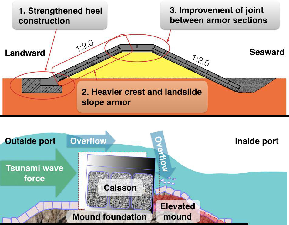
Breakwaters are meant to offer protection to boats and other sea vessels at the harbor during tsunami strike. The 2011 tsunami in Japan demonstrated the level of ineffectiveness of the breakwaters as they failed to control the flow and speed of the surging waters (Suppasri et al. 8). The investigation revealed that the failure was caused by caisson sliding. Mase et al. strongly recommend strengthening of these structures to ensure that they do not curve in to huge waves (6).
It may be impossible to avoid the overflow in some extreme cases of tsunami but if these structures are properly designed, they can slow the movement of water and ensure that the spillage has insignificant force that cannot have devastating impact on lives and properties along the coastal line. The new design of T-walls has been tested in simulated settings has proven effective in managing intense flow of water.
Coastal Forest
The article by Suppasri et al. outlines important lessons from the 2011 tsunami in Japan (12). One of the glaring weaknesses of the coastal defense systems in the poorly designed structures and absence of forest/green cover to help reduce the force of water (Wang 171). As such, Japan Federation of Construction Contractors came up with a proposal of the appropriate design of structures along the coastal lines known to be susceptible to tsunami. The multilayer tsunami countermeasure is meant to ensure that the impact of massive water displacement does not have any significant impact on lives of people living along the coastal region. As shown in figure 2 below, the proposal introduces several safety layers meant to protect lives and property.
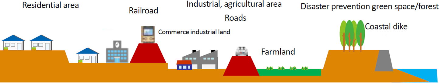
The proposed multilayer design emphasizes the need to ensure that the speed of the flowing water is reduced as much as possible. The first layer of defense is the coastal dike, as shown below. The dike is meant to stop the surging water from overflowing inlands. Strengthening them reduced the probability that they will fail (Mase et al. 11). In case the amount of water is significantly high and cannot be stopped by the dike, this structure will delay the overflow and regulate its speed once it finds its way into the inland.
The next layer of security is the coastal forest cover. The trees and other vegetative cover will help in slowing the speed of the flow. It will ensure that the tsunami is less dangerous to the people living in the area. The third cover is the farmland.
Suppasri et al. explains that sometimes the overflow is not strong enough to go past this point (16). When the crops grown on this farmland can withstand the seawater, it will be of benefit instead of becoming a disaster. If the flow is strong enough to go past this point, the farmland is expected to reduce its velocity. The road is designed to act as the second dike when dealing with a violent wave (Kennedy et al. 20). Water flowing inland will flood the farmland in a delaying tactic meant to create more time for evacuation. The road will further slow the movement of water. The next section will be the commerce industrial area. People should be evacuated from the area as soon as it is determined that the tsunami is too strong to be stopped by the first four layers of tsunami countermeasure.
The railroad is the firth major countermeasure. As shown in the figure above, another major dike should stop further flow of water inland. It is higher than the first two dikes and it is strengthened to withstand the force of water. In case the force is too strong, then the tsunami will finally hit the first residential area. As shown above, the first phase of the residential area should be tall buildings properly reinforced to withstand surging seawater.
Weaker structures should be developed on higher grounds where they are safe from any significant impact of tsunami. In this multilayer tsunami countermeasure, it is rare for the tsunami to hit the residential area. The simulated tsunami cases show that in most of the cases, the impact may not go beyond the road. If it does, then the railroad will be the final point that the water will reach, irrespective of its speed. Anything beyond that point will be an unprecedented catastrophe.
In the city of Tokyo, Millennium Hope Hills were introduced to help in the evacuation in cases where it is established that the multilayer countermeasure proposed above is inappropriate. In this case, only one dike exists whose height can be adjusted as necessary when it is established that a tsunami strike is inevitable. In this case, an artificial canal is created to help channel the water into a given path. An artificial hill is also created specifically meant for the evacuation.
As soon as the alarm is sounded, everyone is expected to rush to the hill with movable valuables that can be rescued under such short notices. The fortified hills are meant to offer security to the residents for a given period before they can be transferred to safe grounds if there is a total destruction of the city. These extreme measures are meant to minimize deaths as much as possible. The simulations show that the 2011 tsunami that affected East of Japan would have resulted into fewer deaths were it that such countermeasures were put in place (Goda et al. 27).
Warning and Observation Systems
Effective warning can help save lives and make the work of evacuation during such disasters simple. One of the factors blamed for the thousands of deaths during the 2011 tsunami in Japan was the inability to take the warning seriously. On March 11, 2011, at around 14:49 JST, the Japan Meteorological Agency (JMA) issued a warning about the impending tsunami three minutes after the earthquake (Suppasri et al. 16).
The warning categorically stated that Iwate Prefecture would have a tsunami height of 3 meters, Miyagi 6 meters, and Fukushima Prefecture 3 meters. The data collected from the Ports and Harbor Bureau GPS indicated an abnormally rapid changes in the sea level and JMA further updated its warning at 15:10 JST. The agency continued to issue warning based on the observations made. The records indicate that JMA issued warnings seven times before the disaster struck (Suppasri et al. 16).
Despite the numerous warnings, many people were still at places that had already been classified as dangerous because of the expected flow of displaced water. Most of those who lost their lives had failed to take the warning seriously. They waited until it was too late for them to be rescued. Their fate was sealed as the seawater raged through the streets and into various structures.
According to Goda et al., the inability of people to take the warnings seriously and evacuate the stated areas was partly blamed on JMA (16). The broadband seismic data saturation made it difficult to calculate the Mw value in time, and as such, the forecast tsunami height was dangerously underestimated. Most of the areas put on red-alert actually received tsunami heights tice or more what had been predicted. Many people made the decision to stay after the initial estimates because they believed they were on safe grounds. The journal criticizes the system for failing the people. By the time the reality downed on the victims, it was too late for them to be rescued.
A good number of them were swept along the streets trying to rush to safer grounds after realizing that the warning issued did not give accurate estimates of the magnitude of tsunami. Another consequence of the underestimated height and strength of the tsunami was that it hampered rescue mission. The disaster management team had prepared to deal with a less powerful wave of seawater on the lower part of the city. However, that was not the case. Most of the roads that the team was prepared to use were submerged, and the equipment could not withstand the pressure. The rescue team could not do much to save those who were trapped in dangerous locations.
Following the events of the 2011 tsunami, it became evident that the earning strategies had to be redefined to eliminate instances where many lives are lost as was in the case in the past. The basic policy stated that tsunami warnings must be disseminated as soon as possible (Suppasri et al. 18).
Under this policy, JMA is expected to pass the warning based on the worst possible scenario to ensure that people take it seriously. As Zhang argues, it is better to prepare people for the worse than to underestimate the impact (163). In case the magnitude of tsunami subsidizes, they can be informed about the same. People in the affected area may be affected by the loss of time, but they will be safe in case the forecasted tsunami has serious consequences.
The taskforce formed after the 2011 tsunami also recommended technical improvements on detecting tsunami. As shown in this report, accurate prediction of the possible behavior of tsunami on land makes it easy to develop countermeasures. A 5-m-grid inundation simulation can help to determine the impact of the tsunami on roads and residential areas based on the measured magnitude (Goda et al. 29).
The team can determine parts of the coastal area likely to be affected the most. Finally, the team also advised on the need to create awareness of tsunami among the locals as part of disaster preparedness and management. Sometimes people die because of ignorance and curiosity. Even after a warning is issued, they remain in danger zones because of the desire to see tsunami without understanding the impending danger. Awareness campaigns will enable them to understand the threat and the need to take immediate actions as soon as a warning is issued.
Inland and Offshore Evacuation
When it becomes apparent that a tsunami is going to strike a given region, JMA recommends immediate evacuation. As shown in this article, there is the inland and offshore evacuation. Each takes different approaches (Suppasri et al. 22).
Inland evacuation involves taking people away from the beach and buildings expected to be affected by the massive flow of water. A report prepared by Fire and Disaster Management Agency show that vehicular evacuation is the most common means of escaping from tsunami wave. People wait until last minute, and when it becomes apparent that their premises will be affected, they rush to their car to reach safety grounds. The problem with this strategy is that sometimes it results into a serious traffic gridlock.
The haphazard movement of cars, sometimes to an unspecified destination and lack of traffic control means that major roads can be locked within a short time. The impact is that the evacuees will be trapped on the highways. Such a case was witnessed in Ishinomaki City as tried to escape the waves in different directions using their cars, with limited time to spare. Vehicular evacuation is currently discouraged, unless it is unavoidable, such as when evacuating children and the elderly. Instead, people are encouraged to heed the warnings and walk to safety early enough to avoid stampede. In Miyagi Prefecture, a new program called Kakeagare is being popularized, which involves running to safer grounds in cases of disaster.
Offshore evacuation is as important as onshore evacuation, but it is a little more complex. When tsunami is evident, it is often advisable for offshore evacuation teams to ensure that their vessels are on safety zones of 50m or deeper (Suppasri et al. 16). In such region, the impact of the tsunami tends to be negligible and experts can easily survive. Moving in such zones within the shortest period will ensure that the evacuees and their vessels will be safe from the impact. If the location of the evacuees is far from the safe zones deep into the sea, then it is advisable to move towards the inland as fast as reasonably possible and join the inland evacuees to safer grounds.
Conclusion
The 2011 Great East Japan Earthquake and Tsunami had devastating impact on the coastal towns, which were affected. Thousands of lives were lost many were injured, while others have been missing. Properties worth billions of dollars were lost in the process. This article outlines major lessons learnt during and after the disaster. The incident identified major weaknesses on Japan’s capacity to deal with such disasters.
It was evident that although the country had been viewed as a global leader in dealing with tsunami, it was not ready to handle huge scale surge of water into the coastal city. The article outlines a number of measures that should be taken to ensure that lives and properties are safe. A countermeasure coastal planning design that is proposed is meant to help in managing the height and velocity of the overflow during tsunami. The article proposes new codes of construction that should be embraced by the coastal urban planners to improve strength of structures along the coastal line. The importance of timely tsunami warning and evacuation are also discussed to enhance safety of people and property.
Works Cited
Goda, Katsuichiro, et al. “New Scaling Relationships of Earthquake Source Parameters for Stochastic Tsunami Simulation.” Coastal Engineering Journal, vol. 58, no. 3, 2016, pp. 1-38.
Harbitz, Carl, et al. “Risk Assessment and Design of Prevention Structures for Enhanced Tsunami Disaster Resilience (RAPSODI)/Euro-Japan Collaboration.” Coastal Engineering Journal, vol. 58, no. 4, 2016, pp. 1-30.
Kennedy, Andrew, et al. “Observations and Modeling of Coastal Boulder Transport and Loading during Super Typhoon Haiyan.” Coastal Engineering Journal, vol. 58, no. 1, 2016, pp. 1-23.
Liu, Huiru. “Numerical Simulation of Marine Internal Wave Dynamics Based on Functional Analysis.” Journal of Coastal Research, vol. 1, no. 83, 2018, pp. 12-16.
Mase, Hajime, et al. “Analysis of Climate Change Effects on Seawall Reliability.” Coastal Engineering Journal, vol. 57, no. 3, 2015, pp. 1-17.
Suppasri, Anawat, et al. “Improvement of Tsunami Countermeasures Based on Lessons from the 2011 Great East Japan Earthquake and Tsunami- Situation after Five Years.” Coastal Engineering Journal, vol. 58, no. 4, 2016, pp. 1-23.
Wang, Feng K. “Investigation and Evaluation of the Ecological and Geological Environment Quality of High-Efficiency Ecological Economic Zone (HEEEZ) Coastal Regions within the Yellow River Delta.” Journal of Coastal Research, vol. 1, no. 84, 2018, pp. 169-180.
Zhang, Jinliang. “Estimating Sediment Moving into the Yellow River Based on Moving Process Analysis.” Journal of Coastal Research, vol. 1, no. 84, 2018, pp. 163-168.