Abstract
The main aim of the paper is to categorize and classify the different forms of the made grounds. As made grounds are a category of the artificial man-made ground, the paper first delineates the different areas of the artificial ground and how the made ground can further be classified. The paper presents the different forms of made ground and their classification based on the BGS scheme.
Introduction
The availability of information regarding man-made ground in an urban environment has gained importance in recent years. Geologists, to study their redevelopment, are placing importance on towns and cities. The requirement is to understand the properties of naturally occurring deposits that lie superficially on the surface. Apart from that, the aim is also to analyze the characteristic of the superficial depositions and the anthropogenic processes.
The terrain consists of holes on the ground along with other materials. Mining of the ground and other quarrying activities derive the characteristic of the terrain (McMillan & Po 1999). Industrial processes and modernizations have created derelict grounds that have increased the propensity of geo-hazards like an earthquake, pollution of groundwater and soil (BGS 2013; Heathcote, Lewis & Sutton 2003). All made grounds are assessed in order to provide information to the authorities to aid in the planning process (Rosenbauma et al. 2009). Most researchers have concentrated on analyzing the made ground in urban industrial areas like ‘brownfield’, ‘inner city Greenfield’ and ‘urban ring Greenfield’ (Rosenbauma et al. 2009). This data is usually stored in the National Geological Survey database (Rosenbauma et al. 2009). In order to ensure a consistent knowledge of the geological material, schemes should be created for natural debris like rocks and sediments (Rosenbauma et al. 2009). The paper will discuss the various ways in which the made surfaces are classified and characterized.
Mapping of Artificial Ground
Mapping of the made ground in the field of geology requires the identification of the landform by the geologists. The process in which the sequences are arranged helps in understanding the origin of the deposits, which in turn helps in developing the map. Lithographic profiling of the area helps to develop a database that provides information regarding the temporary cuttings of the surfaces.
Usually, multiple techniques are used to determine the nature of the origin of the debris (Rosenbauma et al. 2009). For instance, in the case of landforms that are mapped on the ground as well as datasets available remotely, it can be seen that the information available on the character of the surface of the ground is limited in the remote dataset. Very little information is provided on the texture, composition, and lithology of the deposits on the ground. However, lithographic characters provide sufficient information about the surface of the boreholes and trial pits. They also demonstrate the true composition and texture of the debris (McMillan & Po 1999). However, they do not provide sufficient information regarding the origin of the deposits (Rosenbauma et al. 2009). Hence, the theory that systematically subdivides the artificial grounds based on the texture and the genetic composition of the deposits is infrequently possible.
Another method that can be used to study the artificial ground and the superficial surface is the genetic approach. The main way of classification of the deposits is by the nature of deposits and the origin of the artificial deposits on the surface. Geologists create a graded system in order to link primary genetic classes as Level 1, the basic classes as Level 2, and exhaustive classes as level 3 (Rosenbauma et al. 2009). The three levels are broadly categorized as the unit of formation for the deposit classification scheme. They are incorporated into the BGS lexicon system. Level 4 of the categorization relates to the lithology of the deposit and is used in the process of morpho-stratigraphical divisions in levels 1 and 3. In case of a map that is fully attributed, it is important to understand that the BGS coding scheme helps to allot level 2 entries into the morpho-stratigraphy, and level 4 is inserted in lithography (Smith & Ellison 1999). The level four schemas for lithography are available in the BGS schema. Sub-divisional codes for level 3 are being prepared and the lithographical classifications can further be revised in the future. Cross-references are required by the scheme that helps in identifying obsoletes. Textural information common for the genetic classes is also available to the sub-divisions that may provide other physical information.
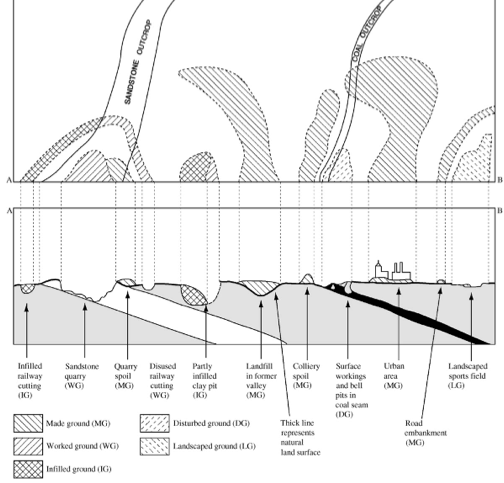
Classification of Made Ground
BGS provides a detailed classification of made ground, which has been prepared over a 50 years period. The classification comprises of the following: “worked ground, made ground, infilled ground, landscape ground, and disturbed ground” (Rosenbauma et al. 2009, p. 403). Figure 1 presents the above categorization. This category presented in the paper comprises of both man-made deposits as well as other forms of debris that can be classified as voids, which usually signifies areas that are queried for mining purposes. These categories help in the mapping scheme developed by BGS. The mapping categories are made based on the following definitions:
Made Ground: The areas where the grounds have been found to consist of artificial deposits on the natural ground surface are called made ground. These areas may consist of engineered areas like road and rail works, reservoirs, and embankments. Other areas where this type of ground may be found are waste heaps, coastal reclamation fills, and offshore dumping grounds.
Worked Grounds: The region, which has been cut away by roads, mining activities, and railroads, is often termed as worked grounds.
The infilled ground is an area, which has been formed by artificial landfilling and quarrying activity. However, the natural ground on the surface of the land rises due to artificial deposits. The categorization of the infilled ground is being reviewed by BGS and the modeling is done on the scale of 1:10000 or greater. The characterization of the infilled ground requires refereeing two datasets (McMillan & Po 1999).
Landscape ground is the remodeling of the original surface by natural and/or artificial means wherein the original surface is greatly transformed.
Disturbed ground: Areas of the surface, which have been modeled by minerals and are not clearly defined due to excessive excavation, are called disturbed grounds. These areas are usually ill-defined and the excavations are man-induced. Usually, this is caused by human beings’ activities such as shallow mine workings, for example.
Fill and waste material is further classified based on the type of material. Chemical and inert material often create the composition of the deposits on the ground (McMillan & Po 1999). The nature of the fill differs based on the direction i.e. it is different both vertically and horizontally. These are mostly found in landfill sites, which are not monitored, or the areas of landfill without any official record. The process of on-site investigation of the boreholes and other fills determines the characteristic of the fill (McMillan & Po 1999). According to the UK regulations of waste classification measures, (DETR/EA 1998) jointly produced by the Environmental Agency, it is pointed out that the reduction of fill and waste materials on the ground surface should be classified throughout the nation following a single format. Price et al. (2011) pointed out that the geological and geomorphological composition of the ground reflects the changes that have occurred on the natural ground. Therefore, it is important to reflect properly on the composition of the made ground. Usually, these are created through excavation and other human activities. Price et al. (2011) points out:
The geological and geomorphological impact of these changes is reflected in the deposition of made ground, removal of material through excavation, enhanced denudation through agricultural activity, and the disruption of natural sediment transfer through dam construction, for example. The former two processes represent the deliberate actions of humans to extract, transfer, re-use, or discard rock, soil, and man-made materials. This contrasts with the latter two processes, where the impacts on sediments and sediment transfer are the unintentional consequence of anthropogenic processes where the movement of sediment was not the primary objective. (Price et al. 2011, p. 1061)
The waste is classified into three levels. The first level comprises inert material, biodegradable waste material, metals and scraps from junkyards, general substances that are contaminated, other wastes that may cause health hazards, asbestos, mineral wastes, and industrial residues, inorganic chemical waste, organic chemical, mixed material, and radioactive waste (Makedon, Chatzigogos & Spandos 2009). The landfill sites are classified based on the following: sites that are hazardous, non-hazardous sites, and areas that comprise of inert waste materials.
The landfill areas are defined as contentious problems after classifying them into various categories. An analysis from the historical perspective shows that it is the best practice to record only that debris that can be classified and proven and the ones that are of uncertain origin should be recorded as “undifferentiated” (Rosenbauma et al. 2009). In certain urban areas, artificial waste is analyzed by the local authorities. The European Community (EC) has also categorized waste materials as hazardous, non-hazardous, and inert wastes (Rosenbauma et al. 2009).
Conclusion
The paper has discussed the various characterizations of made ground. The paper provides the properties and basis of classification. The graphical representations of the deposits are done by BGS with the aid of a scale of 1:10000 and 1:50000. This is done with the help of geographical maps of various shapes and styles. Colors are used to demarcate the different forms of debris and such maps can be digitally generated. The boundaries are demarcated with fine and dashed lines and the scale standard is 1:10000 (BGS 1995). Finally, deposits on made grounds may be classified based on the following characteristics (Rosenbauma et al. 2009):
- Level 1: the origin of this ground is artificial and it remains undivided throughout.
- Level 2: for this categorization, users may derive information from the analogous geological map (Forster et al. 2004).
- Level 3 occurs at the stage where the better records are stored and the different types of made and fill grounds can be identified.
References
BGS 2013, Artificial (man-made) theme, Web.
BGS 1995, Specification for the preparation of 1:10,000 scale geological maps, 2nd and, British Geological Survey, Nottingham.
DETR/EA 1998, The UK Waste Classification Scheme, HMSO, London.
Forster, A, Lawrence, DJD, Highley, DE, Cheney, CS & Arrick, 2004, ‘Applied geological mapping for planning and development: an example from Wigan, UK’, Quarterly Journal of Engineering Geology and Hydrogeology, vol 37, no. 4, pp. 301-315.
Heathcote, JA, Lewis, RT & Sutton, JS 2003, ‘Groundwater modelling for the Cardiff Bay Barrage, UK–prediction, implementation of engineering works and validation of modelling’, Quarterly Journal of Engineering Geology and Hydrogeology, vol 36, no. 2, pp. 159-172.
Makedon, T, Chatzigogos, NP & Spanos, S 2009, ‘Engineering geological parameters affecting the response of Τhessaloniki’s urban fill to a major seismic event’, Engineering Geology, vol 104, no. 3, pp. 167-180.
McMillan, A & Po, J 1999, ‘Classification of artificial (man-made) ground and natural superficial deposits applications to geological maps and datasets in the UK’, Rock Classification vol. 4, BGS Rock Classification Scheme, British Geological Survey, RR 99–04., NECR, Nottingham.
Price, SJ, Ford, JR, Cooper, AH & Neal, C 2011, ‘Humans as major geological and geomorphological agents in the Anthropocene: the significance of artificial ground in Great Britain’, Philosophical transactions of the royal philosophical transactions of the royal society a-mathematical physical and engineering sciences society – mathematical physical and engineering sciences, vol. 369, no. 1938 , pp. 1056-1084.
Rosenbauma, MS, McMillan, AA, Powell, JH, Cooper, AH, Culshaw, MG & Northmore, KJ 2003, ‘Classification of artificial (man-made) ground’, Engineering Geology, vol 69, no. 3-4, pp. 399-409.
Smith, A & Ellison, RA 1999, ‘Applied geological maps for planning and development: a review of examples from England and Wales, 1983 to 1996 ‘, Quarterly Journal of Engineering Geology and Hydrogeology, vol 3, no. 2, pp. S1-S44.