Abstract
The proposal has a high degree of potential strengths regarding to the subject for the development of this Historical Reconstruction of our ecology. On this issue of project formulation the very key ingredient missing on the other hand requires my devotion preliminary commentary to suggest the definition of necessary involvement. Different ways for the approach to the carrying out this project may be applied to the underlined fictional scenario. With the obligation of being in charge of the current land use assessment and environmental issues in the Oregon’s’ river basin, a wide-ranging recommendations about how and why to proceed with a particular program of restoration has to be verified.
This has therefore indicated that “the duo concepts needed in essential definition of the re-establishment goals of river restoration are, a reference condition to define the restoration goals themselves (often taken as a natural, pre-anthropogenic disturbance state) and a process-based appreciation of how to attain the laid down goals. Usually one can be able to utilize the surficial geologic record information on procedures of trying to use the laid preventive measures in averting ecological effects thus ideas brings about the construction both of the concepts. On the same description we give the explanation of what is meant by some of these concepts, but focus on the clarity of the fact that the kind of information already proposed is truly examined in this assignment and is fundamental. An enlightenment of the thesis clarification is therefore purposeful and in this paper, in the conservation purposes there is need for the prevention of un-purposeful deforestation and regulation of river waters for irrigation and other man-made utilization of available resources.
This lays down the valuable significance of the information in many ways, for instance, DRC program will enlarge riparian areas outside federal guiding principles and ensure the trees are maintained for at least 50 years (Oregon Department of Fish and Wildlife 2009) and the target is that, by 2008 1500 to 1800 acres of riparian environment will be restored and vigorously sequestering carbon.
This would lead to changes in the geomorphic features and affected land use requirements or convenience, and describes the way riparian area is altered by these land use requirements. These matters are integrated meaningfully in giving conclusion which gives a particular assessment of environmental conservation programs such as these ones. It is necessary to give a proposal that through implementation of these targets, one can highly improve the rate of restoration of these environments.
Introduction
The concept of restoration of our ecosystems of the river banks has been a perennial issue, in the world for example in the Western areas of the United States. This historical ecological damage has encouraged the invention of ways through which notable changes can be made to safeguard the good ecology environment, through formulation of given legislation in order to determine how the resources in the river banks. This defined that the use of river waters should follow the in stream flows regulation, a factor which led to an idea of states having a claim on the allocation of waters not in use in the river (Livingston and Miller; McKinney and Taylor). For instance in the case of the Deschutes River Conservancy (DRC), program that helps landowners in the Deschutes River Land basin afforest denude riparian areas with a cover of the indigenous vegetative cover along the Oregon major streams (Mathias, 2003).
In Oregon forest where there is a development of conservation efforts a lot of factors facilitating the degeneration have been taken into consideration, and using this as a theme, this paper seeks to explain the fact that improper land use and deforestation along the river basins are the major causes of ecological disintegration.
Agriculture and other man made activities are highly related to the environmental issues of a community. In the foundation of reversing these ecological devastation one has to consider how the running surface streams can be restored, as this will be the target for sound conservation of land resources. In order to achieve this re-establishment of a river requires two vital concepts that is giving a indication stipulator defining renovation goals which often is taken as a natural, pre-anthropogenic interruption status, and a process-based consideration of ways through which these targets can be attained. The information to define these goals and effects on environmental conservation principles by reforestation, can give the surficial geologic record can be used to construct both of these concepts.
The River
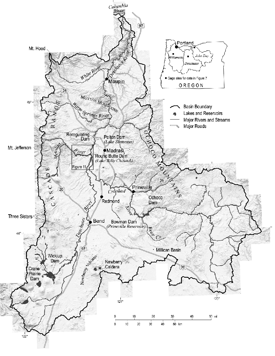
The Deschutes River, a major tributary of the Columbia River, is found in central Oregon and it drains the eastern side of the Cascade Range. The river has a lake Billy Chinook formed by the manmade Round Butte dam. It is located between the flanks of the Cascade Range in central Oregon and the Ochoco Mountains; it flows north draining about 27,000sq.km. As it flows past the community of Sunriver, and into the city of Bend, much of the water is diverted for irrigation; this greatly reduces the volume of water leaving the city through the river. It is estimated that as much as 97% of the water is diverted to the farms for irrigation during summer.
The river goes ahead to carve a gorge through the central Oregon desert that is up to 300 feet below the surrounding plateau in some areas. The drainage basin of the river has been shown to have in the past covered by shallow seas. Additionally, the area was reshaped by volcanic activity. The central Oregon plateau is formed by vast amounts of lava that have formed layers. Most of the rocks that the river has carved through are therefore volcanic. About 1-4 million years ago, the Deschutes canyon formed through a series of volcanic and tectonic activities. The river basin itself is formed with igneous, sedimentary and metamorphic; their ages range from 1300 years to 250 million years. The periodical flooding and water erosion of the rocks coupled with the Missoula floods have all played a part in the current outlook of the river; this was during the glacial periods. The river has a unique feature of being uniformly flowing; this is unlike most of the other rivers of its size in the US.
Following the diversion of most of the water from the river, there have been severe ecological changes on the riparian ecology. Some of the natural flora and fauna have suffered heavily from this diversion. Additionally, farming along the riverbanks has led to denuding of the area. The effect of this has been severe soil erosion along the riverbank; tonnes of silt end up in the river every year.
Additionally, when the volume of the water reduces in the river course, the temperature of the water rises with adverse effects on the population of fish in the affected area. The agricultural requirements for water are enough to dry up the section between Bend and Lake Billy Chinook (Bureau of reclamation), but the farmers have agreed that during the irrigation season they will leave 30csf of water during the dry season. The situation has been made worse by the reduction of the amount of snow feeding the river on the mountain ranges due to effects of global warming.
The total supply of water in the river is not an issue because spring recharge completely restores the volume of the river before it empties into the Columbia. This is due to the return of the leeched water from the aquifer. However the section between the canal outlet and the recharge is seriously deprived of precious water necessary for the survival of the ecosystem.
Restoration of the Ecology
There are several steps that need to be taken in order to restore the riparian ecosystem of the river
- Prevention of further damage; as I have mentioned before, during some periods of the year, up to 90% of the water is diverted to farms for irrigation purposes. This is done by use of irrigation canals. This deprives the downstream areas enough water to sustain an ecosystem. The canal system of transporting water is very wasteful; thousands of gallons of water are lost through evaporations. It is important to note that the farming activities cannot be stopped as these activities are linked to food security of the country; therefore, steps should be aimed at mitigating the situation. One of the ways of doing this is by the use of pipes rather than canals to transport water; this will result in less loss of water through evaporation; consequently, less water will have to be taken out of the river. Past attempts of replacing the canals with pipes have been resisted with the opponents defending the scenic nature of the canals; this system is however not sustainable. The other way that the canals loose water is by leeching; this can also be prevented by lining of the canals. Additionally, the farmers will be encouraged to use more water-efficient farming systems so that they use less water from the pipeline.
- The next step that will be taken is the recovery of the riverbanks; this will be done through the planting of fast growing trees. Although the trees may not be indigenous, they will act as a band-aid to the river banks before more comprehensive measures are put in place.
- Enlarge the span of land between the river banks and the farm lands; this will reduce the amount of soil erosions occurring along the river bank.
- Planting of the reconstruction zone with the indigenous species of flora; these may take a relatively longer time to mature into a full grown ecosystem; however, at the end of the program the result will have a more realistic outlook. Land owners along the area of concern will be recruited to cede some of their land for the reforestation and will be required to maintain the tree stand for a specified period of time.
- Legislative protection of the reconstructed area is of uttermost importance; in order to sufficiently incubate the reconstructed area, there should be no economic activity taking place there. These include farming, lumbering, mining and even real estate.
Lessons can be drawn from the Deschutes Riparian reforestation project implemented by the Deschutes river conservancy. It has a lifetime of fifty years and commenced in 2002. The program planted native species of trees into the denuded land and entered into contract with the land owners to maintain the tree stands for at least fifty years. The aim was to restore 1500 to 1800 acres of the habitat along the river by year 2008. After these years the tree stands can then be utilized for any commercial purposes but in a sustainable manner.
In order to achieve all these objectives, there are several requirements that must be put in place
A plan
The formulated plan of action should be comprehensive, detailed, and pragmatic; it should also have a long term outlook. All the relevant government and private organizations involved with the river activities should be involved in the formulation of this plan. In addition, the local community should also be involved in the planning for a better acceptance of the project in the area.
Funding
This will be a major hurdle to surmount in the implementation of the program. It is my belief that the reconstruction and the welfare of the rivers ecosystem is of great interest to many private and public individuals and organizations; therefore, funding will be sought aggressively from both the public and private domain. The money gathered will be managed in form of trust fund; the trustees of the fund will be drawn from the local community, the financial contributors to the fund, the concerned government agencies and the organization assisting the program. Contribution to the fund will remain open. This will allow for the long term outlook of the program to be achieved.
Execution of the plan
Ecological expertise is of great importance in this case to prevent the project from turning into white elephant project. Other projects of this type and magnitude have had serious failure due to improper application of expertise; this can also be caused by not having a long term outlook.
It is my opinion that once the funding has been obtained, a new authority consisting of experts and stakeholders should be formed as a policy forming body of the project. This will be charged by the management of the day to day functioning of the program.
The local community along the area of recreation should be involved this will enable them to ‘own’ the program following this they will be able to take the program once the implementing authority has withdrawn.
Conclusion
From the plan above, it is obvious that the reconstruction cannot take place without the participation of more that one area of interest. The local community which includes the Native American community, the landowners and the farmers have to be convinced to support the program as they must cede some of their land for the reconstruction.
Setting of pragmatic but definite goals is critical to success of this program; this will only be possible if the situation on the ground is examined thoroughly [Kondolf et al, 2003]. Records of geologic information about the area are very crucial in constructing a conceptual picture of how the area will turn out after the application of the various procedures. Additionally, the constant evaluation of the progress is critical to finding out if it is working or not.
Work Cited
Kondolf, M. and Piégay, H. Tools in Fluvial Geomorphology: Illustrated edition, John Wiley and Sons, 2003.
Oregon Department of Fish and Wildlife, (2009): Lower Deschutes Wildlife Area Management Plan. Web.
Turner and Perry, G. Agriculture to In stream Water Transfers under Uncertain Water Availability: A Case Study of the Deschutes River, Oregon: Journal of Agricultural and Resource Economics 22(2):208-221: Western Agricultural Economics Association, 1997.