Background
As the Earth becomes increasingly exposed to heat, ski resorts are relying more heavily on large snowmaking activities to maintain their slopes. Climate change has had a profound impact on the planet’s ecosystems for several decades, resulting in a rapid temperature increase in the 2000s (Marcello et al., 2020). According to research, even several degrees of warming may result in fewer cold winter days with snow and, as a result, shorter seasons for ski resorts.
In this sense, for several decades, global warming has had a negative impact on winter sports, making these types of sports more dependent on human intervention and temperature maintenance. Consequently, the business’s income declines, and its expenses rise (Marcello et al., 2020). Customers who express a desire to use ski resort services will be directly impacted by such expenditures, which are passed on to visitors in the form of more expensive lift passes and resort rates. In this sense, already costly winter activities risk becoming increasingly restricted and less varied as resort expenses rise.
After considering climate change, ski resort snow management is essential for ensuring proper functioning and optimal winter weather conditions for skiing-related events. For ski operators to effectively organize snowmaking capacity, snow mobility by equipment, and other regular managerial functions, they need to have a basic understanding of the volume and geographical extent of snow (Bodmer et al., 2000). Snow management accounts for a considerable proportion of staff time and associated expenses in ski resorts, particularly for snowmaking and maintenance.
To quantify snow level and geographic dispersion, several remote sensing tools have been developed and tested recently. Studies analyzed snow thickness and the distribution pattern of snow across distances ranging from 3,000 meters using a long-range terrestrial laser scanner (LIDAR) (Harder et al., 2020). It can be particularly challenging for locations with a thin snowpack. Still, the highest and average absolute snow level errors discovered were 0.5-0.6 and 0.2-0.3m (Harder et al., 2020).
However, it is precise enough to identify snow distribution patterns in regions with heavy snow cover. Researchers have also demonstrated that snow thickness assessments with a 0.30m RMSE can be performed in high-alpine catchment areas using commercially available aerial images taken with the Leica ADS80 (Harder et al., 2020). Thus, such a device is among the most precise cameras.
Previously, the application of stereo satellite pictures or helicopter-borne ground-penetrating radars was investigated, and the seasonal variation of snow accumulation was measured. Uncrewed aerial vehicles (UAVs) with a wide range of sensing devices have recently unveiled new possibilities for more flexible and economically calculated digital surface models (Harder et al., 2020). Researchers looked into the use of UAVs to measure snow depth distribution (Harder et al., 2020).
When compared to terrestrial imaging systems, these devices have the benefit of being more adaptable, allowing them to encompass areas that would otherwise be unreachable (Joiner et al., 2022). Nevertheless, when sub-metric measurements are required, photogrammetry’s precision and clarity, particularly in fresh snow where it is challenging to record variations between pixels, may be compromised (Harder et al., 2020). Despite the rapid evolution of this technology, the outcomes in these particular cases are also improving quickly as devices increase their efficiency.
Data on the comprehensive accumulation and melting dynamics up to this point in time can be obtained by capturing the geographical distribution of snowfall and snow cover at a specific moment. To comprehend snow dynamics, test systems, and examine the geographical scalability of process interactions, precise estimation of snow accumulation and ablation is necessary (Trenson et al., 2018).
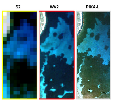
Space-borne hyperspectral imaging systems are devices with spectral coverage spanning from the visible to near-infrared (NIR) frequencies, occasionally also including ultraviolet (UV) and infrared frequencies (Marcello et al., 2020). It was outlined that there are several objectives for hyperspectral sensors, including observing the physiology of ecosystems, as well as the reflectivity, accumulation, and melting of snow and ice.
In this situation, a conceptual system that enhances snow management, resort navigation, and avalanche prediction through the use of a personal remote sensing system may be the solution. Remote sensing conceptual systems consist of multispectral, hyperspectral, and infrared satellites. Among the requirements for this solution is the Leica ADS80 camera, which is one of the leading devices for capturing geographical data and precise images (Pons et al., 2018). With its cutting-edge line-sensing technologies, Leica Geosystems can analyze and acquire data faster than any other camera.
As for the goals, it involves the training of employees on the use and analysis of the sensor. Such methods offer a valuable opportunity to demonstrate an understanding of the geographic variation in snow thickness on ski slopes (Transon et al., 2018). The objectives of this approach will be to evaluate the viability and prospects of using such distant location tools to enhance the knowledge ski resort management teams have about the spatial variability of snow complexity, which will aid in decision-making for tasks such as snowmaking, maintenance, and avalanche risk mitigation.
However, among the attributes that can be retrieved through multispectral and hyperspectral remote sensing are snow-covered regions, reflectivity, particle size, liquid extremely close to the surface, and temperature; however, there might be constraints. Among the challenges might be the detection of snow accumulation in forested areas and the adaptation of the techniques to frequent, large-scale computation. In this sense, extended employee training or recruitment of specialists might be required.
Literature Review
The difficulty of climate change for companies responsible for large sports facilities is positioned within a broader framework of advancements. According to Dingle and Stewart (2020), severe weather, rising sea levels, and flooding are among the consequences of global warming that may become intense, ubiquitous, and permanent if emissions of greenhouse gases continue at their current rate. However, Campos Rodrigues and colleagues (2018) emphasize that mountain ecosystems are considered more sensitive to climate change, which may have negative consequences, such as shorter snowfall seasons. Many studies focus on statistics, but it is also important to consider case studies.
Detailed examples may be the best indication of research progress in an area. Orr and Inoue (2019) established the connection between winter sports in the Olympics and the current climate crisis. They argue that precipitation was the most iconic weather-related picture of the 2010 Vancouver Olympics. This is a continuation of Inoue’s research, which significantly expands our understanding of the relationship between climate and sport. Reduced revenues, destroyed or damaged infrastructure, postponed or canceled competitions, and overall decreased participation in sports are all possible effects of climate change on sports organizations.
Skiing is one of the main winter sports influenced by environmental factors. The sport is primarily an outdoor practice, comparable to tourism. It depends on a temperate climate that provides suitable climatic conditions, such as temperature changes, precipitation, snow, frost, wetness, or winds, to produce the main sports product and activity (Dingle & Stewart, 2020). An example of this relationship between climate and sport is the dependence of skiing on colder climates.
Ski tourism is considered a billion-dollar industry. Approximately 350 million skiers travel worldwide yearly. Steiger et al. advanced their study in 2020 compared to 2019. They determined the magnitude of the decrease in overall demand resulting from weather conditions. If the deterioration is permanent, it will be 64%. If there are disruptions at the beginning and end of the ski season, the rate will be 18% (Steiger et al., 2020).
The lack of snow cover in ski areas was initially recognized as a significant threat to alpine resorts over 20 years ago (Bausch et al., 2019). Substantial limitations, including the lack of consideration of susceptibility, tolerance, or methods for adapting sports to global warming, were identified in the studies presented (Dingle & Stewart, 2020). The need for adaptation efforts is now evident as the lack of snow affects the skiing industry.
Research on climate change began to gain momentum about two decades ago. In 2000, Bodmer and colleagues (2000) emphasized the development of a management information system (MIS), which is built on a GIS-based professional framework that combines data from inventories, data, maps, satellite photos, and aerial photography. The use of UAVs proves effective in snow identification in the regions, as shown in the figure below.
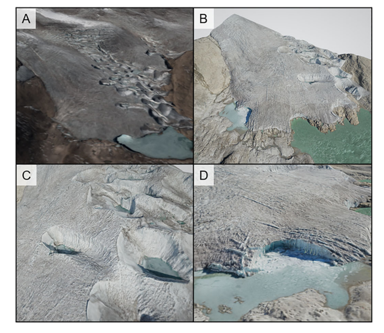
The sources that were older than 20 years proved to accentuate the similar issues of newer sources, which emphasizes the necessity of change. In warmer climates, remote sensing technologies are crucial for monitoring mountainous permafrost (Taylor et al., 2021). The development of new remote sensing systems with enhanced capabilities and image sensors can aid in preserving natural resources in natural environments, as illustrated in Figure 2 (Marcello et al., 2020).
For example, Snow Mappy enhances user experiences on the slopes for visitors to ski resorts by leveraging powerful geospatial technologies (Esri, n.d.). Thus, in terms of climate change, remote sensing systems are crucial for winter sports like skiing. The given sources, as can be seen, play a crucial role in ski resorts, as they draw attention to climate change and its detrimental effects.
Analysis and Findings
Hyperspectral remote sensing provides geophysical data and utilizes imagery to analyze current snow conditions on slopes in real-time. LIDAR data allows terrain identification with a spatial resolution of 1 m. In laser scanning, absolute errors of snow level did not exceed 0.6 m (Harder et al., 2020). Hyperspectral sensors enable the tracking of snow and ice accumulation and melting, and thereby facilitate the classification of ground cover in ski resort areas.
LIDAR satellites aid in assessing the spectral and spatial movements of objects, which are critical for monitoring systems such as snow cover (Kahraman & Bacher, 2021). The three-dimensional imaging capability enables the classification of object elevation information, a significant component of snow level monitoring, and is applicable in its analysis.
Cost, Materials, Technical, and Environmental Constraints
Hyperspectral imaging has a high cost associated with launching satellites, maintaining them, and transmitting information with subsequent analysis. Facilities require laboratories that can analyze and validate the images. The main technical requirement is the need for high-capacity memory systems and their protection, which ski resorts will not always be able to guarantee.
It also leads to a limitation in the need to create a system for evaluating good and poor-quality satellite images that can be applied to assess snow cover (Joiner et al., 2022). The environmental limitations of LIDAR satellites can be a consequence of the satellite launch itself, as combustible fuel is used and its oxidized products are released into the atmosphere, potentially affecting the climate.
Trades Made to Achieve the Selected Optimum
Multiple scattering using LIDAR technology enables a relatively accurate determination of snow depth. High resolution, one of the advantages, can make satellite operations difficult (Lu et al., 2022). However, compared to other methods, it is the most optimized and comfortable tool (Norton et al., 2022). Ski resorts need to transition to satellite systems and collaborate with space programs to remain competitive. The ability to navigate and respond quickly to change will ultimately offset the cost of LIDAR materials and technology.
Final System Performance Effectiveness Evaluation
Implementing remote sensing technology has advantages over other technologies. It is justified primarily by the ability to continuously track the condition of the snow cover. In addition, the ability to measure the height of the cover rather than analyze its particles is the advantage of LIDAR satellites. The weaknesses include difficulty in predicting errors and distinguishing which images are false and which are true (Fair, 2021). Mullen et al. (2022) argue that UAVs could be used instead of satellites because they can cover bigger areas and minimize harm. Currently, no fully automated systems support such satellites and therefore analyze them.
Lessons Learned
LIDAR systems can be valuable tools in organizing geophysical assessments of snow conditions, which play a crucial role in winter sports and recreation. Li et al. (2022) emphasize that the capabilities of these systems are essential for a comprehensive study of the cryosphere and, consequently, for informed decision-making in climate conservation and management. Earth climate monitoring programs are a source of forecasting the overall path of ecology and allow for a new perspective on any snow-related activities. The best way is to integrate hyperspectral satellite technology into winter sports management processes.
Synthesis and Interpretation
Climate change is one of the critical challenges for ski sports, as the recorded gradual decrease in snow cover thickness poses difficulties in hosting the Olympic Games. Skiing is highly dependent on snow conditions, and Orr & Inoue (2019) note that climate change effects could severely impact the games. Guzman (2022) points out that the Olympic Committee is concerned about the technology used at the Beijing games. The efficiency of artificial snow is not high, as the presence of waste and energy costs compromises its environmental friendliness. Consequently, the current natural snow climate is an advantage that cannot be guaranteed in the face of ongoing warming and melting of snow and ice on mountain slopes.
Conclusion
The purpose of this research was to examine and understand the impact of climate change on skiing and to determine the most effective methods for monitoring snow thickness during winter, to reduce costs. In particular, the motivation for conducting the study stemmed from the realization that skiing is becoming a challenging and expensive activity due to the continuous reduction of winter days with sufficient snow for skiing, primarily attributed to global warming and climate change.
To combat the reduced business, companies in this sector are forced to relocate their customers to higher altitudes where the surface has adequate snow for skiing, which is quite expensive. In turn, they pass these costs to their customers, thus making the activity less attractive to visitors. However, some technologies and applications can help companies in the industry reduce costs by monitoring the snow occurrence on the surface during winter and determining the best way to hold skiing events.
This study examines how the LINDAR system operates to achieve this objective. The results indicate that the approach is highly effective, as it has the capacity to capture high-resolution 3D images of the surface, allowing analysts to determine the thickness and geographical extent of the snow. Precisely, skiing depends on the thickness or height of the snow on the earth’s surface. A reduction in this metric is a factor that affects winter activities.
With an understanding of the precise volume and height of snow in a given region, skiing companies can determine the best locations for winter activities rather than making costly assumptions. However, the study also finds that the LINDAR approach has some weaknesses. Specifically, it is challenging to predict errors and distinguish between false and true images.
Recommendations
Global warming and climate change pose a real threat to the skiing industry, due to reduced snow cover and the number of winter days available to support the activity. It is expected that the phenomenon will persist for the next few decades unless adequate measures to combat climate change are implemented. Currently, few measures are in place, and carbon emissions are increasing daily. Consequently, the skiing business is expected to face challenges as the number of winter days continues to decline and the thickness of snow on the surface decreases.
Therefore, this research provides important recommendations for ski companies to apply and reduce the cost of their business. First, it is recommended that companies use technologies to monitor snow occurrences at various locations during winter. Remote sensing tools are the most applicable approaches in this case. The LINDAR system has proved to be the most effective remote sensing tool due to its capacity to provide data and 3D images of snow on the surface without the need for traveling to obtain data. With this system, companies can accurately measure and determine the thickness or height of snow on the surface and its geographical spread.
Secondly, the LINDAR tool is relatively cost-effective, as it utilizes satellite technology readily supplied by other companies at a fee. With accurate data on the thickness and geographical distribution of snow in different areas, companies can determine the optimal locations for winter sports. In this way, it is possible to reduce costs and the fees charged on visitors. However, LINDAR has weaknesses, and it is suggested that UAVs should replace satellites because they can cover large areas and minimize harm. It also suggested that analysts utilize fully automated systems to support such satellites and enhance their ability to analyze the data.
References
A new way to navigate the slopes: With real-time geospatial data: ArcNews: Winter 2022. Esri. (2022). Web.
Esri. (n.d.). Entrepreneur’s dream ski app empowered by GIS and location intelligence. Esri. Web.
United Nations. (n.d.). What is climate change? United Nations. Web.
Bausch, T., Humpe, A., & Gössling, S. (2019). Does climate change influence guest loyalty at alpine winter destinations? Sustainability, 11(15), 1-32. Web.
Bodmer, H. C., Seidel, K., & Aerts, J. (2000). Remote sensing-based management information system for ski resort planning. In M.F. Buchroithner (Ed.). A decade of trans-European remote sensing cooperation, pp.319-325.
Bühler, Y., Bebi, P., Christen, M., Margreth, S., Stoffel, L., Stoffel, A., Marty, C., Schmucki, G., Caviezel, A., Kühne, R., Wohlwend, S., & Bartelt, P. (2022). Automated avalanche hazard indication mapping on a statewide scale. Natural Hazards and Earth System Sciences, 22(6), 1825-1843. Web.
Dahlman, R. L. A. N. D. L. A. (n.d.). Climate change: Global temperature. NOAA Climate.gov. Web.
Dingle, G. W., & Stewart, B. (2020). Playing the climate game: Climate change impacts, resilience, and adaptation in the climate-dependent sport sector. In Creating and managing a sustainable sporting future (pp. 39-59). Routledge.
Guzman, C. d. (2022). What artificial snow at the 2022 Olympics means for the future of winter games. Time. Web.
Harder, P., Pomeroy, J. W., & Helgason, W. D. (2020). Improving sub-canopy snow depth mapping with unmanned aerial vehicles: Lidar versus structure-from-motion techniques. The Cryosphere, 14(6), 1919-1935. Web.
Joiner, J., Fasnacht, Z., Qin, W., Yoshida, Y., Vasilkov, A. P., Li, C.,… & Krotkov, N. (2022). Use of hyper-spectral visible and near-infrared satellite data for timely estimates of the Earth’s surface reflectance in cloudy and aerosol-loaded conditions: Part 1–application to RGB image restoration over land with GOME-2. Frontiers in Remote Sensing, 2, 1-10. Web.
Kahraman, S., & Bacher, R. (2021). A comprehensive review of hyperspectral data fusion with lidar and SAR data. Annual Reviews in Control, 51, 236-253. Web.
Lu, X., Hu, Y., Zeng, X., Stamnes, S. A., Neuman, T. A., Kurtz, N. T., Yang, Y., Zhai, P.W., Gao, M., Sun, W., Xu, K., Liu, Z., Omar, A. H., Baize, R. R., Rogers, L. J., Mitchell, B. O., Stamnes, K., Huang, Y., Chen, N., … Fair, Z. (2022). Deriving snow depth from ICESat-2 Lidar multiple scattering measurements: Uncertainty analyses. Frontiers in Remote Sensing. Web.
Marcello, J., Eugenio, F., Gonzalo-Martin, C., Rodriguez-Esparragon, D., & Marques, F. (2020). Advanced processing of multiplatform remote sensing imagery for the monitoring of coastal and mountain ecosystems. IEEE Access, 9, 6536-6549. Web.
Mullen, A., Sproles, E. A., Hendrikx, J., Shaw, J. A., & Gatebe, C. K. (2022). An operational methodology for validating satellite-based snow albedo measurements using a UAV. Frontiers in Remote Sensing. Web.
Norton, C.L., Hartfield, K., Collins, C.D.H., van Leeuwen, W.J.D., & Metz, L.J. (2022). Multi-temporal LiDAR and hyperspectral data fusion for classification of semi-arid woody cover species. Remote Sensing, 14(2896). Web.
Orr, M., & Inoue, Y. (2019). Sport versus climate: Introducing the climate vulnerability of sport organizations framework. Sport Management Review, 22(4), 452-463. Web.
Pons, M., Lopez, J.I., Revuelto, J., Alonso, E., Vilella, M., Travesset, Apodaka, J., Pesado, C., Margalef, A., & Iravani, P. (2018). Remote sensing techniques for helping decision-making in the management of ski areas. International Snow Science Workshop Proceedings. Web.
Steiger, R., Scott, D., Abegg, B., Pons, M., & Aall, C. (2019). A critical review of climate change risk for ski tourism. Current Issues in Tourism, 22(11), 1343-1379. Web.
Steiger, R., Posch, E., Tappeiner, G., & Walde, J. (2020). The impact of climate change on demand for ski tourism: a simulation study based on stated preferences. Ecological Economics, 170, 106589. Web.
Scott, D., Hall, C. M., & Gössling, S. (2019). Global tourism vulnerability to climate change. Annals of Tourism Research, 77, 49-61. Web.
Taylor, L. S., Quincey, D. J., Smith, M. W., Baumhoer, C. A., McMillan, M., & Mansell, D. T. (2021). Remote sensing of the mountain cryosphere: Current capabilities and future opportunities for research. Progress in Physical Geography: Earth and Environment, 45(6), 931-964. Web.
Fair, Z. (2021). Application of lidar altimetry and hyperspectral imaging to ice sheet and snow monitoring. Dissertation. The University of Michigan. Web.
Transon, J., d’Andrimont, R., Maugnard, A., & Defourny, P. (2018). Survey of hyperspectral earth observation applications from space in the Sentinel-2 context. Remote Sensing, 10(2), 1-32. Web.