Abstract
Navigation has evolved over the years from rudimentary forms that included the use of celestial bodies to the satellite-assisted systems used today. Over the years with each new system solving the preceding systems errors aircraft navigation has improved at a constant pace. These improvements have made air travel safer and today these systems have greatly eased the work on all staff whether in flight or on the ground. Global Positioning Systems have brought many advantages to the airline industry and justify their inclusion as an essential tool in commercial navigation systems around the world.
History of GPS
History reports rudimentary navigation techniques included the use of celestial bodies to support maritime and air transportation. For example, long before recorded history, Chinese narratives indicate reports of soldiers using a compass for navigation in foggy weather (Tsui, 2005). However, this report is concerned with the details of more sophisticated navigation mechanisms used in several industries today with a significant impact on operations. As the name suggests Global Positioning Systems (GPS) is a navigation tool that is used to provide data on the relative position of objects.
These GPS systems which can be traced to the military are the topic of discussion in this paper and are based on the use of satellite technology. These systems were initially designed by the US Department of Defense starting in the early 1960s (Broida, 2003). The Department required a global positioning and navigation system that could provide continuous highly reliable data that was not prone to adverse weather. The primary goal of these experimental satellite systems was to help weapons hit targets with greater precision.
As a result of these efforts the Navy was first to develop a system called Transit, consisting of seven satellites at low altitudes and several ground stations. The system was made available to civilian users in 1967 with only rudimentary two-dimensional positioning capabilities (Broida, 2003). This paved the way for further work on such systems having proven that space-based surveillance could be reliably used for navigation purposes. Following these successful attempts the GPS program was approved in 1973 and in 1978 the first satellite was launched. By 1993, the GPS program had 24 satellites in orbit and initial operational capability was established. In 1994, the GPS program was declared ready for aviation use by the Federal Aviation Agency (FAA) (Tsui, 2005).
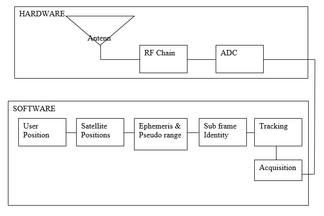
The Basic GPS Receiver
For a better understanding of basic GPS operations receiver refer to the diagram (Figure I) (Tsui, 2005). The antenna of the receiver collects signals that are transmitted by satellites. This information received can be used for navigation of the object to which the receiver is attached. The data itself will usually include latitude, longitude, speed, heading and time (Broida, 2003).
The data itself is transmitted in the form of radio waves and hence the Radio Frequency (RF) chain component. This device will amplify the input signal to the correct amplitude as well as convert the frequency of the output signal to the correct frequency. The data is then passed on to the Analog to Digital Converter (ADC) whose purpose is to convert the input signal to a digital format and analog conversion for an output signal (Tsui, 2005). These two components are the hardware within the receiving system.
After these components have transformed the signal software is used to process it further. Acquisition refers t the process of identifying the signal of a particular satellite. The tracking software is used in the identification of changes in the state of the navigation data. Having collected the navigation data changes, subframes and data for navigation can be measured. Ephemeris and pseudo-range can be calculated from this data. The ephemeris data is used to locate the satellite position. Finally, the user position can be calculated depending on the satellite position and estimated reported range (Tsui, 2005).
GPS works based on a process called triangulation. In this procedure, the determination of the location of a position is reached using distances as opposed to angles. The GPS receiver calculates the distance from a given satellite using calculations based on time taken to receive a signal from the satellite. In addition to this it also records information on the orbit of the satellites in the internal memory. With the precise location of any three satellites, the GPS receiver can easily perform calculations to identify its position (Hinch, 2007).
Even though this is the basic mode of operation for most GPS receivers, it should not be assumed that one receiver can be used for all navigation requirements. For example, a GPS device that may be used by a driver of a truck delivering parcels will not be the same as a GPS device used by a mountain climber (Broida, 2003). This is because though the devices send out similar signals, the format used to present the results will vary based on the expected purpose of the device. The device designed for driving within cities and highways may represent the results using a map of roads within the locality stored on the satellite. This representation of data is most likely inappropriate for the mountain climber.
Reasons for Change to GPS in Airline Industry
Traditional surveillance and communication devices in the commercial airline and maritime industry often utilized the HF radio for communication. This mode of communication is also used for ship to ship, ship to shore, air to ground and ground to air communication (Moldwin, 2008). The radio frequencies for HF radio are typically between 3 and 30 MHz and the band is also popular among amateur radio stations.
This mode of communication relies on the bouncing of radio waves off the ionosphere and was the basis of the first Trans Atlantic radio communication in 1901. However, the ionosphere is variable and communication ability can vary based on factors such as weather, amount of solar activity and geomagnetic activity. It is reported that degradation of the ionosphere often causes communication breakdown in Transpolar flights. As a result of these several commercial airlines are switching to the use of satellite phones and using HF radio as a backup system (Moldwin, 2008).
The move to modernize was a result of several factors, including politics and air disasters. An example of a widely reported air disaster occurred in 1956 over the Grand Canyon and was a result of the collision of two aircraft. There was no nationwide radar system at the time and controllers would track planes using markers on paper or a map. This accident prompted the US government to enforce a regulation that required the mandatory use of radar in tracking all US planes (Rauf & Vescia, 2008). However, the HF radio used for radar communication was not without its own inherent problems such as poor availability in bad weather.
Despite the difficulty associated with HF radio, the availability of GPS receivers for civilian use was not a key priority among military personnel who were constantly conscious of how these devices could be used by enemies. This position changed following the shooting down of a Korean flight 007 by the Soviet Union. The fight crew of the ill-fated 747 had made a navigation error that saw the flight surface on Soviet radar.
During this error the Soviet Union was very xenophobic given that the cold war was still very much alive. Without making further efforts to investigate the Russians shot the lane down committing a fatal mistake. Following the tragedy, the then US President Ronald Regan announced that GPS signals were to be made available to the entire world at no charge (Hinch, 2007). Since this announcement, the use of GPS in civilian and commercial enterprises flourished.
GPS in Airline Industry
This point was highlighted by the US Federal Aviation Administration in 1998, in a statement that described satellites as more precise and safer than ground-based radio stations (Polishuk, 1998). This report was published after a four-month testing period on routes between Miami, Fl and the Caribbean that saw the GPS perform so well that FAA was considering making it standard procedure for all commercial travel across the US. In support of GPS, the FAA reported that GPS was saving the passengers time, about five minutes on a typical flight between Miami and Puerto Rico. Further The FAA indicated that it also saved the airlines money which over the course of a year translated into millions in fuel costs.
This is possible based on the fact that GPS allows the airline to fly the most direct route possible to its destination. In addition to that the use of GPS is likely to allow air traffic control systems to manage more aircraft by increasing the number of routes from 2 to almost 20 (Polishuk, 1998). The aircraft without GPS systems are forced to maintain two routes to fly over radio fixes along the path to the destination. This system is very beneficial during high altitudes en route to a destination.
However, upon approaching a landing field aircraft must still home to ground stations to land safely. Air traffic controllers in-ground stations also agree that GPS provides for better separation of aircraft allowing them to handle more aircraft. In addition to this it is reported that aircraft using GPS do not drift from route whereas 5 % of those relying on normal navigation drifted from their routes (Polishuk, 1998).
Following such successful attempts at the integration of GPS in commercial aviation trends such as required navigation performance or RNP are now widely in use to determine whether or not a commercial airliner is clear to take to the skies. These standards came into being owing to the potential to anticipate the improved time and fuel savings, improved on-time performance, and greater operational flexibility through the use of these new operational parameters (Gordon-Smith, 2003). However, as it would be expected the new regulations pose a challenge for owners of older aircraft who are forced to assess the costs of upgrades. Some practitioners within the aviation industry have even suggested that RNP is the key to future communications, navigation and surveillance and air traffic management (CNS/ATM) (Gordon-Smith, 2003).
The RNP concept has been reported as capable of providing navigational accuracy that could not even be dreamed of in civil aviation as recently as 20 years ago. The Global Satellite Navigation Systems (GNSS) rely on information provided by almost 24 operational satellites orbiting the earth (Rauf & Vescia, 2008). Through the data provided by GNSS the required navigation performance of an aircraft can be assessed.
The reasons for this lie in the fact that the combination today that brings together satellite navigation, inertial reference systems, ground-based navigation aids coupled with powerful onboard flight management computers and advanced automated flight control have seriously increased the navigation capacity of aircraft and the industry (Gordon-Smith, 2003). Through this technique large blocks of airspace that separate aircraft can safely be reduced thus allowing a larger amount of air traffic thereby increasing capacity while ensuring safety standards are maintained.
The RNP navigation protocol stipulates that aircraft navigation ability is no longer stipulated by onboard equipment but rather by the ability to conform to required navigation performance. It is hoped that eventually RNP will allow the airways to evolve into narrow tightly defined airspace “tubes” along which all air traffic will flow (Gordon-Smith, 2003). Although data available is yet to show that route spacing can be reduced below 7 NM, the main concern is not navigation accuracy but the errors that could be introduced by human error (Gordon-Smith, 2003).
The implementation of increasingly accurate degrees of RNP implies that aircraft will travel over very consistent, accurate and repeatable paths over the ground along any given route. In addition to easier air traffic control, the airspace planner will also have an easier time of mapping paths for arrival and departure, allowing them to thread their way around noise-sensitive urban areas.
With these increased performance benefits in 2002, the FAA announced its intention to introduce a five-year RNP RNAV program (Gordon-Smith, 2003). Already it has granted approval for use of this RNP RNAV protocol on a number of domestic routes to certain air carriers. The RNAV technology has been reported to be effective in providing access to otherwise inaccessible airports as well as significant capacity benefits in less demanding environments. Even though RNP RNAV is still not recognized by the International Civil Aviation Organization (ICAO) and minimal functional requirements are still under review, it has been established that RNP RNAV will bring significant benefits t the industry including time and fuel savings, improvements in schedule adherence and operational flexibility (Gordon-Smith, 2003).
Capabilities of GPS
In approving the use of RNP for navigation the ICAO provided a set of parameters that the new technology should meet to ensure safety standards are maintained across the industry. These parameters are briefly explained in this section to highlight the capabilities of RNP. The parameters required that the systems maintain a degree of accuracy of 95% (Ochieng et al., 2003). Accuracy is defined as the degree of conformance of a position estimate at a given time to a defined reference value. This suggests that the data provided by the system is very accurate.
Another major advantage of the RNP concept is that the system is not prone to interruptions and as such can guarantee safety (Ochieng et al., 2003). It has been stated earlier that one major failure of the HF radio was unavailability owing to adverse weather. This ability to have the system online throughout the intended period of operation is essential to ensure reliability.
In ensuring the replacement was worth the effort the ICAO also runs tests to ensure the system maintains a high level of data integrity. Integrity refers to the degree to which the information provided by the system can be trusted. Among the integrity measures included is an ability to provide timely warnings when the system is unavailable. The system is expected to provide an alert in the event of a malfunction (Ochieng et al., 2003). Among the integrity checks included in the system include alerts that can indicate that accuracy has degraded or alerts that indicate accuracy has degraded below safety levels.
Impact on Airline Industry
The transportation industry in the US is a key component of the economy. For example, reports indicate that air travel accounts for 42% of the total passenger trips covering a round trip distance of between 1000-1999 miles (Duke &Torres, 2005). These reports also indicate air travel accounts for 75% of travel over round trip distances is greater than 2000 miles. Given that improvements in navigation have reported significant savings in time for passengers and fuels costs for airlines, this implies that if these improvements are sustained this sector is bound to increase its income. It is possible to assume that reduced fuel costs will reduce the cost of flying.
Also the improvements in air traffic control will lower administrative costs for airlines which are likely to be transferred to the passenger as well. This is not because the use of more direct routes and increased capacity in the airspace suggests increased numbers using air travel (Gordon-Smith, 2003).
In a report on the economic contribution of the airline industry, it has been stated that labor productivity is often used in the measurement of economic performance. Labor productivity is widely used by analysts in monitoring the state of health of an economy. When productivity is high the competitiveness of an industry or nation is also high in relation to this. Whereas labor productivity measures the change in output related to a single input, multifactor productivity measures change in output as a result of several inputs. The changes in terms of growth in the airline industry can be attributed to several factors such as federal legislation, competition (Duke & Torres, 2005).
This point is important because the legislation that brought about the use of RNP is among the factors responsible for this growth. As such it is possible to suggest that the new legislation has resulted in increased economic productivity of the airline industry. This point is reiterated by the study that indicates the introduction of new technology and its potential to improve the handling of air traffic. It is suggested that these improvements are likely to increase profitability within the airline industry.
Among the most apparent advantages that have come about owing to the use of GPS for flight navigation is the ability to plan and fly a plane with minimal radio assistance (Dixon & Harris, 2004). Due to this technology, it is possible to fly over short distances with almost as little planning as is required to take a car for a drive on a rainy day. This is possible due to the capabilities of modern GPS devices that would require an experienced pilot to carry only information on the trip on paper to feed into the device. This information is readily available through FAA software known as Direct User Access Terminal System (DUATS). The DUATS system is available free of charge via two computer-based weather briefing and flight planning services namely; CSC DUATS and DTC DUAT (Dixon & Harris, 2004).
The DUATS flight planner can save users valuable time and effort by automatically performing essential calculations for them. The system can be accessed by pilots with valid medical records and a few others in categories that lack the requirement for medicals. The system requires a user to enter departure time, cruising altitude, aircraft information and routing preference (selecting Direct Routing provides a GPS great circle routing).
The system provides a complete flight log that includes distances, times, headings, and fuel burns based on the winds at the altitude selected (Dixon & Harris, 2004). Unfortunately, the option of Direct Routing is not applicable for pilots without specialized equipment. In addition to the information in the log the flight planner provides backup VHF omnidirectional radio (VOR) stations as required by FAA. This system based on the benefits and concepts of GPS is extremely essential and useful for pilots in remote regions.
The shift to the use of GPS technology in the airline industry arose as a result of the failure of air traffic control to manage demands for increased air space capacity. As a result of this, the ICAO made recommendations for research into new technologies that could be used for future aviation navigation requirements (Ochieng et al., 2003). Following increased demands on the GNSS system, a new program known as GPS III is set to launch its first satellite into orbit in 2009. It is expected that GPS III will reach full operational capacity around the year 2020 (Ochieng et al., 2003).
Conclusion
In this paper, the discussion presented provided information on GPS and its role in the airline industry. In the beginning it is reported that navigation was mainly performed using radio communication that is prone to adverse weather and other conditions. Owing to this the military embarked on development of systems that could be used to provide a greater degree of accuracy and reliability.
It was not long before these solutions also became essential in civilian activities such as the commercial airline industry. After political directives identified the need to allow airlines to integrate these technologies into their operations, the use of GPS has been used in the industry to a high degree. The technology has brought with it major benefits to the industry and it is suggested the future of the industry could be dictated by its ability to comply with the demands of the technology.
References
Broida, R. (2003). How to Do Everything with Your GPS. New York: McGraw-Hill/Osborne.
Dixon, P. & Harris, S. (2004). Mastering GPS Flying. New York: McGraw-Hill Professional.
Duke, J. & Torres, V. (2005). Multifactor productivity change in the air transportation industry. Monthly Labor Review, 32, pp. 32-46.
Gordon-Smith, M. (2003). RNP Promises Significant Economic Benefits to the Airline Industry. ICAO Journal, 3, pp.
Hinch, S. W. (2007). Outdoor Navigation with GPS. Berkeley: Wilderness Press.
Moldwin, M. (2008). An Introduction to Space Weather. Cambridge: Cambridge University Press.
Ochieng, W. Y., Sauer, K., Walsh, D., Brodin, G., Griffin, S. &Denney, M. (2003). GPS Integrity and Potential Safety on Aviation Safety. The Journal of Navigation. 56, pp. 51-65.
Polishuk, P. (1998). FAA Considers using Satellite Navigation Nationwide. Fiber Optics Weekly Update, pp. 4-5.
Rauf, D. & Vescia, M. (2008). Airline Pilot. New York: Infobase Publishing.
Tsui, J. B. (2005). Fundamentals of Global Positioning System Receivers: A Software Approach. New Jersey: John Wiley & Sons Inc.
Appendix