Wegener’s hypothesis, known as the theory of continental drift, was based on a wide range of data from geological expeditions worldwide. He was intrigued by the division of the American continents and worked to explain their non-standard shape. In addition, Wegener studied animal and plant fossils on the coastlines of Africa and South America. This work is well-deserved, and the researcher’s arguments are convincing that a number of organisms he found could not overcome a large area of the Atlantic Ocean on their own, which indicated a common geological basis. The climatic changes mentioned by Wegener were also viewed as a consequence of continental drift.
Although Wegener’s theory was reasonable and suggested a number of rationales, some gaps prevented it from gaining widespread acceptance during the researcher’s life. The main problem was the lack of a rationale for how exactly Pangea split into several continents. In addition, Wegener could not unequivocally answer the question of what force made the continents overcome such great distances and form the picture of the world that corresponded to contemporary maps.
In the decades that followed Wegener’s death, his theory of continental drift was refined, which made it possible to formulate the Plate Tectonic theory. Its key points included the facts supporting the researcher’s original arguments about the movement of the continents. After studying the ocean floor, its strength and youth were proven. According to the data obtained, the inversions of the planet’s magnetic field were proven to have happened more than once in the past. The seabed was presented as a surface prone to spreading, which, in turn, led to the recirculation of the oceanic crust. Finally, it was reliably proven that volcanic activity and earthquakes were concentrated in the regions of oceanic trenches and mountain ranges, which was also an important discovery.
Each map reflects the activities of tectonic plates, which manifest themselves on the surface of the earth. The seismological map shows the areas of earthquakes that occur at the joints of the plates and are most powerful in the places of breaks. The volcanic map demonstrates the same areas, and judging by the activity of the volcanoes, they are located in places of plate boundaries. The seafloor age map emphasizes the young nature of plate regions in continental areas, which indicates their later shifts compared to the seafloor in the centers of the breaks. The topographic map reflects the levels of heights on the surface of the earth, which are higher in the places where plates’ boundaries pass.
The proposed maps can be used to determine the direction of plate movement. Each one represents a reflection of where the boundaries go, and by expanding those areas, one can determine where the plates are moving. By comparing early maps with recent ones, one can also match the position of the plates and find the real movement algorithm, which is seen particularly well on the seafloor age map.
Three types of boundaries can be distinguished by analyzing the movement of tectonic plates. One of them is the diverging boundary when plates break and create volcanic activities and earthquakes. Another type is a converging boundary when earthquakes and volcanic activities are significant and occur frequently. Finally, transform boundaries are those places of minor collisions, where volcanic activities and earthquakes are insignificant and not frequent.
For the diverging type of boundaries, high grounds are uncharacteristic, and the geologic activity is stable, including volcanoes and earthquakes, but not strong. At the converging boundaries of plates, mountain ranges are formed, and frequent volcanic eruptions and severe earthquakes occur periodically. At transform boundaries, uplands are not high, and although volcanic activity and earthquakes occur, they are not as severe as at converging boundaries.
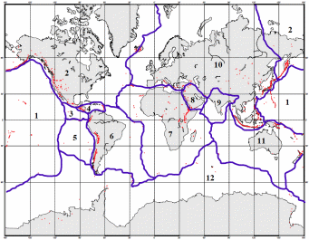
In Figure 1, plate boundaries are demonstrated, and their location indicates high volcano activities. The following plates have been included: Pacific Plate (1), North American Plate (2), Cocos Plate (3), Caribbean Plate (4), Nazca Plate (5), South American Plate (6), African Plate (7), Arabian Plate (8), Indian Plate (9), Eurasian Plate (10), Australian Plate (11), and Antarctic Plate (12). None of the plates have been missed, which is largely due to the aforementioned maps. The seismological and volcanic maps have contributed to identifying plate breaks. The seafloor age map has helped determine the center lines of joints. The topographic map has shown the places of the highest uplands and, therefore, plate boundaries.
As a result of this lab, I have gained a broad understanding of the Plate Tectonic theory and the principles of terrain formation on the earth. In addition, I have learned what geologic activity depends on and how plate movement and boundaries are associated with volcanoes, earthquakes, and local climates. The most intriguing aspect concerns the fact that for centuries, people were unaware of the movement of tectonic plates. Only due to Wegener and his research, discoveries in this area began to be carried out, and humanity learned about Pangea and the changed shape of the earth. The history of the Plate Tectonic theory has shown me that the process of scientific inquiry requires collecting objective data to provide sufficient evidence to support proposed hypotheses and concepts.