Introduction
Even though modern aircraft have sophisticated navigation and communications systems helping to ensure the safety of flight, they are still wholly dependent on the atmosphere, which generates aerodynamic forces sustaining them. Also, all avionics systems for navigation and communications rely on signals that have to penetrate the atmosphere before reaching the flight deck (Frey, 2015). The same can be said about signals connecting the flight deck with the ground. Therefore, aviation safety depends on the state of the atmosphere. This paper aims to explore aviation-significant atmospheric phenomena of clouds and wind.
Clouds
Clouds are the visible manifestation of certain weather conditions and are often referred to as “signposts in the sky” (FAA, n.d., p. 53). According to Wikson (2014), clouds are formations of either water droplets or ice crystals or both. Average clouds last only 15 to 20 minutes, whereas Cumulonimbus and thunderstorms can exist for several hours (Wikson, 2014).
Types of Clouds
The simplest methods of cloud classification are by their height bands and by the stability of conditions under which they are formed. By using these methods of classification, it is possible to divide all clouds into two groups: layer clouds and heap clouds. Clouds produced by vertical currents under unstable air conditions are referred to as cumulus. Clouds produced by “the cooling of a stable layer” (FAA, n.d., p. 53) are called stratus.
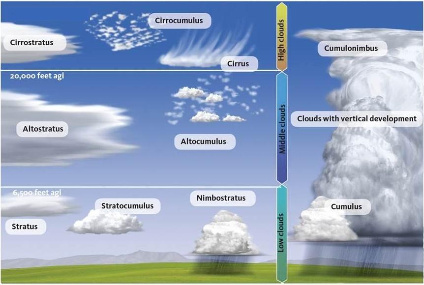
To classify rainclouds, meteorologists, and pilots using Howard’s system of cloud naming use the prefix number and the suffix nimbus (Williams, 2016). Therefore, clouds producing rain are called nimbostratus, and clouds producing precipitation are referred to as cumulonimbus (Williams, 2016). To name clouds that are broken into small formations, aviation meteorologists use the suffix fractus, thus fragmentary cumulus is referred to as cumulus fractus (FAA, n.d). Figure 1 shows the different types and levels of clouds.
Levels of Clouds
For identification purposes, pilots discern the following levels of clouds: “high clouds, middle clouds, low clouds, and clouds with extensive vertical development” (FAA, n.d., p. 53). It should be mentioned that it is the height of a cloud’s base that determines its classification (Wikson, 2014).
High clouds belong to the cirriform group and include the following types of clouds: cirrocumulus, cirrostratus, and cirrus (FAA, n.d.). The clouds of this level are primarily composed of ice and are characterized by their thin and white appearance. High-level clouds are formed above 20, 000 feet AGL (Williams, 2016). According to Williams (2016), these clouds can provide pilots with clues about the weather in the next several days.
The group of middle clouds includes altostratus, altocumulus, and nimbostratus (FAA, n.d.). These clouds are formed between 6, 500, and 20, 000 feet AGL (Williams, 2016). The prefix alto indicates their height. The appearance of middle clouds suggests that “lower clouds and precipitation are on the way” (Williams, 2016, para. 7).
The following clouds compose the group of low clouds: stratus, stratocumulus, and cumulus (FAA, n.d.). The height of the bases of low clouds ranges from the surface to 6, 500 feet AGL (FAA, n.d.).
Towering cumulus and cumulonimbus are vertically developed clouds that consist almost entirely of supercooled water. However, when these clouds reach substantial heights, their water transforms into ice crystals. The height of bases of clouds with extensive vertical development ranges from 1, 000 to more than 10, 000 feet AGL (FAA, n.d.).
Dew, Fog, Mist, Humidity and Dew Point
Dew can be defined as the water droplets that are formed through the process of “condensation of water vapor on a relatively cold surface of an object” (UMBC, n.d., para. 1). The formation of dew is only possible when the temperature of a surface is below the dew point, which is a measure of humidity (Wikson, 2014). The dew point temperature refers to “the temperature to which moist air is cooled at constant pressure and at constant water vapor to reach saturation concerning water” (UMBC, n.d., para. 2).
Fog can be defined as tiny water droplets suspended in the air near the Earth’s surface, which reduces the visibility to 6.2 miles or less (UMBC, n.d., para. 9). However, if the visibility exceeds that limit, water droplets are referred to as mist. Humidity is a term that is used to describe the amount of water suspension in the air (Wikson, 2014).
Effects of Clouds, Fog and Mist on Flying
By understanding cloud types, pilots can substantially enhance their aviation knowledge, thereby increasing the safety of their flights. Basic knowledge of cloud types can spell the difference between a safe flight and a dangerous one (Wikson, 2014). While solid clouds are associated with frontal movement, broken ones are associated with turbulence (Wikson, 2014). It is also necessary to understand the process of cloud formation because it can help to recognize cumulonimbus or thunderstorms that are exceptionally hazardous to flying.
Fog and mist can substantially impact visibility; therefore, pilots have to understand mechanisms and conditions associated with fog formation. Also, they should discern different types of fog that include radiation fog, advection fog, upslope fog, frontal fog, and freezing fog (Wikson, 2014).
Precipitation
Precipitation is associated with processes such as condensation, which occurs at 100 percent relative humidity, and coalescence (Experimental Aircraft Info, n.d.). Deposition can be defined as “the process of water vapor molecules condensing on ice crystals” (Experimental Aircraft Info, n.d., para. 4). Coalescence is the process during which water droplets fuse. There are many forms of precipitation, and they all depend on the air temperature and its stability. The basic types of precipitation are drizzle, rain, snow, and hail.
Thunderstorms
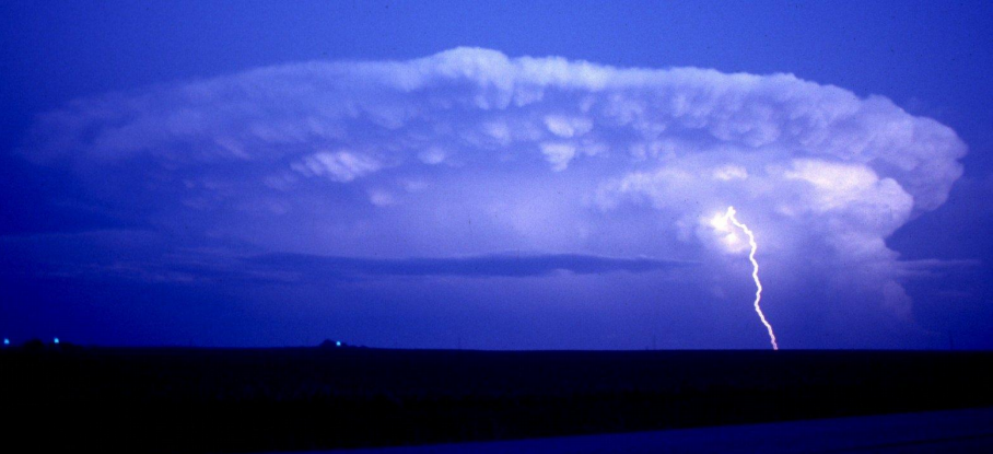
Knowledge of thunderstorms is critical for aviation; therefore, pilots have to understand a thunderstorm lifecycle, its types, and related hazards to prevent accidents. (FAA, 2013). Whether referred to as a thunderstorm has the following stages: the cumulus, the mature, and the dissipation (FAA, 2013). There are four types of thunderstorms: single-cell, cluster, squall line, and supercell (FAA, 2013). All thunderstorms are hazardous to aviation. Figure 2 shows a thunderstorm.
Wind
Causes
The wind is a complex system of air movement that is set in motion by differences in pressure (Frey, 2015). Air is driven by the pressure gradient force that causes it to move from regions of high pressure to low pressure to attain equilibrium. This movement is perpendicular to isobars and intensifies with its proximity to them. When there is a difference in temperature between two surfaces, the warmer air expands, whereas the cooler air becomes denser and gets pulled to the Earth’s surface by gravitational force. Figure 3 shows the convection current.
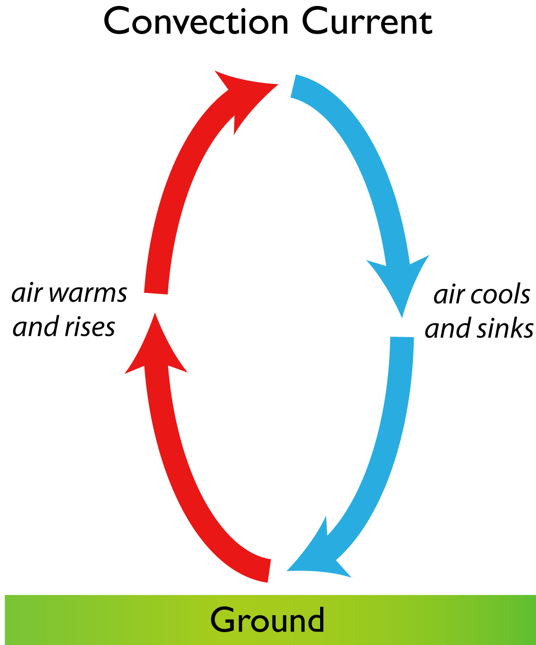
The warmer air that rises upwards eventually cools and descends to the ground, thereby closing the cycle of the convective circulation. However, as long as there is uneven heating, convection continues and gives rise to the horizontal movement of air, which is referred to as wind. The process of convection at different scales creates both hemispheric circulations and small eddies (Frey, 2015).
Coriolis Force
A mass of air driven by pressure gradient force would move in a straight line if it were not for a force discovered by Gustave-Gaspard Coriolis in 1835 (Encyclopaedia Britannica, n.d.). The scientist showed that “an inertial force that acts to the right of the direction of body motion for counterclockwise rotation of the reference frame” (Encyclopaedia Britannica, n.d., para. 1) has to be a part of the motion equation within a rotating frame of reference. It means that Coriolis force “deflects air to the right in the Northern Hemisphere and to the left in the Southern Hemisphere” (Encyclopaedia Britannica, n.d.a, para. 2).
It should be mentioned that the force is always at a right angle to the movement of the wind. Also, there is a direct connection between the Coriolis force and wind speed. The effects of the force are more pronounced at the poles and virtually non-existent at the Equator (Frey, 2015). The force influences not only air currents but also deflects movement of birds, ocean currents, and aircraft among others.
Gust and Lull
A wind gust can be defined as a sudden burst of wind (Encyclopaedia Britannica, n.d.b, para. 2). Wind gusts are followed by a marked decrease in the wind intensity and speed that is referred to as lull. In meteorology, gusts are reported when the wind speed at its peak reaches 16 knots (30 km/hour). A wind gust is not a lasting atmospheric phenomenon and lasts approximately 20 seconds or less (Encyclopaedia Britannica, n.d.b, para. 2).
Gusts are caused by friction and wind shear. Air turbulence around buildings, mountains, and other ground irregularities and obstacles lead to the increase in fiction which markedly decreases the speed of the wind. However, when an obstacle is passed, the rapid increase in wind speed leads to the creation of gusts. It must be borne in mind that wind gusts can reach velocities of 100 knots (FAA, 2008). They are also associated with a 50 percent increase in speed between a surface and 1, 300 feet (FAA, 2008).
Wind Shear
Wind shear can be defined as a rapid change in the speed of wind and direction (FAA, 2008). This change can occur in both horizontal and vertical directions over a short distance and is associated “with strong temperature inversions or density gradients” (FAA, 2008, p. 2). This aviation-significant atmospheric phenomenon occurs regardless of altitudes and can be caused by frontal activity, thunderstorms, temperature inversions, and surface obstructions.
It has to be mentioned that not all frontal activities are associated with the occurrence of wind shear: only fronts characterized by steep wind gradients can give rise to the phenomenon. Pilots recognize two clues suggesting that wind shear is on the rise. The first clue is that the temperature across the front has a 10 F difference or more (FAA, 2008). The second clue is the speed of front that approaches 30 knots (FAA, 2008).
The effects of wind shear on aircraft can be disastrous because they “can change a routine approach into an emergency recovery in a matter of seconds” (FAA, 2008, p. 5). Therefore, pilots have to be cognizant of the influence of wind shear on airspeed and lift.
Turbulence
Turbulence can be defined as a state of the atmosphere in which air currents act vary greatly (Wikson, 2014). A turbulent atmosphere is characterized by currents that can range from eddies to powerful currents that can cause the jostling of an aircraft that moves through them. Turbulence varies in its intensity and can be caused by both surface heating and the passage of air masses through irregular terrains.
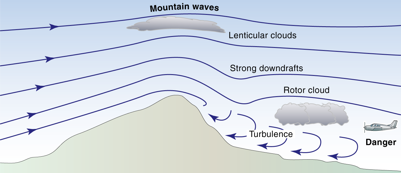
At low altitudes, turbulence is occasioned by vertical air movements or convective currents. Pilots have to remember that mountain flying requires the accumulation of a great amount of pre-flight information that includes, but is not limited to, wind direction, cloud reports, and wind speed (Wikson, 2014). During inflight observations, they have to be cognizant of standing lenticular clouds that are indicative of mountain waves to the lee of a mountain. When approaching mountains, pilots have to look for convective clouds suggesting turbulence. Figure 4 shows Turbulence in mountainous terrain.
Conclusion
The paper has explored aviation-significant atmospheric phenomena of clouds and wind. It has been shown that pilots should have extensive knowledge of these phenomena as well as their causes to increase the safety of their flights. To reduce the negative influence of the state of the atmosphere on their aircraft, pilots have to be cognizant of fog, mist, humidity, dew point types and levels of clouds, precipitation, thunderstorms, Coriolis force, gust, turbulence, and wind shear among others.
References
A thunderstorm [Image]. (2017). Web.
Convection current [Image]. (2017). Web.
Encyclopaedia Britannica. (n.d.a). Coriolis force. Web.
Encyclopaedia Britannica. (n.d.b). Gust. Web.
Experimental Aircraft Info. (n.d.). Precipitation. Web.
FAA. (2008). Wind shear. Web.
FAA. (2013). Thunderstorms. Web.
FAA. (n.d.). Clouds. Web.
Frey, R. (2015). Whether the weather: Aviation meteorology from A to Z. New York, NY: Books on Demand.
Turbulence in mountainous terrain [Image]. (2017). Web.
Types and levels of clouds [Image]. (2016).
UMBC. (n.d.). Condensation: Dew, fog, and clouds. Web.
Wikson, M. (2014). Meteorology for pilots. Marlborough, England: Crowood.
Williams, J. (2016). Weather: Correlating cloud types anticipate their effects on your flying. Web.