Introduction
In this paper, there is a plan to fly an unmanned aircraft system (UAS), which will be DJI Matrice multi-rotor aircraft on flight lines 25 meters apart from one another. There is a need to consider safety-critical aspects that ensure that the flight does not have constraints while in the air. Another major element to consider is minimizing the risk of collision with other aircraft by adhering to air traffic control measures (Alsadik & Remondino, 2020). In addition, it is notably important to consider elevation, airspace, airports, and possible hazards on the way. Other essential considerations comprise part 107 regulations, security access concerns, and crew resource management. This paper presents critical planning of the flight between Atlantic City and Washington DC on November 3, 2022.
Weather
Prevailing Wind Direction
The direction of a runway is influenced by wind direction. It is important to mention that wind pushes aircraft forward through the air, increasing its speed and shortening a journey. The direction of the wind should guide the flight, not fly on the opposite so that the aircraft reduces friction while on the way (Hashemi & Botez, 2022). Thus, such consideration is important in the planning of the flight.
Average Wind Speed
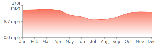
With reasonable proficiency and appropriate runaway measures, it is possible to handle winds up to 20 knots. However, for the UAS, the component may be around 10 knots will enable linear maneuvers from taking off to landing (Cox, 2021). The Wind in Washington DC and major parts of the US during the fall season is usually 13.1 mph based on historical data, as shown in Figure 1 below. Thus, wind speed should be a key factor to consider while planning the UAS flight on November 3.
Minimum and Maximum Temperature
For a plane to be in the air, the temperature is a key factor to check. It will be important to keep the temperatures between 22 to 24 degrees Celsius so that the system of the UAS does not have adverse effects from the heat in the aircraft (Echeveste et al., 2021). Flying must have key concerns about the high-altitude icing hazards that may tamper with the normal temperature range during the Fall season. The maximum temperature should be 27 degrees Celsius.
Weather Sources Used
In this paper, various weather sources were useful in getting the information presented for flight planning. The following were websites used; Federal Aviation Administration (FAA), NASA Aeronautics Research Mission Directorate, Google’s Earth Maps, and National Aeronautical Office. The websites have comprehensive information about wind direction, speed, and temperature. For instance, using Google Earth would navigate easily about the specific point on earth that one requires to find a given data.
Elevation
The maximum allowable altitude for UAS flights is 400 feet above sea level. The Medium altitude ling endurance for unmanned aerial vehicles is 300 feet above the ground, while the high-altitude long-endurance (HALE) is 420 feet above sea level (Echeveste et al., 2021). According to NATO, the lowest altitude long endurance (LALE) is 100 feet above the ground. Since the flight from Washington DC to New York is a short flight, the UAS aircraft will be required to move when 350 feet above sea level. However, the flight will be determined by the weather, turbulence, and safety factors (Fang et al., 2018). It is important to avoid flying in altitudes that probe the flight controller to look for an emergency landing to maintain the safety of the aircraft.
Airspace and Airports
Airspace can be categorized into controlled, uncontrolled, special use, and others. Controlled airspace regulations do not apply to UAS within the open category. For this division, an organization will be required to get permission to enter a controlled space when adhering to the terms of the authorization (Kuželka & Surový, 2018). FAA selected a few airports that can be used for UAS. In this case, the plan is to use Atlantic City International Airport and Seattle-Tacoma International Airport. The airports are preferred because of the capability they have in detecting, identifying, and monitoring unmanned aircraft. The US government has recently developed systems to counter the UAS system so that the aircraft can be tracked with modern aviation technologies.
Medical
The Southern Jersey Family Medical Center is the nearest medical center that will be useful in case of emergencies. The medical center can be reached at +1 856-853-8730, a phone number where one can talk to the medical receptionist for the facility. The appropriate address is 831 Kings Highway 100, West Deptford, NJ 08096, United States. This information is important as part of navigating the institution for medical services.
Hazards
The Atlantic City has various power lines that must be considered when planning for the flight. When flying, the UAS must be controlled in that it treats power lines like imaginary walls. This means there is a consideration jot to fly under the lines and keep a distance away from the horizontal and vertical perspectives (Cox, 2021). Due to the drone system used in UAS, it is possible to enable a power line detection system for determining precise locations for safe navigation.
It is important to consider towers and billboards for safety purposes, especially when taking off and landing. These infrastructures are erected high above the ground, which means there must be careful consideration not to tamper with the buildings and structures. By applying visual flight rules (VFRs), the controller of the UAS must ensure the weather is suitable as per the visual meteorological conditions (VMC) (Cox, 2021). If the weather is per the rules, it is easy to control the aircraft using instrument flight rules and aircraft traffic control. Since some parts of Atlantic city are congested, when the aircraft is moving at a lower altitude should be monitored not to get to the zone where towers and masts are high above the ground. That is part of preflight planning that is effective in minimizing hazards.
Bird-strike events are rare when flying, but there are strategies for preventing possible collisions. It is important to note the bird activities in particular areas as one way of avoiding these collisions. For the urban areas, the FAA plan is to adhere to Urban Air Mobility (UAM) as safe and effective aviation that uses automated systems to check urban areas where there might be busy events (Echeveste et al., 2021). The urban points need high altitude and low speed to prevent possible hazards. Terrain-following radar will be used to enable the UAS to flow at low altitudes such as 100 feet. For high elevation points, the plan includes a system integration that shall enable the aircraft system to automatically increase the flying altitude to enable the swift transition of the flight.
Air traffic management will require a data exchange that supports the flight framework, enabling visual lines and drone operations at low altitudes such as 400 feet above sea level. The UAS shall rely on data protocols configured by the integrated system using microservices aviation services for easily deploying and independent in regulating the commands (Hashemi & Botez, 2022). Environmental factors shall observe how the emission of gases shall be controlled. The plan is to apply new technologies in setting efficient flight paths to avoid delays. Additionally, lower-carbon alterative fuels ares a preferred plan for this case. Security and access concerns will be implemented by having a surveillance team while the aircraft is moving and also designing a receiving point that shall monitor the accessibility of the plane (Kuželka & Surový, 2018). General traffic will be manned by checking the flow of busy highways alongside the airports.
Part 107 Regulations
According to the FAA, there is a requirement that for UAS, the drones should be at least 55 pounds. The aircraft will be under 14 CFR Part 107, and in this, it is planned that the aircraft shall be 120 lb. The aircraft requires a beyond visual line of sight drone (BVLOS) technology since it requires fewer take-offs and landings; hence, cost-effective (Fang et al., 2018). For UAS aircraft, there is no need to maintain sustained flight over nonparticipants unless the person is operating a stationary object. There will be obtaining of airworthiness certificate under part 21 to operate over nonparticipants. The aircraft shall use high visibility strobe lights for flying at night, whereby the lights be visible at least three statute miles (Kuželka & Surový, 2018). The lights should frequently flash so that no collisions are possible.
The drones shall be on the IFR flight plan to avoid conflict with the approach with manned aircraft, which is allowed in the airport’s vicinity. The maximum speed allowed for the UAS is 100 mph or 87 knots. There is a need to have FAA certification under Section 349 of the rules. The same concepts apply to the altitude above 400 feet above the ground. The aircraft shall operate under Class E airspace as depicted in the previous sections. To have more than one aircraft at a time, the plan is to have approval from FP&M as the FAA expands in the future (Hashemi & Botez, 2022). Operation from a moving vehicle shall require a merging letter of approval from FAA on FTR rules on aircraft. For population density, the drone must satisfy R 2531 rule that allows operation in such perspectives. The same regulation is followed for hazardous material on board (Reichmann, 2021). For foreign-registered aircraft, it must meet FACE licensing from the transportation department.
Crew Resource Management
The pilot must have a certificate after passing the FAA part 107 test and exams that require one to be able to read and write and also understand English and be mentally and physically fit. The pilot must satisfy medical certifications on that part, which means they should not have infectious diseases or allergies that can disrupt normal operations (Echeveste et al., 2021). The pilot must be a visual observer who can predict the extent to which a line is affected and be able to call for reinforcement if required (Alsadik & Remondino, 2020). Additionally, the personnel should be trained in dealing with emergencies such as shortness of breath and other health complications.
Conclusion
Planning for the UAS-based flight requires prior planning on weather, hazard, crew management among other factors. When planning, there must be consideration of FAA regulations and also the Part 107 rules. The US has improved technology for guiding pilots who are controlling the unmanned aircrafts which has helped in navigating the airline systems. There is need to have a comprehensive plan that covers all the requirements as per FAA.
References
Alsadik, B., & Remondino, F. (2020). Flight planning for LiDAR-Based UAS mapping applications. ISPRS International Journal of Geo-Information, 9(6), 378. Web.
Cox, J. (2021). How hot is too hot for airliners to take off? How often do planes overfly hurricanes? Usatoday.com. Web.
Echeveste, D., Lee, A., & Clark, N. (2021). Using spatial uncertainty to dynamically determine UAS flight paths. Journal Of Intelligent & Robotic Systems, 101(4), 3-5. Web.
Fang, S., O’Young, S., & Rolland, L. (2018). Development of Small UAS beyond-visual-line-of-sight (BVLOS) flight operations: System requirements and procedures. Drones, 2(2), 13. Web.
Hashemi, S., & Botez, R. (2022). Lyapunov-based robust adaptive configuration of the UAS-S4 flight dynamics fuzzy controller. The Aeronautical Journal, 5(7), 1-23. Web.
Kuželka, K., & Surový, P. (2018). Mapping forest structure Using UAS inside flight capabilities. Sensors, 18(7), 2245. Web.
Reichmann, K. (2021). 5 Airports selected by FAA for countering unmanned aircraft systems – Aviation Today. Aviation Today. Web.