Introduction
Various geological processes have taken place at Yosemite National Park. These processes include volcanicity, weathering and erosion, faulting, and glaciation. Yosemite National Park is located along the western slopes of the Sierra Nevada Mountain range in central-east California. Yosemite National Park is a place where geological processes are well portrayed. It is recognized because of the natural features that are present in the region. These features include lakes, glaciers, waterfalls, meadows, granite cliffs, mountains, and giant sequoia groves. This paper explains the geological processes that took place and those that are active at Yosemite National Park.
Assembling California (The Paleozoic Era: 542–251 Million Years Ago)
Around 500 million years ago, current California was submerged towards the west of North America. The North American western margin was similar to the contemporary East Coast of North America (Glazner & Stock, 2010). Yosemite National Park was located west of the Cambrian shoreline. Materials such as shell fragments, silt, and mud drifted to the present Yosemite region, which solidified, forming siltstone, shale, and carbonate rock (Glazner & Stock, 2010).
Tectonic forces resulted in the formation of a deep trench that is located southwest of the park. Volcanic eruptions from the volcanic island were massive, and materials were deposited in this region (Glazner & Stock, 2010). Between 430 and 359 million years ago, the Shoo Fly region of the current Yosemite was compressed against the western side of North America by tectonic collisions (Glazner & Stock, 2010). The parts were stacked and folded, forming strata-like packages which are separated by the regional thrust. Around 385 and 345 million years ago, the coast of California continued to be subducted, and with continuous collision, the mountains in the Nevada region were formed.
Rise of the Batholith and Massive Volcanicity (The Mesozoic Era 251–65.5 million Years Ago)
Around 251 to 146 million years ago, the Calaveras complex was broken by the subduction of the oceanic plate moving eastwards beneath the Shoo Fly complex, merging it with the North American Continent. Around 145.5 to 65.5 million years ago, the tectonic regime resulted in the massive magma that led to the formation of the Sierra Nevada Batholith (Prothero, 2016). The collision of the two tectonic plates resulted in intense pressure and friction, which generated substantial heat that melted the rocks (Prothero, 2016). The buoyant magma formed emerged from the continental crust rich in silica, melting the overriding lithosphere partially (Glazner & Stock, 2010).
Around 140 and 80 million years ago, active volcanoes in the region erupted to the surface, leading to numerous distinct plutons, which combined to form the Sierra Nevada batholith (Lynch & Lynch, 2017). This activity is evident by the ten intrusive suites that are currently present at Yosemite National Park. The active volcanoes erupted, leading to the deposition of various volcanic materials, including ash that covered most regions of Yosemite Park. The current Sierra Nevada was formed as a result of tensional forces, which led to the thickening of the area from the thrust materials.
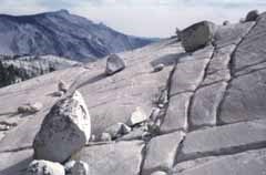
Plutonic igneous rock forms the central part of Yosemite National Park. Plutonic rock is formed when molten rock cools and solidifies deep underground at a prolonged rate, leading to the formation of large crystals (Glazner & Stock, 2010). The volcanic igneous rocks that formed close to the surface quickly solidifies forming small crystals. Figure 1.0 below shows the massive jointed granite currently present at Yosemite National Park.
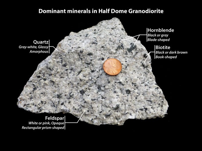
The plutonic rock present in Yosemite National Park includes quartz monzonite, granodiorite, quartz monzodiorite, and granite. The plutonic rocks at Yosemite are composed of minerals such as biotite, potassium fieldspar, hornblende, plagioclase fieldspar, and quartz (Lynch & Lynch, 2017). Figure 2.0 below shows the dominant minerals in Half Dome Granodiorite. The plutonic rocks differ in the proportion of fieldspar and quartz (Prothero, 2016). At Yosemite National Park, volcanic igneous rocks are scarce; however, the few present include latite tuff, latite lava flows, and basalt flow.
Granite is a plutonic igneous rock that dominates the park. Most of the visible terrain, including Mount Hoffman, is composed of granitic rocks (Browne et al., 2017). The Hetch Hetch valley and Yosemite cliff, among the national park’s highest peaks, have been shaped into bold forms. The rocks are massive and durable, forming striking shifted domes (Bartley et al., 2018). Despite granite rocks dominating most parts of the Yosemite National Park, they are not monolithic.
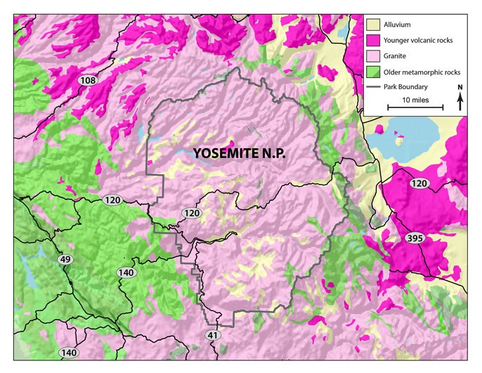
Granite rocks are a composite of numerous granitic rocks formed more than 100 million years ago because of magma intrusion (Anderson & Ferriz, 2016). This process explains the formation of the various types of granite rocks in Yosemite National Park. The differences in these rocks are not visually displayed but reflected on the varying ability to respond to weathering and erosion subjected to the rocks (Anderson & Ferriz, 2016). Figure 3.0 below shows the bedrock geology of the Yosemite National Park.
The region experienced massive volcanic eruptions which covered the ancient river canyons. The Little Devils was formed as a result of the lava flow that infiltrated the Grand Canyon (Tuolumne) (Klein & Jagoutz, 2021). The Tuolumne Grand Canyon is currently located on the southern side of the Sierra Nevada Mountains (Anderson & Ferriz, 2016). Little Devil Postpile is located a few miles west of the Tuolumne Meadows (Bartley et al., 2018). The Postpile is composed of fine-grained rock, dark-colored columnar basalt preserved by the cooling structures, which portrays the quick cooling and contraction of the dense lava.
The andesitic lava flowed towards the Grand Canyon’s northern side, leading to the development of the plugs from the faults on the margin of Dana Mountain. There was much evidence of rhyolite ash in the north part of the region (Bartley et al., 2018). However, most of the ash layers have been eroded due to erosion by the melted ice during the ice ages. The eastern side of the Yosemite National Park that borders long valley areas and Mono Lake has experienced continuous volcanic activity for the past 5 million years (Browne et al., 2017). The most noted volcanic activity was dated 700,000 years ago; it resulted in the formation of the Long Valley Caldera (Glazner & Stock, 2010). However, Yosemite National Park has no active volcanoes in the region.
Tension and Faulting (Paleogene and Neogene Periods: 65.5–2.6 million Years Ago)
Around 25 to 15 million years ago, the coast of California and a significant portion of the Farallon plate were utterly broken. The thick crust support was removed by the strike-slip movement leading to the collapse of the crust under the great basin and widening the range province and the basin (Klein & Jagoutz, 2021). The earth’s crust along the Sierra Nevada continued to get thin, resulting in the faults (Klein & Jagoutz, 2021). The hot mantle began to rise subsequently, which led to thermal expansion partial melting of the mantle. This activity resulted in the reduction of the rock density portrayed by the altitude on the eastern side of the Sierra Nevada (Klein & Jagoutz, 2021). Yosemite National Park is almost parallel to the boundary of the fault, which is between the Sierra Nevada and the Range and Basin.
Around 10 million years ago, the Yosemite region was uplifted by the vertical fault movement acting on the Sierra Nevada. The angle of tilting of the Sierra block amplified the uplift of the Sierra Nevada. This increased the gradient of the streams flowing towards the western side (Klein & Jagoutz, 2021). The fast flow streams cut the valleys quickly, and additional uplift occurred when the vast faults developed on the eastern side. This resulted in the creation of Range and Owens Valley (Klein & Jagoutz, 2021). The uplifting process and continuous erosion led to the formation of rounded shape domes at Yosemite National Park. This was a result of the exfoliation process that exposed granitic rocks to surface pressures.
Furthermore, mass wasting and uplift resulted in fracture joint planes, specifically vertical ones, resulting in the current solidified plutons. Acceleration of this process was enhanced by the Pleistocene glacier, which transported tallus from the flows of the valleys (Wesnousky & Owen, 2020). The vertical joints planes determined the erosion speed and the location of erosion. Most of the long and deep cracks in the region were created by the pressure resulting from uplift and removal of the overlying rocks by erosion.
Currently, the region continues to rise with an estimated uplift rate of 1.5 inches (4 centimeters) for every 100 years. The uplift is significantly experienced at Mount Dana, and it exceeds the uplift rate because of erosion leading to a substantial increase in elevation (Prothero, 2016). The rockfalls in the region continuously change the walls of the canyon, and the gradient of the river constantly engrave the valley floors (Prothero, 2016). Sediment deposition is continually filling the cirque glacier and alpine lakes.
Glaciation and Return of Volcanicity (Quaternary Period: 2.6 million Years – Present)
The Tahoe glaciation was the vast glaciation that covered Yosemite National Park from 140,000 to 80,000 years ago. The glaciation was extensive as it rose above the previous Tioga moraines on the park’s eastern side (Gómez-Ortiz et al., 2021). At the end of the Tahoe glaciation, volcanic activity returned (Gómez-Ortiz et al., 2021). Tioga glaciation resulted in the most recent glacial activity at the Sierra Nevada, which prolonged for around 26,000 to 18,000 years ago. Most of the current glacial activity at Yosemite National Park results from Tioga Glaciation remnants (Gómez-Ortiz et al., 2021). The temperature of the Sierra Nevada region dropped significantly. This is because the place had a high altitude leading to the formation of glaciers icefields over the area. Extensive coldness resulted in the covering of higher Regions of Yosemite with icefields and glaciers moving down the valleys (Gómez-Ortiz et al., 2021).
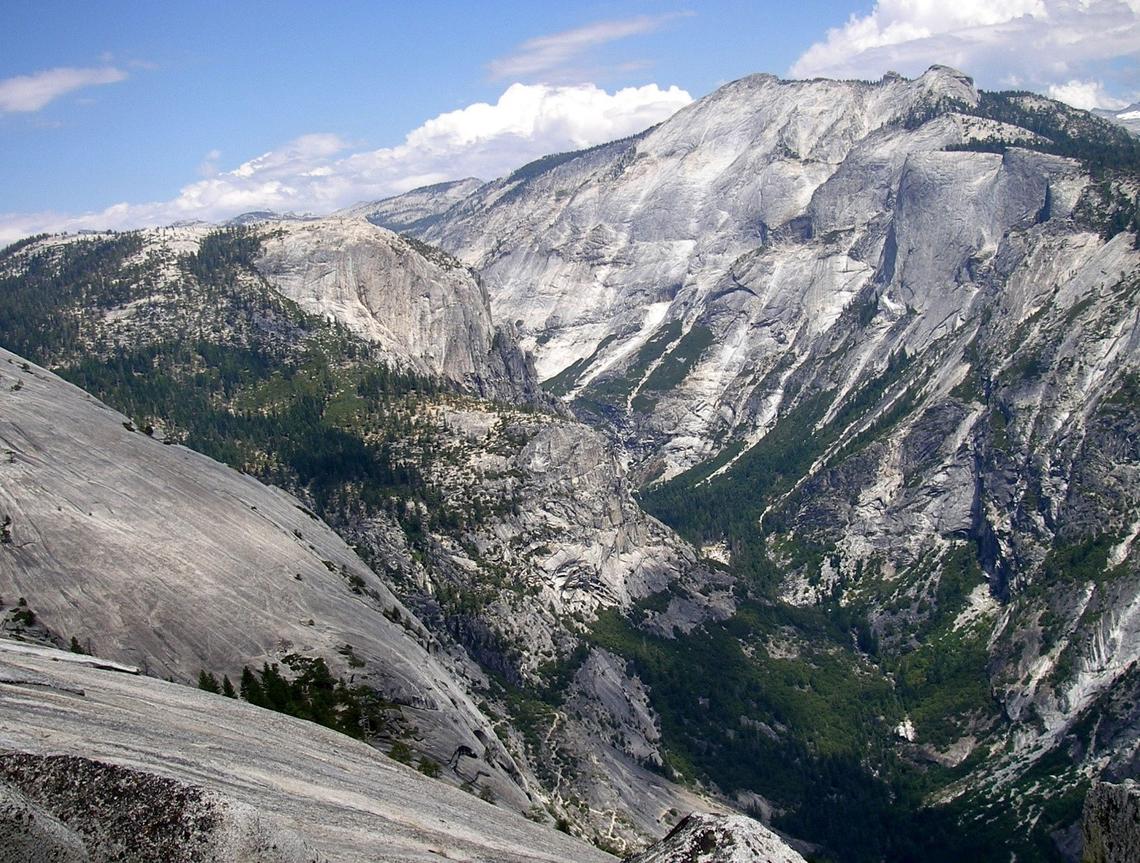
Figure 4.0 below shows the Yosemite Valley as seen from the northern Dome. The glacial ice eroded the place and transported large volumes of rubble which scoured and changed the landscape. The transported debris was widely distributed along the glacial margin, forming hummocky piles (Gómez-Ortiz et al., 2021). As the glacier melted, a large stream swelled with melted ice water moved most debris from Sierra to Central valley (Gómez-Ortiz et al., 2021).
Despite global warming increasing the melting rate, the glacial process adds materials to the terminal moraines as it polishes and scours the bedrock. The Park is currently exhibiting glaciation and plate tectonic processes (Gómez-Ortiz et al., 2021). With the erosion and weathering activities, it keep on reshaping the region. In 1871, a black mountain glacier was discovered, but it disappeared during the mid-1980s (Gómez-Ortiz et al., 2021). The remaining glaciers are Maclure and Lyell, which are expected to disappear in the near future because of the glacier’s climatic changes and natural ice melting.
Conclusion
In conclusion, the Yosemite National Park’s geologic history dates back to the assembling of California during the Paleozoic period. During this period, California was submerged west of North America. Due to tectonic forces, a deep trench located west of the park was formed, and massive volcanic eruptions began during this period. During the rise of the Batholith through the Mesozoic period, active volcanoes in the region led to the formation of the plutonic igneous rocks that forms the major part of the Yosemite National Park.
These rocks include quartz monzonite, granodiorite, quartz mononitrate, and granite. Faulting and glacial activity took place during the Cenozoic period, where uplifting led to the formation of rounded domes. During the Quaternary period, the Tahoe glaciation was the vast glaciation that covered most parts of Yosemite National Park. However, most of the current glacial activity in the region is from Tioga remnants. Currently, the park is exhibiting glaciation and plate tectonic processes, together with erosion and weathering activities, despite the park lacking active volcanic activity.
References
Anderson, R., & Ferriz, H. (2016). Applied geology in California (1st ed.). Star Pub Co.
Bartley, J., Glazner, A., & Coleman, D. (2018). Dike intrusion and deformation during growth of the Half Dome pluton, Yosemite National Park, California. Geosphere, 14(3), 1283-1297. Web.
Browne, B., Becerra, R., Campbell, C., Saleen, P., & Wille, F. (2017). Quaternary basaltic volcanism in the Golden Trout Volcanic Field, southern Sierra Nevada, California. Journal of Volcanology and Geothermal Research, 343, 25-44. Web.
Glazner, A., & Stock, G. (2010). Geology underfoot in Yosemite National Park. Mountain Press.
Gómez-Ortiz, A., Oliva, M., Palacios, D., & Salvador-Franch, F. (2021). The glaciers of the Sierra Nevada. Iberia, Land Of Glaciers, 505-524. Web.
Klein, B., & Jagoutz, O. (2021). Construction of a trans-crustal magma system: Building the Bear Valley Intrusive Suite, southern Sierra Nevada, California. Earth and Planetary Science Letters, 553, 116624. Web.
Lynch, D., & Lynch, B. (2017). Rocks & minerals of California. Adventure Publications.
Prothero, D. (2016). California’s amazing geology (1st ed.). CRC Press.
Wesnousky, S., & Owen, L. (2020). Development of the Truckee River terraces on the northeastern flank of the Sierra Nevada. Geomorphology, 370, 107399. Web.