Introduction
Virginia is divided into six provinces based on various physiographic features – topography and geology. Virginia’s provinces from East to West are Coastal Plain (Tidewater), Piedmont, Triassic Basins, Blue Ridge, Valley and Ridge (Appalachian Mountains), and Appalachian Plateau (Allegheny). The six provinces are not unique to the state of Virginia, and they happen to extend from New York to Georgia, oriented in a NE-SW. These regions exhibit formations of similar rocks assembled by geologic and tectonic activities spanning over a billion years (Bentley). Each province is characterized by unique geologic formation and history comprising rocks from different ages, different tectonic structures, and different fossils or lack of it.
Geologic Provinces of Virginia
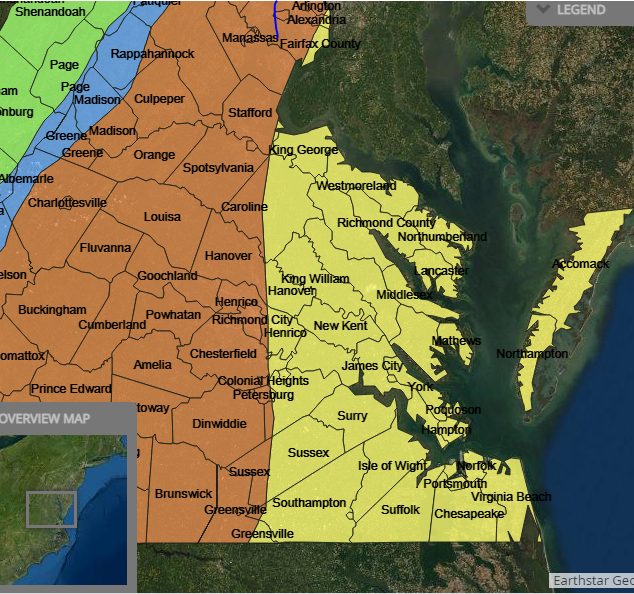
Coastal Plains
Coastal Plains province (Fig. 1) is flat with young, unconsolidated debris formed by older crystalline rocks. These debris layers were formed by erosion from the Appalachian Mountains and Piedmont, which were then deposited into the coastal plains during high sea levels in the past (Bentley). The sediments on the current continental edges are a continuity of the coastal plain sedimentation, piling up since the Triassic (“The Geology of Virginia.”). The coastal plain sediment deposits are shaped like a wedge if looked in a cross-section, thick eastwards and slimming to a feather edge westwards.
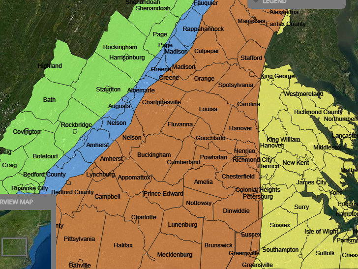
Piedmont
Piedmont (Fig. 2) is a place of rolling hills formed by old igneous and metamorphic rocks. There are two different categories of rocks found in Piedmont; one of them is the metamorphic and igneous rocks. The second one is the lower Mesozoic sedimentary rocks that were deposited in the basins and made into igneous and metamorphic rocks (“The Geology of Virginia.”). Also cutting along the Triassic-Jurassic sediments are several igneous dikes; small pieces of igneous rocks and lava flow from the volcanic activity. The igneous rocks are the source of volcanoes formed during an old occurrence of subduction that happened before the creation of the Appalachian Mountains.
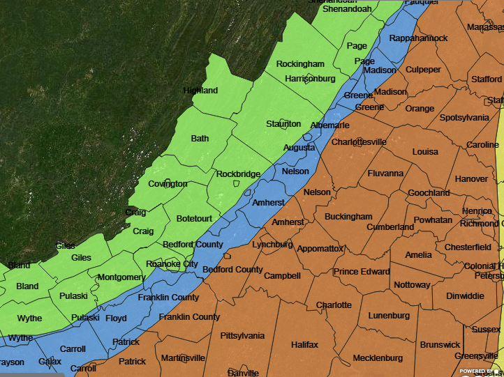
Blue Ridge
The Blue Ridge (Fig. 3) separates Piedmont from the Valley and Ridge province. In terms of structure, the Blue Ridge province can be described as a large, eroded anticline that is overturned from the west. The core of this anticline is made of igneous and metamorphic rocks together known as the Greenville, although there are late ancient Proterozoic intrusives and debris present. They are the oldest in Virginia, about 1.1 billion years (“Virginia Provinces”). The east and west of the anticline comprise much younger volcanic and clastic deposits. The igneous rocks comprise piles from the volcano and the granite batholiths entering Greenville.
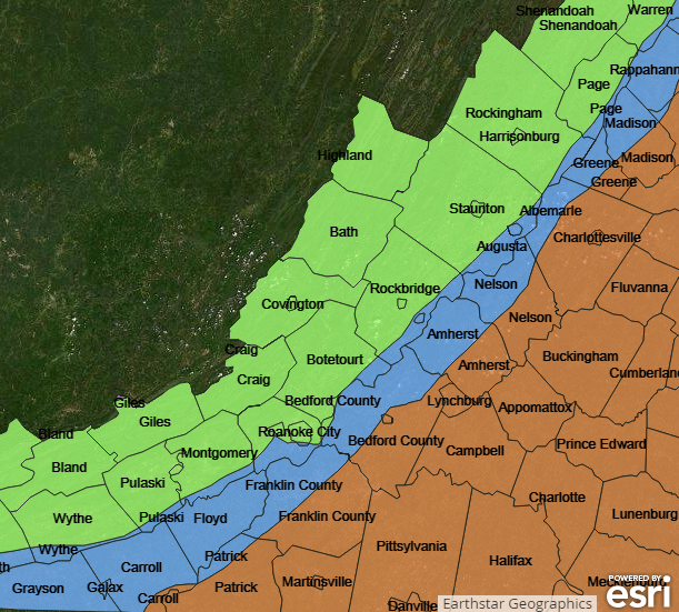
Valley and Ridge
This is an area with long parallel ridges and valleys from the old faulted and folded sedimentary rocks. This occurred after a collision during the ancient Paleozoic era between Africa and North America. The Valley and Ridge, as shown in Fig. 4, lies near the Allegheny plateau and the Blue Ridge; its boundary lying at the west is called the Allegheny front (“Virginia Provinces”). The rocks in Valley and Ridge are sedimentary, thrust folded to form the anticlines and synclines during the middle and the lower Paleozoic ages, and have a trellis pattern. The ridges came about because of the hard rocks that do not erode easily compared to the softer rocks found in the valley.
Appalachian Plateau
The Primary rocks in the Appalachian Plateau are sedimentary rocks. The province has an irregular, rugged topography brought about by ancient, flat-lying sedimentary rocks. Although the plateau has some high elevation levels in some parts, the lower parts are majorly dissected by streams with dendritic-like drainage patterns and seemingly rugged topography (“Virginia Provinces”). The Appalachian Plateau is located northwest of the Valley and Ridge and basically has a series of Paleozoic sedimentary rocks.
Triassic Basins
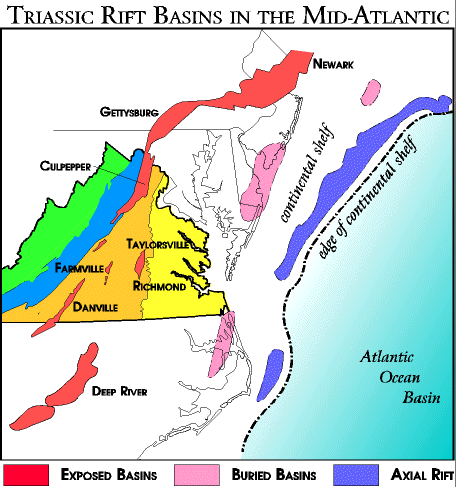
The lower Mesozoic debris accumulating in the fault basin is commonly known as the Triassic basin deposits, they are known to contain Jurassic rocks. These basins were developed when North America separated from Africa to form the Atlantic Ocean(“Virginia Provinces”). The Culpeper basin in Piedmont along the Blue Ridge province is the biggest, but several small basins such as Farmville, Danville, and Richmond are scattered around Piedmont.
Basins were formed by the cracks when the land moved from Connecticut to Alabama during the Triassic and Jurassic periods. Volcanic magma rose and formed sills, dikes, and lava that flowed over the surface, leading to the formation of the basins (“Virginia Provinces”). When the magma cooled, it also formed igneous rocks known as basalt and diabase. The fossils of extinct species like dinosaurs began revitalizing life during the Triassic period. The Triassic debris held the organic materials which later decayed and became the natural gas and carbon dioxide.
Geologic History of Virginia
Greenville Orogeny
The Greenville Orogeny was a prolonged event that led to the building of the Mesoproterozoic mountain; it involved the construction of the Rodina supercontinent. It is evidenced by an orogenic belt that spans a considerable part of North America (“Grenville Event”). The earth’s oldest object is a 4.6-billion-year-old meteorite formed from a rock formed from an andesite crystallized rock (“Grenville Event”). The Nellysford gneiss is the oldest rock found in Virginia in Nelson County and is 1.8 billion years. Most of Virginia was yet to be created when it cooled into its present form.
In geology, igneous and metamorphic rocks are usually the base of a continent onto which sedimentary rocks are stacked. Even though these base rocks are present across the entire continent, they are only exposed when erosion has exposed old mountain ranges. In Virginia, these basement rocks are called “Greenville” and are the oldest rocks recorded. They can be found in eastern North America from North Carlina to Newfoundland. These rocks are the oldest and have a rich history marked by the Greenville Orogeny, the event that occurred 1.1 billion years ago (“Grenville Event”).
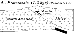
The Orogeny even occurred after a collision and overriding event between “Africa” and the edge of North America, building a mountain range as big as the Himalayas. Greenville rocks are most apparent in the Blue Ridge Province that including the Blue Ridge mountains (“Grenville Event”). This is along the Skyline Drive strip and the land to the east of the mountain from north of Galax through Charlottesville, Warrenton, Culpepper, and beyond (“Grenville Event”). Today, the rocks are found in the overturned anticline, which contains Greenville rocks in its core.
Rodinia Supercontinent
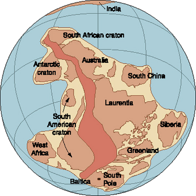
Approximately a billion years ago, the continental crust pieces joined together to form one giant supercontinent called Rodina, as shown in Fig. 6. A large ocean surrounded the continent and covered most of the globe. The single-lid theory says that Rodina might have been a solid, unfragmented lithosphere as opposed to a single plate mosaic. The Rodinia supercontinent lasted 600 million years, from around 1.6 billion years ago to about 1 billion years ago. Virginia is at the center of that supercontinent between the seashores and the rainstorms. The Virginia of that time had a continental climate that can be compared to that of the Gobi Desert in China or the Tibetan Plateau.
The Greenville mountains and all of Rodinia were barren, lacking plants or trees. Algae in the ocean were photosynthesizing and releasing oxygen as a by-product into the atmosphere that killed most of the earlier lifeforms. Evolution had yet to produce land plants yet, so all of Virginia at that time was rocks and rivers/lakes. Even though the collision of the continental plates was pushing the Greenville Mountains, the exposed rock was getting eroded by rain. Rivers created valleys, and the sediments flowed downstream to create shorelines. The eroding of the uplifts washed away close to 15 miles of rock. In the current day, erosion has been exposed once buried.
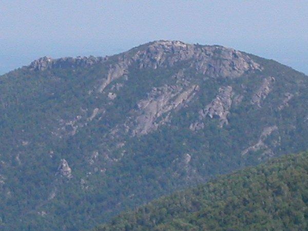
Igneous rocks formed more than a billion years ago are now exposed at Shenandoah National Park. The Greenville event(s) involved continental collisions that generated a lot of energy in the form of heat and pressure; the heat melted rocks to form granite and gneiss. The crystalline rocks are currently part of the Blue Ridge mountains which includes Madison County’s Old Rag Mountain, shown in Fig. 7. Greenville rocks as old as 1 billion years can also be seen exposed today at State Farm granite (Fig. 8) northwest of Richmond.
Break-Up of Rodinia And Formation of The Iapetus (Proto-Atlantic) Ocean
Typically, mountains do not last long in geology; after the Greenville Orogeny event, eastern North America experienced a period of quiet that lasted several hundred million years when Africa fused with North America to form Rodinia. During the Rodinia phase, the Greenville mountains eroded to the sea, and by about 600 million years ago, the area had been flattened (Fichter and Baedke). However, during the Proterozoic and early Cambrian, Africa and North America began to drift apart to form the new Proto-Atlantic, Iapetus, ocean. The rifting event ran for thousands of miles along the east of North America (Fichter and Baedke).
The axis of the rift runs down the Blue Ridge Province in Virginia. In structural terms, rifting occurs when the continental crust gets heated by magma from below the earth’s interior and swells up, stretches out, and thins out, forming cracks and developing faults. Some earth blocks slide into the valley in the faults to form what are called graben, while the same for mountains are called horsts.
The center of the system contains an Axial Rift, a steep-sided, narrow valley about 50-100 kilometers wide but dropping at least a kilometer below sea level. It may be dry at first but is filled up by the sea. On the opposite of the Axial Rift, horsts are one or two kilometers above sea level. The horsts on either side of the axial rift are called continental terraces. The remnants of the axial rift can be found in Charlottesville and Culpepper regions. The Lynchburg Group sedimentary rock indicates that the valley received coarse gravels from the horst mountains on either side during the rifting. One side of the graben is North America while the other side is Africa.
Taconic Orogeny
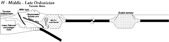
The Taconic Orogeny occurred when a series of terrains collided with eastern North America along the east-dipping subduction region. Since the subduction dipped eastward, it acted as a ramp with the terrane being forced to slide up onto the continental edge forming the Taconic mountains (Fichter and Baedke). The west is pressed into the foreland basin as the mountain rises up the craton; the hinterland is the overriding terrain that creates the mountain, as shown in Fig. 9 (Fichter and Baedke). Erosion of the mountain settles into the basin, and by the time the mountain is eroded, the basin is full. The orogeny is completed, and the terrain is wholly joined to North America.
The Taconic Orogeny is a rather complex story; the Cambo-Ordovician continent’s eastern edge was rifted in a zig-zag fashion. Regions like Southwest Virginia and the southeastern Pennsylvania promontory protruded out and got hit the hardest. There are protected re-entrants in the middle where there is a soft collision; as a result, the entire coastline was not hit uniformly (Fichter and Baedke). Moreover, the Taconic terrane does not approach North America perpendicularly but from the southeast at an angle that ensured it would not hit it uniformly. Furthermore, the Taconic terrane would collide with southwest Virginia first then with southeast Pennsylvania (Fichter and Baedke). For this reason, orogeny has different forms in different places. There is also a possibility that the various belts making up the Taconic terranes from the Piedmont belt collided at different times.
Acadian Orogeny
The Acadian Orogeny was first noted in the 19th century in the extremely metamorphosized rocks of Bay Fundy, Canada. The orogeny formed a continuous mountain chain along the east coast from southern Virginia north to Newfoundland; from here, it connected with the Caledonides continuing for thousands of kilometers between Scandinavia and Greenland (Fichter and Baedke). The Acadian and the Caledonian orogenies created the Laurussia supercontinent, also referred to as the Old Red Sandstone continent (Fichter and Baedke). The Acadian Orogeny happened at the early stages of another mountain-building epoch in the earth’s history that lasted about 150 million years.
Just as the Taconic Orogeny, the Acadian Orogeny led to the widening of the North American continent. The terrains that arrived on the shores of Virginia would extend the North American continent east of the Greenville-era Blue Ridge while also increasing the depths of more recent sediments that had eroded to the east and the west (Fichter and Baedke). During this Orogeny, the modern Blue Ridge was buried below the surface, with the rocks of the modern-age Blue Ridge being about 40 miles east of the current location. The crests of the Acadian-time mountains were situated around today’s Interstate 95 route, while the submerged Blue Ridge was to the west below the Acadian-time mountains.
Alleghenian Orogeny
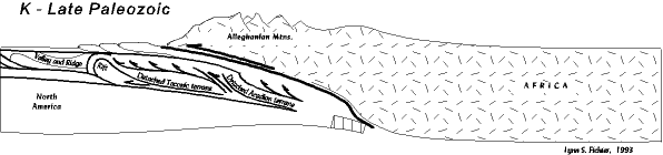
The Alleghenian is the last major orogenic era to affect the Mid-Atlantic. The Appalachian Mountains resulted from an uplift without the involvement of a plate boundary and are therefore not real mountains (Fichter and Baedke). The orogeny was occasioned by northwest Africa, part of Gondwana, coming into collision with the eastern seaboard of North America, covering the proto-Atlantic Ocean, as shown in Fig. 10. The Taconian and Acadian orogenies had already impacted Virginia, but the Alleghenian was significantly different in that this orogeny made the entire state become a mountain range, likely Himalaya in size. The process deformed all of Virginia’s rocks by folding, faulting, and thrusting them out of shape; these are reflected every day in the landforms, structures on roadcuts, and physiographic provinces.
Pangaea Supercontinent Formation
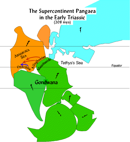
The third division of the earth’s history is also called the Mesozoic. This era is also called the “Age of Reptiles” since it is then that dinosaurs ruled the planet. It is during this period that the last earth’s major supercontinent, Pangaea formed (Fig. 11). Pangaea means “all earth” and began to combine over 300M years ago, lasting 150 million (Swaby et al. 14). All the earth’s continents had assembled to form a giant supercontinent.
The Rifting of Pangaea
Throughout Virginia and Mid-Atlantic geologic history, there are periods when there exists little geologic information to show the specifics of what happened. One such period was after the Greenville event 1.1 billion years ago up until the start of the Crossnore igneous event about 800 million years ago (Fichter and Baedke). From the sediments in southwest Virginia’s Harlan Formation, through the Permian period to the Late Triassic, records do not exist in Virginia or the Mid-Atlantic regions that tell what happened. Geologists are only left with the option of speculating from before and after events and extrapolating from similar geologic events.
What is known is that Virginia lay deep in the interior of the Pangaea supercontinent and that it was joined to northwest Africa (Fichter and Baedke). One can deduce that during the Permian period, the last segments of the Alleghenian mountains were breaking since several sediment layers eroded can be found in southwest Pennsylvania and West Virginia(Fig. 12).
Chesapeake Bay Meteorite Impact
A bolide, approximately 1-3 miles in diameter, hit the ocean bed off the edge of the North American continent (Fig. 13). The object reached the continental shelf after going through 600-1500 ft of water. It drilled through 1800-3000 ft of sediments, and after hitting the granite crust, it continued traveling until its kinetic energy was exhausted (“The Rest of the Story”). The bolide vaporized/displaced water and sediments and excavated a hemispherical crater into the crystalline basement. Moreover, it affected nearby sediments on the continental creating fractures as deep as 7 miles (“The Rest of the Story”). The bolide would superheat and vaporize into gas with melted bedrock ejecting into a plume 15-30 miles high.
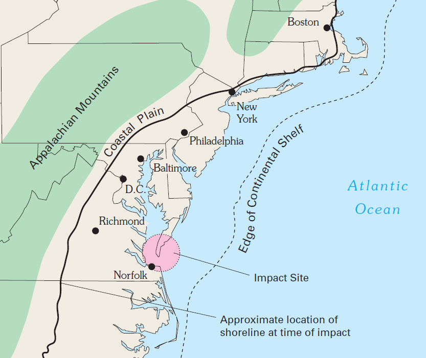
Some debris that had been completely altered by the impact would be flung to the Continental Shelf close to New Jersey. Geologists who were exploring for oil discovered small glass beads called tektites and shocked quartz in the 1980s, offering a clue as to the existence of an impact crater in close proximity(“The Rest of the Story”). The specific location of the Chesapeake crater was not discovered and written scientifically until the 90s.
Conclusion
Virginia is one of the most exciting places geologically in the US and in the entire world. It is divided into six geologic provinces: the Appalachian Plateau, Blue Ridge, Coastal Plain, Piedmont, and Valley and Ridge. These provinces are not confined to the state borders of Virginia but, indeed, do extend to other states. Virginia has a significant geologic history with plenty of records from various ages, from the Greenville Orogeny to the Chesapeake meteor event. There are few places in the world where a geologist would feel at home more than in the state of Virginia.
Works Cited
Bentley, Callan. “Geology of Virginia 2014” YouTube, uploaded by Bentley Callan, 2014. Web.
Fichter , Lynn S., and Steve J. Baedke. “The Supercontinent Pangaea in the Late Paleozoic.”CSM. Web.
Fichter, Lynn S., and Steve J. Baedke. The Devonian Acadian Orogeny And Catskill Clastic Wedge. Web.
Fichter, Lynn S., and Steve J. Baedke. “Rifting of Pangaea: Initiation of the Atlantic Ocean.”CSM. Web.
Fichter, Lynn S. , and Steve J. Baedke. “The Grenville: A Major Mountain Building Event.”CSM. Web.
Fichter, Lynn S., and Steve J. Baedke. “The Late Paleozoic Alleghanian Orogeny.” CSM. Web.
“Grenville Event and Virginia Geology.”VirginiaPlaces. Web.
“Rocks and Ridges – the Geology of Virginia.”. Web.
Swaby, Andrielle N., et al.,. The Teacher-Friendly Guide to the Earth Science of the Southeastern US. 2nd ed, Paleontological Research Institution, 2016.
“The Geology of Virginia.” The Geology of Virginia. Web.
“The Rest of the Story About Virginia Geology.” VirginiaPlaces. Web.
“Virginia Provinces.” ESRI. Web.